
Barrabool Land System
Download the pdf version of this document: Barrabool Land System (PDF - 544 KB)
To view the information, PDF requires the use of a PDF reader. This can be installed for free from the Adobe website (external link).
| Rolling hills with fertile soils to the west of Geelong lie mainly to the north of the present study area, but a small section forms the northern part of the catchment of Thompson Creek. These hills are on Lower Cretaceous sandstones and mudstones similar to those outcropping extensively in the Otway Range, but the landscape is more subdued and the rainfall is significantly lower. The original structure and species composition of the native vegetation are difficult to determine. The are has been extensively cleared for cropping and grazing and subdivided into somewhat smaller paddocks than the less fertile areas to the south. From the presence of isolated trees, Eucalyptus globulus and E. cypellocarpa formed part of the original vegetative community, and it is probable that E. radiata was also common. | 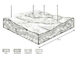 |
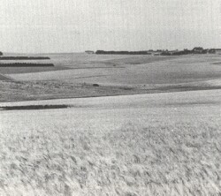 These rolling hills have been extensively cleared, and only single trees remain as indicators of the former native vegetation. | 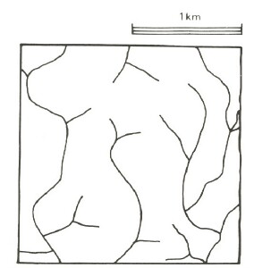 |
Area: 115 km2 | Component and its proportion of land system | |||
1 10% | 2 60% | 3 25% | 4 5% | |
| CLIMATE Rainfall, mm | Annual: 650, lowest January (30), highest September (60) | |||
| Temperature, 0oC | Annual: 14, lowest July (9), highest February (19) | |||
Temperature: less than 10oC (av.) June - August | ||||
Precipitation: less than potential evapotranspiration and October – early April | ||||
| GEOLOGY Age, lithology | Tertiary and Quaternary clay, silt and sand cappings | Lower Cretaceous feldspathic sandstone and mudstone | ||
| TOPOGRAPHY Landscape | Rolling Hills | |||
| Elevation, m | 100 -170 | |||
| Local relief, m | 25 | |||
| Drainage pattern | Dendritic | |||
| Drainage density, km/km2 | 3.1 | |||
| Land form | Hill | Valley Floor | ||
| Land form element | Crest, upper slope | Crest, slope | Lower slope | - |
| Slope (and range), % | 4 (1-5) | 11 (1-15) | 8 (2-10) | 2 (10-4) |
| Slope shape | Convex | Convex | Linear | Concave |
| NATIVE VEGETATION Structure | Woodland | Open forest | Open forest | Open forest |
| Dominant species | E. ovata, E. viminalis | E. globulus, E. cypellocarpa | E. globulus, E. cypellocarpa | E. viminalis, E. cypellocarpa |
| SOIL Parent material | Clay, silt and sand | In-situ weathered sandstone and mudstone | Colluvial weathered sandstone, mudstone | Alluvial silt, clay, sand, sandstone, mudstone |
| Description | (Variable soils) | Brown duplex soils | Brown duplex soils | Grey gradational soils |
| Surface texture | Sandy loam | Loam | Fine sandy clay loam | Clay loam |
| Permeability | High to moderate | Moderate | Moderate | Low |
| Depth, m | >2 | 1.0 | 1.4 | >2 |
| LAND USE | Dairy farming; cropping; beef and cattle grazing. | |||
| SOIL DETERIORATION HAZARD Critical land features, processes, forms | Low inherent fertility and high permeability lead to nutrient decline. | Steeper slopes are prone to sheet erosion. | Steeper slopes are prone to sheet erosion. | Run-off from adjacent hills may result in gully erosion. High seasonal water table leads to waterlogging and soil compaction. |
© State of Victoria (Agriculture Victoria) 1996 - .

This work, Victorian Resources Online, is licensed under a Creative Commons Attribution 4.0 licence. You are free to re-use the work under that licence, on the condition that you credit the State of Victoria (Agriculture Victoria) as author, indicate if changes were made and comply with the other licence terms.
The licence does not apply to ‘branding’ or some ‘images or photographs’ that may be owned by third parties. We ask you to seek prior approval to use images using the VRO feedback form. Access to higher quality images can also be provided on request.
This page was last updated on .