
14.3 Point Ronald, Princetown
|
This information has been developed from the publications:
|
| Location: | 14-873138. The area extending 1.75 km north-west and 1.5 km east of the Gellibrand River mouth. | 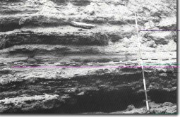 Phosphate nodules band (between pecked lines) in the type section of the Clifton Formation at Point Ronald, Princetown. |
Access: | Walking track off Great Ocean Road one kilometre west of Princetown recreation reserve. | |
Ownership: | Mainly Crown Land (Port Campbell National Park) and private land. | |
Geology: | The cliff includes the type section for the Clifton Formation, a marine unit of Late Oligocene age. The exposure is limited to a 50 metre long sector of the cliffs with a total thickness of 12 metres. It includes a distinctive bed up to one metre thick with phosphatic nodules. To the west, this formation is overlain by Gellibrand Marl. The major part of the cliffs here and at Point Ronald consists of aeolian calcarenite. At the mouth of the Gellibrand River, the cliffs expose at least six calcareous dune limestone sequences separated by weathering horizons and soils. Overlying the dune limestone are stabilised parabolic cliff top dunes. | |
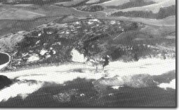
Geomorphology: | The Gellibrand River is frequently closed by a sand barrier and from this barrier an extensive transgressive dune has moved into the river valley. This dune is only partly stabilised and there are several saucer-shaped active blow-outs. The valleys of the Gellibrand River and La Trobe Creek contain alluvial deposits and shell beds and where they have not been artificially drained are swampy and the streams are reed-fringed. The small almost isolated hill (the site of Princetown township) which stands in the flood plain of the La Trobe Creek and Gellibrand River represents a stage in the formation of the cut-off spurs included in Site 14.7. The hill is an outcrop of the Gellibrand Marl capped by fluviatile quartz sands and gravels deposited during Pleistocene at a time when discharge of the Gellibrand was much greater. These and similar gravels on the south bank of the Gellibrand (Site 14.7) now stand as remnant high level terraces. | |
Significance: | State. The area includes a type section which has very limited outcrop elsewhere. The sequence of aeolian beds is one of the most extensive and accessible in Western Victoria and the cliff top dunes are well preserved. The site shows a variety of Tertiary and Quaternary sediments representing a wide range of terrestrial, estuarine and marine depositional environments and may be usefully compared with similar features at the mouth of the Aire River. | |
References: | Baker, G. (1944). "The geology of the Port Campbell district." R. Soc. Vict. 56: 76-108. Wopfner, H. & Douglas, J.G. "The Otway Basin of southeastern Australia." Spec. Bull. geol. Surv. S. Aust.:464 pp. Douglas, J.G. & Ferguson, J. (1976). "Geology of Victoria." Geol. Soc. Aust. Spec. Pub. 5: 528 pp. | |
 Transgressive dune at the mouth of the Gellibrand River. | 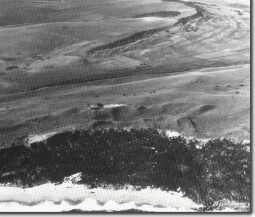 Escarpment (background) in Port Campbell Limestone. Bridgewater Formation dune limestone in foreground capped with Pleistocene dunes. Between the two is the alluvial valley of the La Trobe Creek. |
© State of Victoria (Agriculture Victoria) 1996 - .

This work, Victorian Resources Online, is licensed under a Creative Commons Attribution 4.0 licence. You are free to re-use the work under that licence, on the condition that you credit the State of Victoria (Agriculture Victoria) as author, indicate if changes were made and comply with the other licence terms.
The licence does not apply to ‘branding’ or some ‘images or photographs’ that may be owned by third parties. We ask you to seek prior approval to use images using the VRO feedback form. Access to higher quality images can also be provided on request.
This page was last updated on .