
4.3 Valley Swamp - Kawarren East
This information has been developed from the publications:
|
| Location: | 4-286360. Three kilometres south east of Kawarren. | 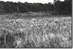 Valley swamp south of Kawarren |
Access: | Kawarren East Road. | |
Ownership: | Crown land. | |
Geomorphology: | The wide flat valley floor of a tributary of Porcupine Creek is swampy and supports a dense wet heath vegetation. Peat has accumulated to a thickness of at least two metres indicating a long history of blocked or impeded drainage at some point lower in the valley. | |
Significance: | Regional. The cause of the extensive swamp development is not clear. The peat would provide a basis for studies of vegetation development and drainage evolution. | |
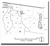 Site 4.3 |
© State of Victoria (Agriculture Victoria) 1996 - .

This work, Victorian Resources Online, is licensed under a Creative Commons Attribution 4.0 licence. You are free to re-use the work under that licence, on the condition that you credit the State of Victoria (Agriculture Victoria) as author, indicate if changes were made and comply with the other licence terms.
The licence does not apply to ‘branding’ or some ‘images or photographs’ that may be owned by third parties. We ask you to seek prior approval to use images using the VRO feedback form. Access to higher quality images can also be provided on request.
This page was last updated on .