
WCSS06
Location: Bellarine
Australian Soil Classification: Hypercalcic, Mottled-Subnatric, Brown SODOSOL
General Landscape Description: Rises.
Site Description: Upper slope (8% slope) of a hill slope.
Geology: Tertiary (Neogene) sediments, poorly consolidated ferruginised sandstone.
Land Use: Vineyard.
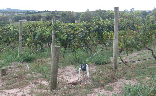
WCSS06 Landscape
Soil Profile Morphology:
Surface Soil
| A11 | 0-15 cm | Dark brown (7.5YR3/2); light sandy loam; weak structure; rough faced peds; weak consistence dry; pH 6.3; clear change to: | 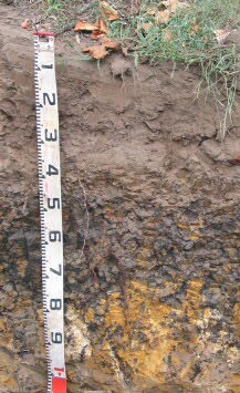 WCSS06 Profile WCSS06 Profile |
| A12 | 15-25 cm | Dark brown (7.5YR3/2); heavy loamy sand; massive; earthy fabric; weak consistence dry; contains a few coarse (6-22 mm in size) ferruginous and ferro-manganiferous concretions; pH 5.4; clear change to: | |
| A2 | 25-40 cm | Brown (7.5YR4/2); heavy loamy sand; massive structure; earthy fabric; weak consistence dry; very coarse ferruginous nodules common; many distinct clay cutans present; pH 5.9; clear and wavy change to: | |
| Subsoil | |||
| B21 | 40 - 70 cm | Yellowish brown (10YR5/4) with many very dark grey (10YR3/1) and yellowish red (5YR5/8) mottles; medium heavy clay; strong very coarse angular blocky, parting to strong medium angular blocky structure; smooth faced peds; very firm consistence moderately moist; contains a few very coarse soft calcareous segregations in patches as well as very few coarse fragments; many distinct clay cutans evident; pH 6.4; changing to: | |
| C1 | 70 – 90 cm | Yellowish brown (10YR5/6) with many very dark greyish brown (10YR3/2) and very pale brown (10YR7/3) mottles; sandy clay; moderate fine polyhedral structure; rough faced peds; contains many very coarse calcareous soft segregations, as well as many angular ferruginised sandstone fragments; some distinct infill evident; highly calcareous; pH 8.7; changing to: | |
| C2 | 90 – 130+ cm | Yellowish brown (10YR5/6) with many very dark greyish brown (10YR3/2) and very pale brown (10YR7/3) mottles; sandy clay; massive; contains a common amount of very coarse soft calcareous segregations; contains abundant ferruginised sandstone fragments; some distinct clayey infills evident; highly calcareous; pH 8.8. |
Soil Profile Characteristics:
pH | Salinity Rating | |||
Surface (A1 horizon) | Slightly Acid | Low | Non-Sodic | None 1 |
Subsoil (B21 horizon) | Slightly Acid | Low | Sodic | Moderate1 |
Deeper Subsoil (at 90-130+ cm) | Strongly Alkaline | Low | Sodic | Strong |
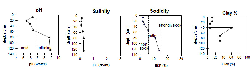
| The surface and upper subsoil is slightly acidic. The deeper subsoil is strongly alkaline. | The salinity rating is low throughout the profile. | The surface is non-sodic. The subsoil is sodic, with sodicity increasing with depth. | There is a sharp increase in clay content at the surface / subsoil boundary. |
Horizon | Horizon Depth (cm) | pH (water) | pH (CaCl2) | EC dS/m | Sodium Chloride % | Exchangeable Cations | |||
Ca | Mg | K | Na | ||||||
meq/100g | |||||||||
A11 | 0-15 | 6.3 | 5.7 | 0.14 | 5.6 | 1.4 | 0.82 | 0.33 | |
A12 | 15-25 | 5.4 | 4.8 | 0.1 | 2.6 | 0.66 | 0.24 | 0.2 | |
A2 | 25-40 | 5.9 | 5.2 | 0.09 | 2.6 | 0.61 | 0.23 | 0.25 | |
B2 | 40-70 | 6.4 | 5.6 | 0.2 | 11 | 9.0 | 0.48 | 1.8 | |
C1 | 70-90 | 8.7 | 8.1 | 0.27 | 0.01 | 6.1 | 4.7 | 0.34 | 1.4 |
C2 | 90-130 | 8.8 | 8.2 | 0.26 | 0.01 | 4.7 | 3.5 | 0.24 | 1.4 |
Horizon | Horizon Depth (cm) | Oxidisable Organic Carbon % | Nitrogen g/100g | Exchangeable Aluminium mg/kg | Exchangeable Acidity meq/100g | Field Capacity pF2.5 | Wilting Point pF4.2 | Coarse Sand (0.2-2.0 mm) | Fine Sand (0.02-0.2 mm) | Silt (0.002-0.02 mm) | Clay (<0.002 mm) |
A11 | 0-15 | 2.2 | 0.13 | <10 | 5.1 | 16.4 | 5.3 | 7 | 71 | 6 | 11 |
A12 | 15-25 | 1.3 | 0.06 | <10 | 5.4 | 14.7 | 4.5 | 10 | 72 | 4 | 11 |
A2 | 25-40 | 0.83 | <0.05 | <10 | 4.8 | 14.5 | 4.6 | 25 | 62 | 9 | 6 |
B2 | 40-70 | 1.1 | 0.1 | <10 | 10 | 42.4 | 23.1 | 2 | 30 | 3 | 61 |
C1 | 70-90 | 23.8 | 13.0 | 6 | 52 | 2 | 31 | ||||
C2 | 90-130 |
Profile Described By: David Rees and Siegfried Engleitner (March 2010).
© State of Victoria (Agriculture Victoria) 1996 - .

This work, Victorian Resources Online, is licensed under a Creative Commons Attribution 4.0 licence. You are free to re-use the work under that licence, on the condition that you credit the State of Victoria (Agriculture Victoria) as author, indicate if changes were made and comply with the other licence terms.
The licence does not apply to ‘branding’ or some ‘images or photographs’ that may be owned by third parties. We ask you to seek prior approval to use images using the VRO feedback form. Access to higher quality images can also be provided on request.
This page was last updated on .