
SW94
Location: Batesford
Australian Soil Classification: Ferric, Mottled-Hypernatric, Grey SODOSOL
General Landscape Description: Escarpment south side of Moorabool River.
Site Description: Upper slope
Geology: Moorabool Viaduct
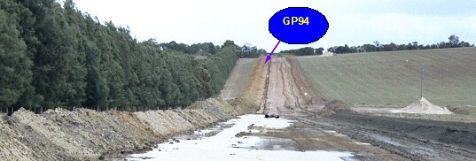 SW94 Landscape |
Soil Profile Morphology:
Surface Soil
| A1 | 0-10 cm | Very dark brown (7.5YR2.5/3 moist) brown (7.5YR5/3 dry); loamy fine sand; pH 5.3: | 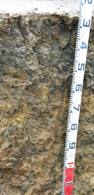 SW94 Profile - Note: Surface (A1) horizon has been stripped from soil profile. |
| A2c | 10-30/50 cm | Light grey to pale brown conspicuously bleached; loamy fine sand; coarse ferruginous gravel present lower in horizon; pH 5.6; sharp and wavy change to: | |
| Subsoil | |||
| B21t | 30/50-60/80 cm | Dark greyish brown (10YR4/2 moist) with fine red mottling; ped interiors sometimes sandy and yellowish brown (10YR5/8 moist); coarse prismatic, parting to medium polyhedral structure; pH 7.4 | |
| B22tg | 60/80+ cm | Pale brown (10YR6/3 moist) with yellowish brown (10YR5/8 moist) and dark red (2.5YR4/8) mottles becoming greyer at depth; sandy clay; pH 9.3. |
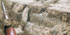
Erosion of exposed pipeline trench during heavy rainfall.
Key Profile Features:
- Very strong texture contrast between surface (A) horizons and subsoil (B21) horizon.
- Large amount of ironstone gravel ("buckshot") in conspicuously bleached subsurface (A2) horizon.
Soil Profile Characteristics:
pH | Salinity Rating | |||
Surface (A1 horizon) | Strongly Acid | Very Low | Non-Sodic | - |
Subsoil (B21 horizon) | Slightly Alkaline | Low | Strongly Sodic | Complete |
Deeper Subsoil (at 100 cm) | Very Strongly Alkaline | Low | Strongly Sodic | Complete |
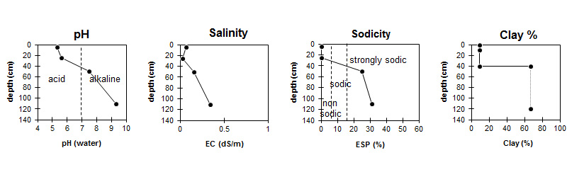
| The surface is strongly acid. The subsoil is slightly alkaline becoming very strongly alkaline at depth. | Salinity rating is very low in the surface and low in the subsoil. | The soil is non sodic in the surface and strongly sodic in the subsoil. | The clay content increases markedly at the A/B boundary. |
Horizon | Sample Depth (cm) | pH (water) | pH (CaCl2) | EC 1:5 | NaCl % | Exchangeable Cations | |||
Ca | Mg | K | Na | ||||||
meq/100g | |||||||||
A1 | 0-10 | 5.3 | 4.6 | 0.07 | 1.8 | 0.47 | 0.17 | 0.16 | |
A2 | 10-40 | 5.6 | 4.8 | <0.05 | 1.2 | 0.43 | 0.1 | 0.17 | |
B21t | 40-60 | 7.5 | 6.2 | 0.16 | 3.8 | 11 | 1.1 | 5.2 | |
B22gt | 100-120 | 9.3 | 8.3 | 0.34 | 0.02 | 3 | 8.4 | 1 | 5.5 |
Horizon | Sample Depth (cm) | Exchangeable Aluminium mg/kg | Exchangeable Acidity meq/100g | Organic Carbon % | Nitrogen % | Field Capacity pF2.5 | Wilting Point pF4.2 | Coarse Sand (0.2- 2.0 mm) | Fine Sand (0.02- 0.2 mm) | Silt (0.002- 0.02 mm) | Clay (<0.002 mm) |
A1 | 0-10 | 17 | 5.9 | 0.97 | 0.08 | 12.8 | 3.7 | 20 | 62 | 7 | 10 |
A2 | 10-40 | <10 | 3.6 | 10.9 | 2.8 | 21 | 62 | 7 | 9 | ||
B21t | 40-60 | 45.6 | 26.1 | 5 | 22 | 3 | 67 | ||||
B22gt | 100-120 |
Management Considerations:
Surface (A) Horizons
- The surface soil is hardsetting and has a very high fine sand content (i.e 62%). When cultivated in a dry condition, the soil will become “powdery: and subsequent rain may form a surface crust.
- The dense and coarsely structured subsoil is strongly sodic and disperses strongly in water. This will result in restricted root growth down the soil profile.
- Very eroded after heavy rain. Soil/land unit mostly transported, generally deep profile > 1 m. Gravel at A2/B21t boundary is a ferruginised weathered and transported sandstone. Some rounded quartz gravel too. Some gravel bands below the B21t.
- Section between the Moorabool River and the Midland Hwy. River flats - Railway: This section of pipe runs up the side of the valley through soils on the Moorabool Viaduct formation. The profile is strongly duplex with a sharp boundary to the dark colored prismatic Bt. The A1 and A2 horizons are very sandy. The gravel present in the lower A2 is consistently 10 to 50 mm, rounded, iron rich, sandstone fragments which have been rounded by transport or weathering. The soil on the slope is transported. Usually it is >1.5 m to the C horizon. B horizon is generally clayey but bands of gravel occur (same gravel as in the A2). Minor presence of rounded quartz (<15 mm and <5%) occurs in the iron rich gravel. This soil is highly erodable and the effect of heavy rain on 12/2/99 was dramatic with washing off the sandy topsoil leaving only residue of gravel perched on the B21t. This gravel was subsequently buried by material from upslope.
- Railway - Midland Highway: Soil developed on the Moorabool Viaduct formation in this section is shallower than between the railway and river. The C horizon is present throughout the trench and soils may be much less than 1.0 m depth (see SW93). C is very sandy with some major pockets of granitic sand probably derived from the Dog Rocks to the GP at the time of formation of Moorabool Viaduct formation.
© State of Victoria (Agriculture Victoria) 1996 - .

This work, Victorian Resources Online, is licensed under a Creative Commons Attribution 4.0 licence. You are free to re-use the work under that licence, on the condition that you credit the State of Victoria (Agriculture Victoria) as author, indicate if changes were made and comply with the other licence terms.
The licence does not apply to ‘branding’ or some ‘images or photographs’ that may be owned by third parties. We ask you to seek prior approval to use images using the VRO feedback form. Access to higher quality images can also be provided on request.
This page was last updated on .