
SW91
Location: Batesford
Australian Soil Classification: Vertic, Hypercalcic, Black CHROMOSOL (moderate profile depth)
General Landscape Description: Gently undulating plain.
Site Description: Flat.
Geology: Newer volcanics
Soil Profile Morphology:
Surface Soil
| Ap | 0-10 cm | Brown (10YR4/3 moist); loam; weak consistence dry; pH 6.8; abrupt change to: | 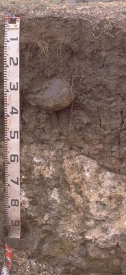 SW91 Profile |
| A12 | 10-30 cm | Very dark grey (10YR3/1 moist); clay loam, fine sandy; very firm consistence dry; medium to coarse (10-30 mm) granular to polyhedral structure; rough faced peds; pH 6.6; clear change to: | |
| Subsoil | |||
| B21tg | 30-50/70 cm | Very dark grey (10YR3/1 moist) to very dark grayish brown (10YR3/2 moist) with dark greyish brown (2.5Y4/2 moist) and reddish brown (5YR4/4 moist) mottles; medium to heavy clay; smooth faced peds; moderate medium (<50 mm) prismatic, parting to coarse (20-50 mm) angular blocky/polyhedral structure; moderately vertic with prominent slickensides at base; strong consistence dry; pH 7.3; sharp and wavy change to: | |
| B22k/R | 50/70-80 cm | Soft whitish carbonate; rounded weathered and fractured basalt; sharp and wavy change to: | |
| R | 80+ cm | Fractured basalt. |
Key Profile Features:
- Strong texture contrast between surface (A) horizons and subsoil (B21) horizon.
- Vertic features (slickensides) in subsoil.
- Calcium carbonate segregations in deeper subsoil.
- Moderate soil profile depth (overlying fractured basalt).
Soil Profile Characteristics:
pH | Salinity Rating | |||
Surface (A1 horizon) | Slightly Acid | Low | Non-Sodic | None |
Subsoil (B21 horizon) | Slightly Alkaline | Very Low | Non-Sodic | None |
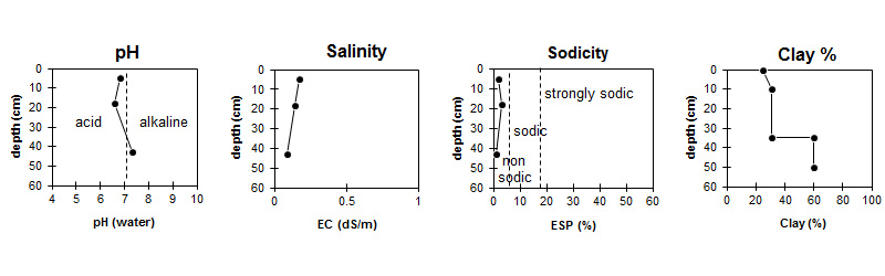
| The surface is slightly acid. The subsoil is slightly alkaline. | Salinity rating is low in the surface and very low in the subsoil. | The soil is non sodic throughout the profile. | The clay content increases markedly at the A/B boundary. |
Horizon | Sample Depth (cm) | pH (water) | pH (CaCl2) | EC 1:5 | Exchangeable Cations | |||
Ca | Mg | K | Na | |||||
meq/100g | ||||||||
A1 | 0-10 | 6.8 | 6.4 | 0.17 | 11 | 4.4 | 0.87 | 0.32 |
A12 | 10-25 | 6.6 | 6 | 0.14 | 12 | 4.2 | 0.7 | 0.41 |
Btg | 35-50 | 7.3 | 6.5 | 0.09 | 22 | 9.3 | 1.1 | 0.33 |
Horizon | Sample Depth (cm) | Organic Carbon % | Nitrogen % | Field Capacity pF2.5 | Wilting Point pF4.2 | Coarse Sand (0.2- 2.0 mm) | Fine Sand (0.02- 0.2 mm) | Silt (0.002- 0.02 mm) | Clay (<0.002 mm) |
A1 | 0-10 | 2.4 | 0.20 | 28.3 | 12.4 | 16 | 36 | 16 | 25 |
A12 | 10-25 | 32 | 15.9 | 8 | 38 | 18 | 31 | ||
Btg | 35-50 | 51.2 | 28.4 | 4 | 20 | 9 | 60 |
Notes:
- Between this site and the Barwon River crossing the soil varies across the plain with small changes in elevation and slope. Calcium carbonate (CaCO3) is ubiquitous and prominent. Soil surface horizons range from nearly black (usually very dark grey) through to dark grey to brown. Sometimes crusting and self-mulching. Soil depth is generally <1.0 m but some small pockets of grey clay >2.0 m, which are strongly vertic, but these are rare occurrences and associated with lower spots, probably silted drainage lines or depressions.
Profile Described By: Richard McEwan (March 1999).
© State of Victoria (Agriculture Victoria) 1996 - .

This work, Victorian Resources Online, is licensed under a Creative Commons Attribution 4.0 licence. You are free to re-use the work under that licence, on the condition that you credit the State of Victoria (Agriculture Victoria) as author, indicate if changes were made and comply with the other licence terms.
The licence does not apply to ‘branding’ or some ‘images or photographs’ that may be owned by third parties. We ask you to seek prior approval to use images using the VRO feedback form. Access to higher quality images can also be provided on request.
This page was last updated on .