
SW89
Location: Mount Pollock
Australian Soil Classification: Endocalcareous, Self-Mulching, Black VERTOSOL
General Landscape Description: Rolling low hills/undulating low hills
Site Description: Upper slope (waning).
Geology: Quaternary-Basalt Newer Volcanics
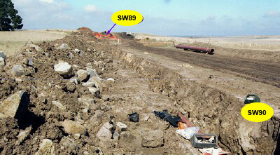 SW89-90 Landscape |
Soil Profile Morphology:
Surface Soil
| A1 | 0-10 cm | Dark brown (7.5YR3/2); self-mulching and cracking surface condition; light clay; very finely pedal; pH 6.8; clear change to: | 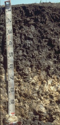 SW89 Profile - Note: A1 horizon stripped from soil profile. |
| Subsoil | |||
| B21t | 10-20 cm | Very dark brown (10YR2/2 moist); light medium clay; fine angular blocky, parting to fine to medium polyhedral structure; smooth faced peds; firm consistence moist; pH 7; clear change to: | |
| B22t(ss) | 20-50/70 cm | Very dark brown (10YR2/2 moist), with few brown (7.5YR5/4 moist) mottles; medium to heavy clay; angular blocky, parting to coarse lenticular structure; obvious and frequent slickensides; strong consistence dry; pH 7.8; abrupt and wavy change to: | |
| B23k/R | 50/70+ cm | Brown (7.5YR4/3 moist); >50% soft carbonate in clay matrix; fragments of hard basalt grading into continuous fractured basalt; pH 8.6. |
Key Profile Features:
- High (>35%) clay content throughout the profile.
- Strong cracking occurs when dry.
- Vertic features (i.e. lenticular peds and slickensides) in subsoil.
- Calcium carbonate segregations in deeper subsoil.
Soil Profile Characteristics:
pH | Salinity Rating | |||
Surface (A1 horizon) | Slightly Acid | Low | Non-Sodic | None1 |
Subsoil (B21 horizon) | Neutral | Low | Non-Sodic | None1 |
Deeper Subsoil (at 80-90 cm) | Strongly Alkaline | Low | Slightly Sodic | None |
| 1 Slight-moderate dispersion after remoulding. | ||||
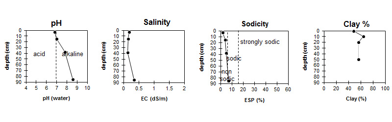
| The surface is slightly acid. The subsoil is neutral becoming strongly alkaline at depth. | Salinity rating is low throughout the profile. | The soil is non sodic in the surface and upper subsoil becoming slightly sodic at depth. | Clay levels are quite high throughout the profile. |
Horizon | Sample Depth (cm) | pH (water) | pH (CaCl2) | EC 1:5 | NaCl % | Exchangeable Cations | |||
Ca | Mg | K | Na | ||||||
meq/100g | |||||||||
A1 | 0-5 | 6.8 | 6.2 | 0.18 | 21 | 13 | 1.5 | 0.73 | |
B21t | 10-20 | 7 | 6.2 | 0.15 | 22 | 17 | 1.3 | 1.3 | |
B22t(ss) | 30-45 | 7.8 | 7.8 | 0.14 | 23 | 17 | 0.77 | 1.9 | |
B23k | 80-90 | 8.6 | 7.9 | 0.34 | 0.01 | 26 | 21 | 0.5 | 3.1 |
Horizon | Sample Depth (cm) | Organic Carbon % | Nitrogen % | Field Capacity pF2.5 | Wilting Point pF4.2 | Coarse Sand (0.2- 2.0 mm) | Fine Sand (0.02- 0.2 mm) | Silt (0.002- 0.02 mm) | Clay (<0.002 mm) |
A1 | 0-5 | 3.4 | 0.31 | 47.2 | 28.8 | 7 | 15 | 19 | 49 |
B21t | 10-20 | 60.9 | 35.8 | 4 | 11 | 12 | 64 | ||
B22t(ss) | 30-45 | 61.7 | 34.9 | 4 | 13 | 18 | 56 | ||
B23k | 80-90 | 69.2 | 41.6 |
Management Considerations:
Surface (A) Horizons
- The surface soil is self-mulching which will result in a seed bed that is friable and easily worked.
- The relatively high wilting point (i.e. 28%) indicates that plants will be unable to fully utilise light rains, when the soil is dry.
- Tillage of cracking clay soils should be avoided if the soil is wet (i.e. wetter than the plastic limit). At such moisture conditions, excessive tillage, trafficking or over stocking could result in structural damage (i.e. compaction, smearing) occurring. Ideally tillage and trafficking should take place when the soil is drier than the plastic limit.
- When the soil is dry, heavy rains will move from soil cracks. This rapid recharge can be valuable for the survival of plants near wilting. When wet, the soil will swell and further infiltration of water will be relatively slow.
Profile Described By: Richard McEwan (March1999).
© State of Victoria (Agriculture Victoria) 1996 - .

This work, Victorian Resources Online, is licensed under a Creative Commons Attribution 4.0 licence. You are free to re-use the work under that licence, on the condition that you credit the State of Victoria (Agriculture Victoria) as author, indicate if changes were made and comply with the other licence terms.
The licence does not apply to ‘branding’ or some ‘images or photographs’ that may be owned by third parties. We ask you to seek prior approval to use images using the VRO feedback form. Access to higher quality images can also be provided on request.
This page was last updated on .