
SW60
Location: Simpson.
Australian Soil Classification: Reticulate, Mesotrophic, Brown CHROMOSOL.
General Landscape Description: A plateau of dissected Tertiary sediments within a gently undulating plain.
Site Description: Level to slightly sloping crest.
Geology: Hanson Plain Sand.
Land Use: Dairy cattle grazing.
Soil Profile Morphology:
Surface Soil
| Ah | 0-25 cm | Very dark greyish brown (10YR3/2); sandy loam; weak fine to medium polyhedral structure; pH 6.2; abrupt and smooth boundary to: | 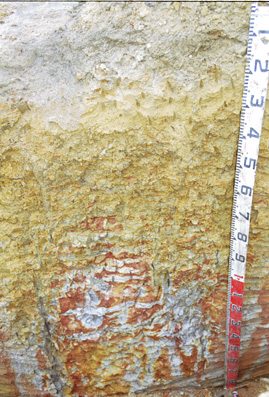 SW60 Profile. NOTE: Reticulate Mottling or "Tiger Mottling" in subsoil. |
| Subsoil | |||
| B21 | 25-40 cm | Brownish yellow (10YR6/8); sandy clay loam; massive; pH 6.0; clear and wavy change to: | |
| B22t | 40-70/90 cm | Light olive brown (2.5Y5/3) with yellowish brown (10YR5/6) mottles with red (2.5YR5/8) ped interiors; medium clay; fine to coarse polyhedral structure; smooth ped faces; very firm consistence dry; pH 5.8; irregular and clear change to: | |
| B/C | 70/90+ cm | Light grey (2.5Y7/1) with yellowish brown (10YR5/8) and yellowish red (5YR5/6) ped interiors, with conspicuous coarse (50-100 mm in size) reticulate mottling; very coarse to coarse (30-100 mm in size) polyhedral, parting to medium to fine (5-30 mm in size) polyhedral structure; smooth faced peds; pH 5.5. | |
Key Profile Features:
- Strong texture contrast between surface (A) horizons and subsoil (B21) horizon.
Soil Profile Characteristics:
pH | Salinity Rating | |||
Surface (A1 horizon) | Slightly Acid | Low | Non-Sodic | None |
Subsoil (B21 horizon) | Moderately Acid | Very Low | Non-Sodic | None |
Deeper subsoil (at 80+ cm) | Strongly Acid | Very Low | Non-Sodic | None |
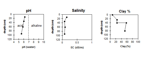
This surface is slightly acid. The subsoil is moderately acid becoming strongly acid at depth. | This salinity rating in the surface is low. The subsoil is very low. | The clay content increases markedly at the surface / subsoil boundary. |
Horizon | Horizon Depth (cm) | pH (water) | pH (CaCl2) | EC (dS/m) | Exchangeable Cations | |||
Ca | Mg | K | Na | |||||
meq/100g | ||||||||
A1 | 0-25 | 6.2 | 5.6 | 0.15 | 6.2 | 0.55 | 0.51 | 0.18 |
A2 | 25-40 | 6 | 5.4 | 0.08 | 1.8 | 0.92 | 0.24 | 0.09 |
B21 | 40-80 | 5.8 | 5.6 | 0.09 | 1.7 | 5 | 0.45 | 0.25 |
B22 | 80-105 | 5.5 | 5.1 | 0.08 | 0.82 | 4.7 | 0.17 | 0.33 |
Horizon | Horizon Depth (cm) | Oxidisable Organic Carbon % | Total Nitrogen % | Exchangeable Aluminium mg/kg | Exchangeable Acidity meq/100g | Field Capacity pF2.5 | Wilting Point pF4.2 | Coarse Sand (0.2-2.0 mm) | Fine Sand (0.02-0.2 mm) | Silt (0.002-0.02 mm) | Clay (<0.002 mm) |
A1 | 0-25 | 3.1 | 0.25 | <10 | 9.3 | 18 | 7 | 29 | 46 | 12 | 8 |
A2 | 25-40 | <10 | 4.3 | 16 | 9 | 27 | 41 | 8 | 24 | ||
B21 | 40-80 | <10 | 8 | 33 | 24 | 15 | 18 | 6 | 58 | ||
B22 | 80-105 | <10 | 6.8 | 32 | 21 | 25 | 16 | 4 | 52 |
Management Considerations:
Subsoil (B) Horizons
- The low exchangeable calcium:magnesium ratio in the subsoil (0.4 in B21, 0.2 in B22) indicates that nutrient imbalances may occur e.g. calcium deficiency.
© State of Victoria (Agriculture Victoria) 1996 - .

This work, Victorian Resources Online, is licensed under a Creative Commons Attribution 4.0 licence. You are free to re-use the work under that licence, on the condition that you credit the State of Victoria (Agriculture Victoria) as author, indicate if changes were made and comply with the other licence terms.
The licence does not apply to ‘branding’ or some ‘images or photographs’ that may be owned by third parties. We ask you to seek prior approval to use images using the VRO feedback form. Access to higher quality images can also be provided on request.
This page was last updated on .