
SW58
Location: Cooriemungle.
Australian Soil Classification: Humose, Kurosolic, Redoxic HYDROSOL
Site Description: Drained dairy grazing paddock.
General Landscape Description: Flat valley floor in dissected plain.
Geology: Quaternary alluvium derived from Gellibrand Marl and Hanson Plain Sand.
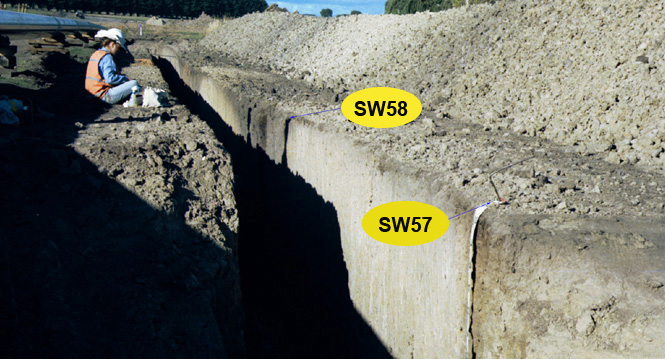 SW58 Landscape |
Soil Profile Morphology:
Surface Soil
| A1 | 0-30 cm | Very dark brown (10YR2/2); clay loam; weak medium polyhedral structure; weak consistence dry; pH 5.9; clear and smooth change to: | 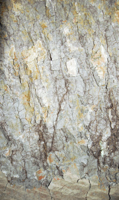 SW58 Profile. Note: Surface (A1) has been stripped from the soil profile. |
| Subsoil | |||
| B21 | 30-45 cm | Black (10YR2/1) with reddish yellow (5YR6/8) mottles common, mainly in root channels; medium clay; coarse polyhedral, parting to medium blocky structure; weak consistence dry; pH 5.3; abrupt and smooth change to: | |
| B22g | 45-75 cm | Dark grey (10YR4/1) with brownish yellow (10YR6/8) mottles common; medium clay; medium prismatic, parting to medium blocky structure; firm consistence dry; pH 5.5; clear and smooth change to: | |
| B23g | 75+ cm | Grey (10YR5/1) with many reddish yellow (7.5YR6/8) mottles; heavy clay; very coarse prismatic structure (larger at depth) parting to coarse blocky structure; very firm consistence dry; pH 5.8; strong sulphidic smell i.e. anaerobic. | |
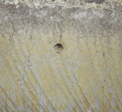
Drainage hole in profile.
Key Profile Features:
- Strong texture contrast between surface (A1) horizon and subsoil (B21) horizon.
Soil Profile Characteristics:
pH | Salinity Rating | |||
Surface (A1 horizon) | Moderately Acid | Low | Non-Sodic | None |
Subsoil (B21 horizon) | Strongly Acid | Low | Non-Sodic | None |
Deeper Subsoil (at 75-130 cm) | Moderately Acid | Low | Non-Sodic | None |
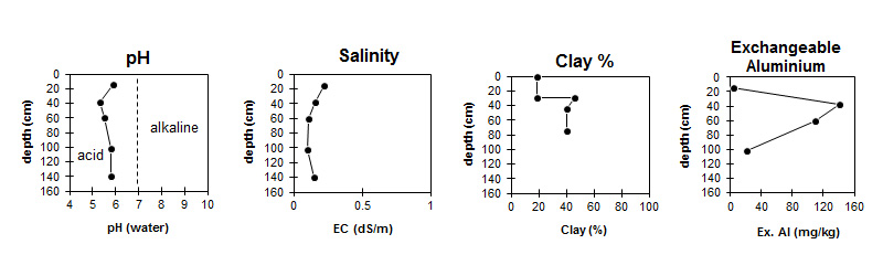
| The surface is moderately acid. The subsoil is strongly acid. | The salinity rating is low throughout the profile. | The clay content increases markedly at the surface / subsoil boundary. | Exchangeable Aluminium increases to very high levels in the subsoil. |
Horizon | Horizon Depth (cm) | pH (water) | pH (CaCl2) | EC (dS/m) | Exchangeable Cations | |||
Ca | Mg | K | Na | |||||
meq/100g | ||||||||
A1 | 0-30 | 5.9 | 5.4 | 0.22 | 12 | 2.8 | 0.4 | 0.46 |
B21 | 30-45 | 5.3 | 4.5 | 0.16 | 8.2 | 5.2 | 0.38 | 0.8 |
B22 | 45-75 | 5.5 | 4.6 | 0.11 | 5.1 | 5.2 | 0.34 | 0.71 |
B23g | 75-130 | 5.8 | 4.8 | 0.1 | 3.4 | 3.8 | 0.23 | 0.54 |
B23g | 130-150 | 5.8 | 5 | 0.15 | ||||
Horizon | Horizon Depth (cm) | Oxidisable Organic Carbon % | Total Nitrogen % | Exchangeable Aluminium mg/kg | Exchangeable Acidity meq/100g | Field Capacity pF2.5 | Wilting Point pF4.2 | Coarse Sand (0.2-2.0 mm) | Fine Sand (0.02-0.2 mm) | Silt (0.002-0.02 mm) | Clay (<0.002 mm) |
A1 | 0-30 | 4.8 | 0.4 | <10 | 13 | 36 | 15 | 5 | 46 | 21 | 19 |
B21 | 30-45 | 140 | 18 | 39 | 22 | 5 | 20 | 21 | 46 | ||
B22 | 45-75 | 110 | 12 | 36 | 24 | 9 | 28 | 20 | 40 | ||
B23g | 75-130 | 22 | 5.4 | 25 | 13 | 13 | 39 | 23 | 26 | ||
B23g | 130-150 |
Management Considerations:
Whole Profile
- The soil profile will be saturated for a number of months during most years. Drainage will be required for agricultural use.
- An additional subsoil horizon was sampled 10 m west of profile called SW57 to ensure adequate coverage of soil variability at this site.
- Exchangeable aluminium levels are reasonably high in the strongly acid upper subsoil. This may restrict the growth of aluminium sensitive species.
Profile Described By: Mark Imhof and Richard MacEwan (April 1999).
© State of Victoria (Agriculture Victoria) 1996 - .

This work, Victorian Resources Online, is licensed under a Creative Commons Attribution 4.0 licence. You are free to re-use the work under that licence, on the condition that you credit the State of Victoria (Agriculture Victoria) as author, indicate if changes were made and comply with the other licence terms.
The licence does not apply to ‘branding’ or some ‘images or photographs’ that may be owned by third parties. We ask you to seek prior approval to use images using the VRO feedback form. Access to higher quality images can also be provided on request.
This page was last updated on .