
SW55
Location: Cooriemungle.
Australian Soil Classification: Melacic, Sesquic, Semiaquic PODOSOL
Great Soil Group: podzol.
General Landscape Description: Convex rise on valley floor within a dissected plain.
Geology: Quaternary alluvium derived from Hanson Plain Sand.
Land Use: Dairy cattle grazing.
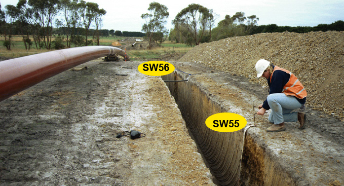 SW55 Landscape. |
Soil Profile Morphology:
Surface Soil
| A1 | 0-10 | Black (10YR2/1); sandy loam; weak fine to medium polyhedral structure; weak consistence dry; abrupt and smooth change to: | 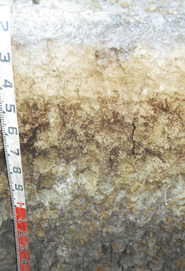 SW55 profile. Note: Surface (A) horizon has been stripped from the soil profile. |
| A2 | 10-20 cm | Dark greyish brown (10YR4/2) conspicuously bleached (10YR8/1 dry); fine sandy clay loam; massive; weak consistence dry; abrupt and wavy change to: | |
| Subsoil | |||
| B21s | 20-50 cm | Dark yellowish brown (10YR4/4); light sandy clay; massive; weak to firm consistence dry; clear and wavy change to: | |
| B22s(h) | 50-80 cm | Brownish yellow (10YR6/6) and brown (10YR4/3) with very dark grey (7.5YR3/1) on exterior of peds and in root channels; medium heavy clay; coarse polyhedral, parting to medium polyhedral structure; firm consistence dry: | |
| B23g | 80 cm+ | Grey (10YR5/1) with yellowish brown (10YR5/6) and red (2.5YR5/8) mottles common in interior of peds; dark grey to black coatings on ped faces and in root channels; medium heavy clay; coarse blocky, parting to medium polyhedral structure. |
NOTE: Pit site not sampled for chemical analysis.
Profile Described By: Mark Imhof and Richard MacEwan (April 1999).
© State of Victoria (Agriculture Victoria) 1996 - .

This work, Victorian Resources Online, is licensed under a Creative Commons Attribution 4.0 licence. You are free to re-use the work under that licence, on the condition that you credit the State of Victoria (Agriculture Victoria) as author, indicate if changes were made and comply with the other licence terms.
The licence does not apply to ‘branding’ or some ‘images or photographs’ that may be owned by third parties. We ask you to seek prior approval to use images using the VRO feedback form. Access to higher quality images can also be provided on request.
This page was last updated on .