
SW54
Location: Cooriemungle.
Australian Soil Classification: Acidic, Eutrophic, Grey DERMOSOL.
General Landscape Description: Gleyed soil on an alluvial fan at the toe slope of a landslide.
Geology: Quaternary alluvium derived from Gellibrand Marl.
Land Use: Dairy cattle grazing.
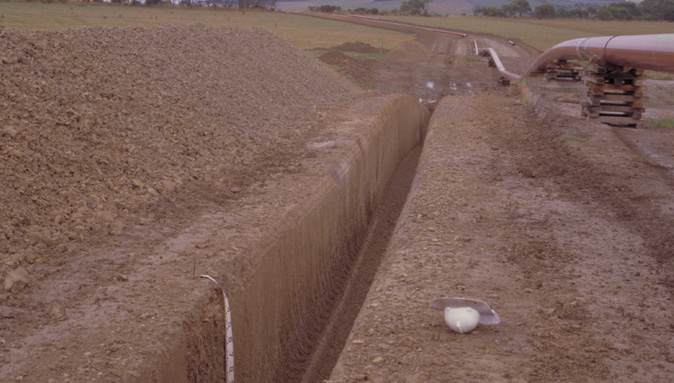 SW54 Landscape. |
Soil Profile Morphology:
Surface Soil
| A1 | 0-15 cm | Very dark greyish brown (10YR3/2); fine sandy loam; weak medium polyhedral structure; pH 5.7: abrupt and smooth change to: | 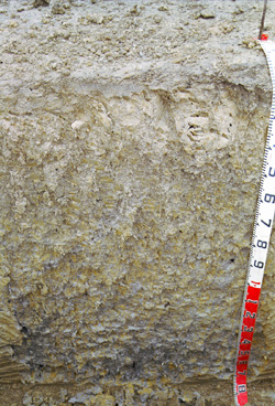 SW54 profile. Note: Surface (A) horizon has been stripped from the soil profile. |
| A2 | 15-35 cm | Grey (2.5Y6/1) conspicuously bleached (2.5Y7/2 dry); clay loam; apedal; strong consistence dry; pH 5.4; abrupt and smooth change to: | |
| Subsoil | |||
| B21g | 35-80 cm | Grey (2.5Y5/1) with yellowish brown (10YR5/6) mottles common; light clay; fine polyhedral structure; very firm consistence dry; pH 5.2; diffuse and smooth change to: | |
| B22g | 80-130 cm | Grey (2.5Y5/1) with many yellowish brown (10YR5/6) mottles; medium clay; coarse polyhedral or angular blocky, parting to coarse polyhedral structure; pH 5.2; diffuse and smooth change to: | |
| B23gss | 130 cm+ | Dark grey (2.5Y4/1) with a few yellowish brown (10YR5/6) mottles; medium heavy clay; coarse polyhedral or angular blocky, parting to coarse polyhedral structure; slickensides (up to 100 mm); pH 5.4. |
Key Profile Features:
- Gradual increase in clay content down the soil profile.
Soil Profile Characteristics:
pH | Salinity Rating | |||
Surface (A1 horizon) | Moderately Acid | Medium | Non-Sodic | None |
Subsoil (B21 horizon) | Strongly Acid | Low-Medium | Sodic | None |
Deeper Subsoil (at 80+ cm) | Strongly Acid | Low | Sodic | None |
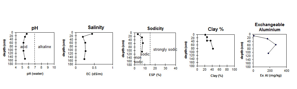
| The surface is moderately acid. The subsoil is strongly acid. | Salinity rating is medium in the surface. The upper subsoil is low to medium becoming low at depth. | The surface is non-sodic the subsoil is sodic. | Clay content increases markedly at the surface / subsoil boundary. | Exchangeable Aluminium increases to very high levels in the subsoil. |
Horizon | Horizon Depth (cm) | pH (water) | pH (CaCl2) | EC (dS/m) | NaCl % | Exchangeable Cations | |||
Ca | Mg | K | Na | ||||||
meq/100g | |||||||||
A1 | 0-15 | 5.7 | 5.1 | 0.44 | 0.09 | 8.3 | 3.7 | 0.6 | 0.8 |
A2 | 15-35 | 5.4 | 4.5 | 0.19 | 2.7 | 3.2 | 0.44 | 1.2 | |
B21 | 35-80 | 5.2 | 4.4 | 0.25 | 3.2 | 4.9 | 0.41 | 1.6 | |
B22 | 80-130 | 5.2 | 4.4 | 0.26 | 0.06 | 3.7 | 6.5 | 0.2 | 1.5 |
B23 | 130+ | 5.4 | 4.5 | 0.23 | |||||
Horizon | Horizon Depth (cm) | Oxidisable Organic Carbon % | Total Nitrogen % | Exchangeable Aluminium mg/kg | Exchangeable Acidity meq/100g | Field Capacity pF2.5 | Wilting Point pF4.2 | Coarse Sand (0.2-2.0 mm) | Fine Sand (0.02-0.2 mm) | Silt (0.002-0.02 mm) | Clay (<0.002 mm) |
A1 | 0-15 | 4.3 | 0.37 | <10 | 14 | 42 | 16 | 7 | 31 | 27 | 22 |
A2 | 15-35 | 170 | 10 | 29 | 12 | 2 | 44 | 25 | 26 | ||
B21 | 35-80 | 270 | 11 | 32 | 32 | 2 | 40 | 21 | 36 | ||
B22 | 80-130 | 180 | 9.2 | 15 | 17 | 1 | 35 | 19 | 42 | ||
B23 | 130+ |
Management Considerations:
Whole Profile
- The high exchangeable aluminium levels measured in the strongly acid soil profile (below surface horizon) are likely to restrict the growth of aluminium sensitive species.
- The subsoil is slightly sodic but does not disperse. The high levels of exchangeable aluminium are likely to prevent dispersion occurring.
Profile Described By: Mark Imhof and Richard MacEwan (March 1999).
© State of Victoria (Agriculture Victoria) 1996 - .

This work, Victorian Resources Online, is licensed under a Creative Commons Attribution 4.0 licence. You are free to re-use the work under that licence, on the condition that you credit the State of Victoria (Agriculture Victoria) as author, indicate if changes were made and comply with the other licence terms.
The licence does not apply to ‘branding’ or some ‘images or photographs’ that may be owned by third parties. We ask you to seek prior approval to use images using the VRO feedback form. Access to higher quality images can also be provided on request.
This page was last updated on .