
SW53
Location: Cooriemungle.
Australian Soil Classification: Vertic (& Sodic), Calcic, Grey CHROMOSOL
Geology: Gellibrand Marl.
Land Use: Dairy cattle grazing.
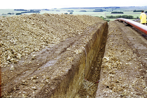 SW53 Landscape. |
Soil Profile Morphology:
Surface Soil
| A1 | 0-15 cm | Very dark greyish brown (10YR3/2); silty clay loam; weakly pedal; fine to medium polyhedral structure; pH 5.7; abrupt and smooth change to: | 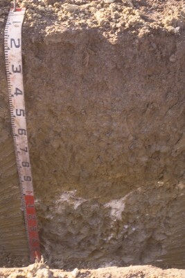 SW53 profile. Note: Surface (A) horizon has been stripped from the soil profile. |
| Subsoil | |||
| B21g | 15-60/70 cm | Dark greyish brown (2.5Y4/2) with common yellowish brown (10YR5/8) mottles; medium clay; coarse polyhedral, parting to fine to medium polyhedral structure; pH 5.7; gradual and wavy change to: | |
| B22g | 60/70-105/115 cm | Light olive brown (2.5Y5/4) and grey (2.5Y5/1); medium to heavy clay; coarse polyhedral or angular blocky, parting to fine to medium polyhedral structure; slickensides (>20 mm in size); pH 7.4; abrupt and irregular change to: | |
| B23kgss | 105/115-160+ cm | Light olive grey (5Y6/2) with common yellowish brown (10YR5/8) mottles; heavy clay; very coarse angular blocky, parting to coarse polyhedral or angular blocky, and fine to mediumlenticular structure; soft white extremely coarse (100 mm in size) calcareous accumulations at top of horizon; slickensides (>100 mm); pH 8.9. | |
Key Profile Features:
- Strong texture contrast between surface (A) horizon and subsoil (B21) horizon.
- Vertic properties (slickensides present) in deeper subsoil.
Soil Profile Characteristics:
pH | Salinity Rating | |||
Surface (A1 horizon) | Moderately Acid | Low | Non-Sodic | None |
Subsoil (B21 horizon) | Moderately Acid | Low | Non-Sodic | None |
Deeper Subsoil (at 70- 105 cm) | Slightly Alkaline | Low | Sodic | Strong1 |

| The surface and upper subsoil is moderately acid. The subsoil at 1 metre is slightly alkaline becoming strongly alkaline at depth. | Salinity rating is low down to 1 metre and increases to medium at depth. | The surface and upper subsoil is non-sodic becoming sodic in the deeper subsoil. | Clay content increases markedly at the surface / subsoil boundary. | Exchangeable Aluminium increases to very high levels in the subsoil. |
Horizon | Horizon Depth (cm) | pH (water) | pH (CaCl2) | EC (dS/m) | NaCl % | Exchangeable Cations | |||
Ca | Mg | K | Na | ||||||
meq/100g | |||||||||
A1 | 0-15 | 5.7 | 4.9 | 0.11 | 8.8 | 3.8 | 0.63 | 0.48 | |
B21 | 15-60/70 | 5.7 | 4.5 | 0.1 | 8.5 | 9.4 | 0.51 | 1.2 | |
B22 | 60/70-105/115 | 7.4 | 6.2 | 0.16 | 16 | 13 | 0.43 | 3.2 | |
B23 | 105/115-160 | 8.9 | 8.9 | 0.77 | 0.09 | 16 | 14 | 2.9 | 5.8 |
Horizon | Horizon Depth (cm) | Oxidisable Organic Carbon % | Total Nitrogen % | Exchangeable Aluminium mg/kg | Exchangeable Acidity meq/100g | Field Capacity pF2.5 | Wilting Point pF4.2 | Coarse Sand (0.2-2.0 mm) | Fine Sand (0.02-0.2 mm) | Silt (0.002-0.02 mm) | Clay (<0.002 mm) |
A1 | 0-15 | 4.2 | 0.3 | 13 | 15 | 39 | 17 | 7 | 25 | 30 | 27 |
B21 | 15-60/70 | 240 | 13 | 45 | 24 | 1 | 17 | 19 | 59 | ||
B22 | 60/70-105/115 | 53 | 26 | 1 | 12 | 18 | 65 | ||||
B23 | 105/115-160 |
Management Considerations:
Surface (A) Horizon
- In its natural state the surface soil is well structured and strongly pedal. The description here "weakly pedal" is a reflection of the damaged caused by pugging, a common winter effect in the Heytsbury district.
- The level of exchangeable aluminium measured in this horizon is high. This may restrict the growth of aluminium sensitive species.
Profile Described By: Mark Imhof and Richard MacEwan (March 1999).
© State of Victoria (Agriculture Victoria) 1996 - .

This work, Victorian Resources Online, is licensed under a Creative Commons Attribution 4.0 licence. You are free to re-use the work under that licence, on the condition that you credit the State of Victoria (Agriculture Victoria) as author, indicate if changes were made and comply with the other licence terms.
The licence does not apply to ‘branding’ or some ‘images or photographs’ that may be owned by third parties. We ask you to seek prior approval to use images using the VRO feedback form. Access to higher quality images can also be provided on request.
This page was last updated on .