
SW42
Location: Cobden
Australian Soil Classification: Melacic-Mottled (& Vertic), Eutrophic, Brown CHROMOSOL (thick clay loamy surface).
Map Unit: Map Unit 20 (Maher and Martin, 1987).
General Landscape Description: Upper slope of gently undulating rise.
Site Description: Grazing paddock (dairy).
Geology: Tertiary - Gellibrand Marl
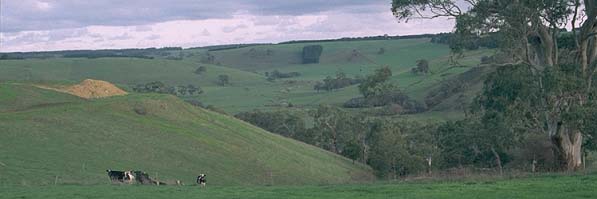 SW42 Landscape |
Soil Profile Morphology:
Surface Soil
| A1 | 0-30 cm | Very dark greyish brown (10YR3/2); clay loam (very fine sandy); moderate coarse blocky, parting to moderate medium polyhedral and moderate fine polyhedral structure; weak consistence moist; pH 5.3: | 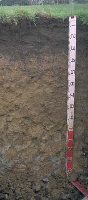 SW42 profile |
| A2 | 30-35 cm | Brown (10YR5/3); clay loam; discontinuous and clear change to: | |
| Subsoil | |||
| B21 | 35-60 cm | Yellowish brown (10YR5/4) with many (30%) brownish yellow (10YR6/6) mottles; medium clay; strong medium blocky, parting to strong fine blocky and lenticular structure; some slickensides present; contains few (5%) very coarse (2-5cm) iron nodules in patches; weak consistence moist; pH 6.5: | |
| B22 | 60-80 cm | Light olive brown (2.5Y5/4) with many brownish yellow (10YR6/6) mottles; medium clay; lenticular structure; weak consistence moist; pH 6.8: | |
| B23 | 80-110 cm | Light olive brown (2.5Y5/4) with many brownish yellow (10YR6/6) mottles; medium clay; moderate very coarse prismatic, parting to moderate coarse blocky structure; large slickensides present; very firm consistence moist; pH 6.9: | |
| B3 | 110+ cm | Grey (N5) with brownish yellow (10YR6/8) and some red mottles; medium clay; large slickensides present; very firm consistence moist; pH 6.8. | |
Key Profile Features:
- Strong texture contrast between surface (A) horizon and subsoil (B21) horizon.
Soil Profile Characteristics:
pH | Salinity Rating | |||
Surface (A1 horizon) | Strongly Acid | Low | Non-Sodic | None |
Subsoil (B21 horizon) | Slightly Acid | Very Low | Non-Sodic | None |
Deeper Subsoil (at 1 m) | Slightly Acid | Low | Sodic | Slight1 |
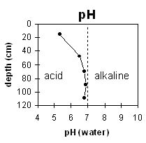 | 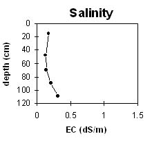 |
The surface horizon is strongly acid. The subsoil is slightly acid. | The salinity rating is low throughout the profile. |
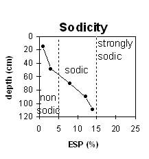 | 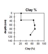 |
The surface and upper subsoil is non-sodic. The subsoil becomes sodic at about 60 cm depth. | The clay content increases markedly at 35 cm depth. |
Horizon | Horizon Depth (cm) | pH (water) | pH CaCl2 | EC (dS/m) | NaCl % | Exchangeable Cations | |||
Ca | Mg | K | Na | ||||||
meq/100g | |||||||||
A1 | 0-30 | 5.3 | 4.7 | 0.17 | 7.4 | 1.5 | 0.4 | 0.05 | |
A2 | 30-35 | ||||||||
B21 | 35-60 | 6.5 | 5.7 | 0.13 | 9.5 | 6.2 | 0.2 | 0.7 | |
B22 | 60-80 | 6.8 | 6 | 0.14 | 8.8 | 7 | 0.2 | 1.4 | |
B23 | 80-110 | 6.9 | 6.2 | 0.21 | 10 | 7.8 | 0.1 | 2.4 | |
B3 | 110+ | 6.8 | 6 | 0.31 | 0.04 | 9 | 7.1 | 0.1 | 2.7 |
Horizon | Horizon Depth (cm) | Acidity meq/100g | Oxidisable Organic Carbon % | Total Nitrogen % | Field Capacity pF2.5 | Wilting Point pF4.2 | Coarse Sand (0.2-2.0 mm) | Fine Sand (0.02-0.2 mm) | Silt (0.002-0.02 mm) | Clay (<0.002 mm) |
A1 | 0-30 | 4.0 | 0.29 | 37.6 | 17.2 | 8 | 34 | 16 | 22 | |
A2 | 30-35 | |||||||||
B21 | 35-60 | 10 | 51.8 | 29.2 | 6 | 16 | 7 | 64 | ||
B22 | 60-80 | 53.9 | 30 | 4 | 14 | 6 | 68 | |||
B23 | 80-110 | 57.8 | 30.5 | 3 | 14 | 7 | 69 | |||
B3 | 110+ | 48.4 | 26.6 | 17 | 16 | 8 | 54 |
Profile Described By: Mark Imhof and Austin Brown (June 1998).
© State of Victoria (Agriculture Victoria) 1996 - .

This work, Victorian Resources Online, is licensed under a Creative Commons Attribution 4.0 licence. You are free to re-use the work under that licence, on the condition that you credit the State of Victoria (Agriculture Victoria) as author, indicate if changes were made and comply with the other licence terms.
The licence does not apply to ‘branding’ or some ‘images or photographs’ that may be owned by third parties. We ask you to seek prior approval to use images using the VRO feedback form. Access to higher quality images can also be provided on request.
This page was last updated on .