
SW13
Location: Lake Corangamite
Australian Soil Classification: Endocalcareous, Self-Mulching, Black VERTOSOL
General Landscape Description: Lunette.
Site Description: Upper mid slope. Weak gilgai evident.
Landuse: Pasture grazing – sheep and beef.
Geology: Quaternary aeolian deposits derived from lake bed sediments.
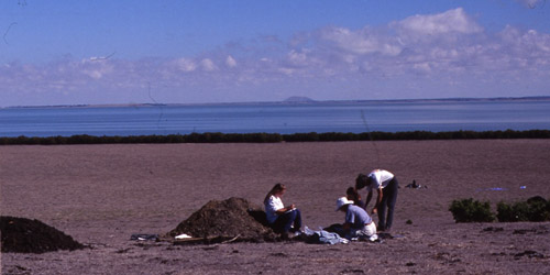
SW13 Landscape – view downslope from SW14 towards the lower slope and terrace of the lunette.
Soil Profile Morphology:
Surface Soil
| A11 | 0-4 cm | Black (N2.5/0); surface self mulching and cracking; silty clay; very fine polyhedral structure; pH 7.8; clear and smooth change to: | 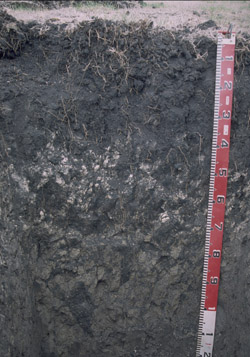 |
| A12 | 4-15 cm | Black (N2.5/0); silty clay; coarse polyhedral, parting to fine polyhedral structure; very firm consistence dry; contains an abundant amount of fine sized roots; pH 8.1; clear and smooth change to: | |
| Subsoil | |||
| B21kt | 15-30 cm | Black (N2.5/0); light medium clay; coarse prismatic, parting to coarse angular blocky, parting to very fine polyhedral structure; contains very few (<5%) carbonate segregations; faint slickensides evident; slightly calcareous; pH 8.5; gradual and smooth change to: | |
| B22kt | 30-60 cm | Dark grey (N4/0); medium clay; coarse prismatic, parting to coarse angular blocky, parting to very fine polyhedral structure; strong consistence dry; contains a common (10-20%) amount of soft, pinkish grey coloured (5YR7/2) carbonate segregations; very fine slickensides evident; pH 9.2; gradual and wavy change to: | |
| B3 | 60-100 cm | Olive grey (5YR5/2); light clay; coarse prismatic parting to polyhedral structure; contains shell fragments; contains fine (2 mm in diameter) roots; very fine pores present; pH 9.6. | |
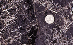
Cracking and self-mulching surface condition.
Soil Profile Characteristics:
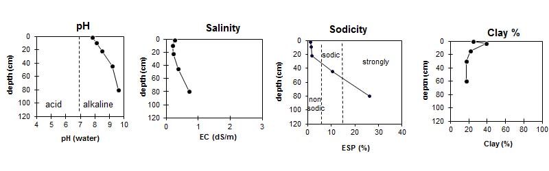
pH | Salinity Rating | |||
Surface (A1 horizon) | Slightly Alkaline | Low to Medium | Non Sodic | None |
Subsoil (B21 horizon) | Moderately Alkaline | Low to Medium | Sodic | None |
Deeper Subsoil (at 60-100 cm) | Extremely Alkaline | Very High | Strongly Sodic | None1 |
|
|
|
|
Horizon | Horizon Depth (cm) | pH (water) | pH (CaCl2) | EC ds/m | NaCl % | Exchangeable Cations | |||
Ca | Mg | K | Na | ||||||
meq/100g | |||||||||
A11 | 0-4 | 7.8 | 7.4 | 0.27 | <0.05 | 27 | 35 | 3.1 | 0.85 |
A12 | 4-15 | 8.1 | 7.6 | 0.21 | 29 | 37 | 2.1 | 0.98 | |
B21kt | 15-30 | 8.5 | 7.9 | 0.22 | 34 | 47 | 1.5 | 1.5 | |
B22 | 30-60 | 9.2 | 8.5 | 0.38 | <0.05 | 3.5 | 32 | 1.7 | 4.3 |
B3kt | 60-100 | 9.6 | 8.5 | 0.71 | <0.05 | 0.8 | 28 | 2.2 | 11 |
Horizon | Horizon Depth (cm) | Total Nitrogen g/100g | Organic Carbon % | Wilting Point pF4.2 | Coarse Sand (0.2- 2.0 mm) | Fine Sand (0.02- 0.2 mm) | Silt (0.002- 0.02 mm) | Clay (<0.002 mm) |
A11 | 0-4 | 0.39 | 4.7 | 40 | 2 | 20 | 35 | 25 |
A12 | 4-15 | 39 | 0 | 12 | 29 | 39 | ||
B21 | 15-30 | 41 | 0 | 25 | 30 | 22 | ||
B22 | 30-60 | 35 | 0 | 25 | 23 | 17 | ||
B3 | 60-100 | 0 | 26 | 25 | 18 |
Profile Described By: Richard MacEwan, John Martin, Mark Imhof (March 1997).
© State of Victoria (Agriculture Victoria) 1996 - .

This work, Victorian Resources Online, is licensed under a Creative Commons Attribution 4.0 licence. You are free to re-use the work under that licence, on the condition that you credit the State of Victoria (Agriculture Victoria) as author, indicate if changes were made and comply with the other licence terms.
The licence does not apply to ‘branding’ or some ‘images or photographs’ that may be owned by third parties. We ask you to seek prior approval to use images using the VRO feedback form. Access to higher quality images can also be provided on request.
This page was last updated on .