
SW100
Location: Batesford
Australian Soil Classification: Calcic, Hypernatric, Brown SODOSOL
General Landscape Description: Undulating rises.
Site Description: Open depression.
Geology: Moorabool Viaduct alluvium.
Soil Profile Morphology:
Surface Soil
| Ap | 0-25 cm | Reddish yellow mottled; sand; hardsetting (recently deposited material); abrupt change to: | 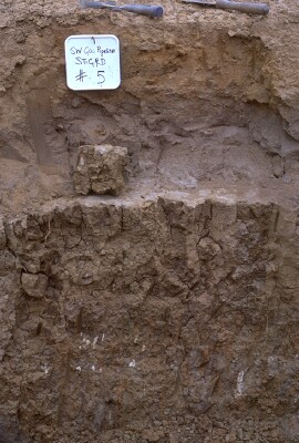 SW100 Profile - Note: Surface stripped from soil profile. |
| A1b | 25-30 cm | Grey; loamy sand; clear change to: NOTE: Buried A horizon. | |
| A2 | 30-55 cm | Greyish brown (10YR5/2 moist) conspicuously bleached (10YR7/1 dry); hardsetting sand; apedal structure; pH 6.4; sharp change to: | |
| Subsoil | |||
| B21t | 55-90 cm | Brown (10YR4/3 moist); medium clay; very coarse (>150 mm) prismatic, parting to coarse polyhedral structure; pH 8.2; gradual change to: | |
| B22t(k) | 90 + cm | Mottled brown and grey; clay loam; few (<5%) small calcium carbonate (CaCO3) accumulations at 1.2 metres depth and concentrated around macropores; pH 9.5. |
Key Profile Features:
- Conspicuously bleached subsurface (A2) horizon.
- Strong texture contrast between surface (A) horizons and subsoil (B21) horizon.
Soil Profile Characteristics:
pH | Salinity Rating | |||
Surface | Striped so not sampled | - | - | - |
Sub-Surface (A2 horizon) | Slightly Acid | Low | Strongly Sodic | - |
Subsoil (B21 horizon) | Moderately Alkaline | Low | Strongly Sodic | Strong-Complete |
Deeper Subsoil (at 100 cm) | Very Strongly Alkaline | Medium-High | Strongly Sodic | - |

| The surface is slightly acid. The subsoil is moderately alkaline becoming very strongly alkaline at depth. | Salinity rating is low in the surface and upper subsoil becoming medium to high in the subsoil. | The soil is strongly sodic in the sub-surface and subsoil. | The clay content increases markedly at the A/B boundary. |
Horizon | Sample Depth (cm) | pH (water) | pH (CaCl2) | EC 1:5 | NaCl % | Exchangeable Cations | |||
Ca | Mg | K | Na | ||||||
meq/100g | |||||||||
Ap | 0-30 | - | - | - | - | - | - | - | |
A2 | 30-55 | 6.4 | 5.6 | 0.11 | 0.45 | 0.88 | 0.05 | 0.57 | |
Bt | 60-80 | 8.2 | 7 | 0.3 | 0.02 | 4.9 | 7.5 | 0.7 | 8.9 |
B22 | 95-110 | 9.5 | 8.5 | 0.52 | 0.05 | 4.7 | 7.3 | 0.6 | 7.7 |
Horizon | Sample Depth (cm) | Exchangeable Acidity meq/100g | Coarse Sand (0.2- 2.0 mm) | Fine Sand (0.02- 0.2 mm) | Silt (0.002- 0.02 mm) | Clay (<0.002 mm) |
Ap | 0-30 | - | - | - | - | - |
A2 | 30-55 | 1.6 | 33 | 50 | 8 | 8 |
Bt | 60-80 | 17 | 27 | 7 | 46 | |
B22 | 95-110 | 19 | 35 | 10 | 33 |
Management Considerations:
Soil (B) Horizons
- The dense and coarsely structured subsoil is strongly sodic and disperses strongly in water. This will result in restricted root and water movement into the subsoil.
Profile Described By: Richard McEwan (February 1999).
© State of Victoria (Agriculture Victoria) 1996 - .

This work, Victorian Resources Online, is licensed under a Creative Commons Attribution 4.0 licence. You are free to re-use the work under that licence, on the condition that you credit the State of Victoria (Agriculture Victoria) as author, indicate if changes were made and comply with the other licence terms.
The licence does not apply to ‘branding’ or some ‘images or photographs’ that may be owned by third parties. We ask you to seek prior approval to use images using the VRO feedback form. Access to higher quality images can also be provided on request.
This page was last updated on .