
SFS3
Location: Mt Pollock.
Australian Soil Classification: Vertic (& Ferric), Mottled-Subnatric, Grey SODOSOL
General Landscape Description: Possible alluvial fan below eruption point to east.
Site Description: Southern Farming Systems (SFS) 'Concept Farm' crop runoff trial site.
Geology: Quaternary - Newer Volcanics.
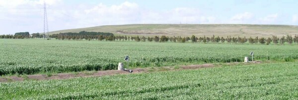 SFS3 Landscape. |
Soil Profile Morphology:
| Surface Soil | 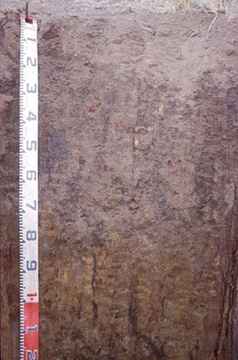 SFS3 Profile. | ||
| Ap | 0-10 cm | Dark brown (10YR3/3) with rusty root channel mottling; fine sandy clay loam; weakly pedal; very firm consistence dry; contains many fine ferruginous nodules; pH 6.2: | |
| Subsoil | |||
| B21cg | 10 – 75 cm | Dark greyish brown (10YR4/2) with brownish yellow (10YR6/6) mottles; fine gravelly clay; fine polyhedral structure; shiny ped faces; abundant fine buckshot; fragments of sub-rounded basalt (up to 100 mm diameter); pH 7.4: | |
| B22 | 75 – 100/110 cm | Brownish yellow (10YR6/6) with dark grey (10YR4/1) infill in earthworm channels; sandy clay; many quartz fragments; very few ferruginous nodules; pH 9.1; wavy change to: | |
| B23ss | 100/110 + cm | Greyish brown (2.5Y5/2); gravelly clay; abundant fine and coarse buckshot; slickensides present (50-100 mm in size); contains weathered basalt fragments; pH 9.0. | |
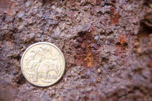 Buckshot and mottling within the B21 horizon. | 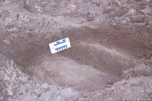 Plough pan at the intersection between the surface and subsoil. |
Key Profile Features:
- Strong texture contrast between surface (A) horizon and subsoil (B21) horizon.
Soil Profile Characteristics:
pH | Salinity Rating | |||
Surface (A1 horizon) | Slightly Acid | Low | Non-Sodic | None |
Subsoil (B21 horizon) | Slightly Alkaline | Low | Sodic | None1 |
Deeper Subsoil (at 1 m) | Very Strongly Alkaline | Low | Strongly Sodic | Strong |
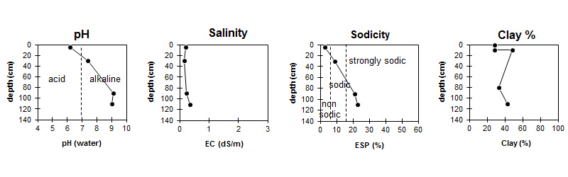
| The pH in the surface is slightly acid. The pH in the subsoil is slightly alkaline becoming very strongly alkaline with depth. | The salinity rating is low throughout. | The surface is non sodic. The subsoil is sodic becoming strongly sodic with depth. | The clay content is moderate throughout the profile. |
Horizon | Horizon Depth (cm) | pH (water) | pH (CaCl2) | EC dS/m | NaCl | Exchangeable Cations | |||
Ca | Mg | K | Na | ||||||
meq/100g | |||||||||
Ap | 0-10 | 6.2 | 5.6 | 0.21 | 9.7 | 4.9 | 0.65 | 0.81 | |
B21g | 10-75 | 7.4 | 6.2 | 0.15 | 6.6 | 12 | 1.2 | 2.8 | |
B22 | 75-100/110 | 9.1 | 7.8 | 0.23 | 4 | 9.4 | 0.47 | 4.3 | |
B23 | 100/110+ | 9 | 7.9 | 0.35 | 0.03 | 5.5 | 13 | 0.7 | 6.5 |
Horizon | Horizon Depth (cm) | Exchangeable Aluminium mg/kg | Exchangeable Acidity meq/100g | Oxidisable Organic Carbon % | Total Nitrogen % | Field Capacity pF2.5 | Wilting Point pF4.2 | Coarse Sand (0.2-2.0 mm) | Fine Sand (0.02-0.2 mm) | Silt (0.002-0.02 mm) | Clay (<0.002 mm) |
Ap | 0-10 | <10 | 9.7 | 2.3 | 0.21 | 31.5 | 14.6 | 16 | 38 | 14 | 29 |
B21g | 10-75 | 7.3 | 40.5 | 20.8 | 22 | 19 | 7 | 49 | |||
B22 | 75-100/110 | 1.5 | 31.7 | 14.5 | 17 | 42 | 8 | 33 | |||
B23 | 100/110+ | 2.4 | 44.9 | 21.3 | 14 | 31 | 12 | 43 |
Management Considerations:
Whole Profile
- Plant available water capacity (PAWC) is considered to be medium (estimated at 107 mm) in the upper 75 cm of this soil profile. Effective rooting depth (ERD) is restricted to 75 cm due to the highly sodic subsoils (ESP>20).
Profile Described By: Richard MacEwan (May 1999).
© State of Victoria (Agriculture Victoria) 1996 - .

This work, Victorian Resources Online, is licensed under a Creative Commons Attribution 4.0 licence. You are free to re-use the work under that licence, on the condition that you credit the State of Victoria (Agriculture Victoria) as author, indicate if changes were made and comply with the other licence terms.
The licence does not apply to ‘branding’ or some ‘images or photographs’ that may be owned by third parties. We ask you to seek prior approval to use images using the VRO feedback form. Access to higher quality images can also be provided on request.
This page was last updated on .