
SFS14
Location: Mt Pollock.
Australian Soil Classification: Ferric (& Calcic), Mottled-Mesonatric, Grey SODOSOL
General Landscape Description: Plain.
Site Description: Southern Farming Systems (SFS) 'Concept Farm' - surface run-off/deep drainage pasture plot.
Geology: Quaternary - Newer Volcanics
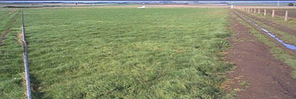 SFS14 Landscape. |
Soil Profile Morphology:
| Surface Soil | |||
| A1 | 0-15 cm | Very dark greyish brown (10YR3/2); fine sandy clay loam; weakly pedal; common amount of ferruginous buckshot; many fine roots; pH 5.2; abrupt and wavy change to: | |
| Subsoil | |||
| B21 | 15-55 cm | Very dark brown (10YR3/2) with yellowish brown (10YR5/6) mottles; gravelly medium clay; very coarse prismatic, parting to medium polyhedral structure; common fine (<2 mm in size) ferruginous buckshot; pH 7.7: | |
| B22k | 55+ cm | Brown (10YR5/3); medium clay; few fine (<2mm in size) ferruginous buckshot as well as soft calcareous segregations; contains basalt cobbles (up to 200 mm in size); pH 9.1. | |
Key Profile Features:
- Strong texture contrast between surface (A1) horizon and subsoil (B21) horizon.
Soil Profile Characteristics:
pH | Salinity Rating | |||
Surface (A1 horizon) | Strongly Acid | Low | Non-Sodic | None |
Subsoil (B21 horizon) | Slightly Alkaline | Low | Strongly Sodic | Strong-Complete |
Deeper Subsoil (at 55+ cm) | Very Strongly Alkaline | Medium | Strongly Sodic | Strong |
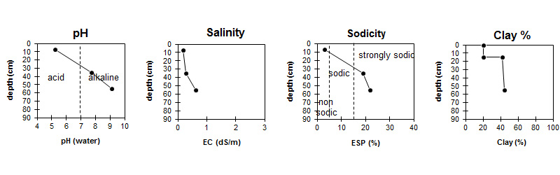
| The pH in the surface is strongly acid. The pH in the subsoil is slightly alkaline becoming very strongly alkaline with depth. | The salinity rating is low in both the surface and upper subsoil. The salinity rating increases to medium in the deeper subsoil. | The surface is non sodic. The subsoil is strongly sodic. | The clay content increases sharply at the surface / subsoil interface. |
Horizon | Horizon Depth (cm) | pH (water) | pH (CaCl2) | EC dS/m | NaCl | Exchangeable Cations | |||
Ca | Mg | K | Na | ||||||
meq/100g | |||||||||
A1 | 0-15 | 5.2 | 4.7 | 0.18 | 4.6 | 4.1 | 0.59 | 0.73 | |
B21 | 15-55 | 7.7 | 6.7 | 0.29 | 0.03 | 5.4 | 9.2 | 0.9 | 3.6 |
B22k | 55+ | 9.1 | 8.4 | 0.61 | 0.06 | 6.6 | 12 | 1 | 5.4 |
Horizon | Horizon Depth (cm) | Exchangeable Aluminium mg/kg | Exchangeable Acidity meq/100g | Oxidisable Organic Carbon % | Total Nitrogen % | Field Capacity pF2.5 | Wilting Point pF4.2 | Coarse Sand (0.2-2.0 mm) | Fine Sand (0.02-0.2 mm) | Silt (0.002-0.02 mm) | Clay (<0.002 mm) |
A1 | 0-15 | <10 | 11 | 3.6 | 0.31 | 28.2 | 12.7 | 10 | 47 | 15 | 21 |
B21 | 15-55 | 36.4 | 19.6 | 14 | 31 | 11 | 42 | ||||
B22k | 55+ | 41.5 | 20.4 | 11 | 25 | 10 | 44 |
Management Considerations:
Whole Profile
- Plant available water capacity (PAWC) is considered to be medium (estimated at 107 mm) in the upper 100 cm of this soil profile.
Profile Described By: Tim Johnston (April 2000).
© State of Victoria (Agriculture Victoria) 1996 - .

This work, Victorian Resources Online, is licensed under a Creative Commons Attribution 4.0 licence. You are free to re-use the work under that licence, on the condition that you credit the State of Victoria (Agriculture Victoria) as author, indicate if changes were made and comply with the other licence terms.
The licence does not apply to ‘branding’ or some ‘images or photographs’ that may be owned by third parties. We ask you to seek prior approval to use images using the VRO feedback form. Access to higher quality images can also be provided on request.
This page was last updated on .