
SFS13
Location: Mt Pollock.
Australian Soil Classification: Vertic, Mottled-Subnatric, Black SODOSOL
General Landscape Description: Possible alluvial fan below eruption point to east.
Site Description: Southern Farming System (SFS) raised bed site. Simple slope, approximately 300m upslope from SFS3.
Geology: Quaternary - Newer Volcanics.
Land Use: Canola in raised beds.
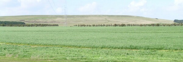
| SFS13 Landscape |
Soil Profile Morphology:
| Surface Soil | 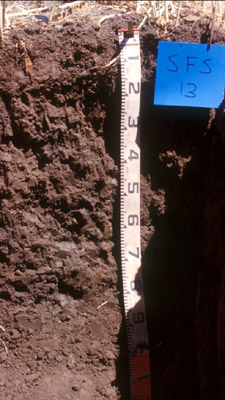 SFS13 Profile | ||
| Ap | 0-20 cm | Very dark greyish brown (10YR3/2); medium clay; granular surface condition; fine structure with a few strong coarse peds; loose friable to very firm consistence dry; very few buckshot; pH 6.1; sharp change to: | |
| Subsoil | |||
| B21g | 20-60 cm | Very dark grey (10YR3/1) with many dark yellowish brown (10YR4/6) mottles; medium heavy clay; coarse prismatic, parting to coarse blocky structure; rigid consistence dry; some fine roots in gleyed portion of peds; pH 6.3: NOTE: 20-40 cm depth an A2 can infrequently occur - very occasional pockets of grey (10YR5/1 dry) gravelly material. | |
| B22 | 60-80+ cm | Very dark grey (5Y3/1); lenticular structure; slickensides evident; pH 8.2. | |
Key Profile Features:
- Strong texture contrast between surface (A) horizon and subsoil (B21) horizon.
- Extremely tough subsoil to excavate with a back hoe.
- Open cracks (>3 mm width) occur within the whole subsoil to 90 cm depth.
Soil Profile Characteristics:
pH | Salinity Rating | |||
Surface (A1 horizon) | Slightly Acid | Low-Medium | Non-Sodic | None1 |
Subsoil (B21 horizon) | Slightly Acid | Very Low | Marginally Sodic | Slight |
Deeper Subsoil (60-80+ cm) | Moderately Alkaline | Low | Strongly Sodic | Slight - Moderate |
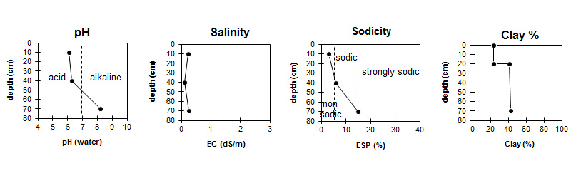
| The salinity rating is low to medium in the surface. The subsoil is very low to low. | The surface is non sodic. The upper subsoil is marginally sodic becoming strongly sodic with depth. | The clay content increases sharply at the surface / subsurface interface. |
Horizon | Horizon Depth (cm) | pH (water) | pH (CaCl2) | EC dS/m | Total Nitrogen % | Exchangeable Cations | |||
Ca | Mg | K | Na | ||||||
meq/100g | |||||||||
Ap | 0-20 | 6.1 | 5.7 | 0.22 | 0.20 | 8.5 | 4.8 | 0.47 | 0.72 |
B21 | 20-60 | 6.3 | 5.3 | 0.12 | 6.7 | 9.9 | 0.81 | 1.6 | |
B22 | 60-80 | 8.2 | 7.3 | 0.25 | 6.7 | 13 | 0.71 | 3.7 | |
Horizon | Horizon Depth (cm) | Oxidisable Organic Carbon % | Exchangeable Aluminium mg/kg | Exchangeable Acidity meq/100g | Field Capacity pF2.5 | Wilting Point pF4.2 | Coarse Sand (0.2-2.0 mm) | Fine Sand (0.02-0.2 mm) | Silt (0.002-0.02 mm) | Clay (<0.002 mm) |
Ap | 0-20 | 2.4 | <10 | 10 | 27.7 | 13.1 | 18 | 37 | 15 | 24 |
B21 | 20-60 | <10 | 9.3 | 34.9 | 19.3 | 13 | 31 | 12 | 42 | |
B22 | 60-80 | 37.8 | 20.2 | 12 | 31 | 11 | 43 |
Management Considerations:
Whole Profile
- Plant available water capacity (PAWC) is considered to be medium (estimated at 103 mm) in the upper 100 cm of this soil profile.
Profile Described By: Richard MacEwan (December 1999).
© State of Victoria (Agriculture Victoria) 1996 - .

This work, Victorian Resources Online, is licensed under a Creative Commons Attribution 4.0 licence. You are free to re-use the work under that licence, on the condition that you credit the State of Victoria (Agriculture Victoria) as author, indicate if changes were made and comply with the other licence terms.
The licence does not apply to ‘branding’ or some ‘images or photographs’ that may be owned by third parties. We ask you to seek prior approval to use images using the VRO feedback form. Access to higher quality images can also be provided on request.
This page was last updated on .