
SFS12
Location: Mt Pollock
Australian Soil Classification: Calcic, Self-Mulching, Brown VERTOSOL
Site Description: Southern Farm Systems (SFS) field day raised bed demonstration site.
Land Use: Canola crop.
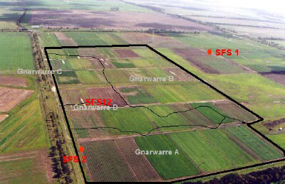
SFS12 Landscape. Also shows the Map Units within the Gnarwarre SFS trial site (Adcock, 1998).
Soil Profile Morphology:
| Surface Soil | 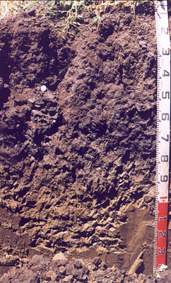 SFS12 Profile | ||
| Ap | 0-20 cm | Very dark greyish brown (10YR3/2); self-mulching surface condition; light medium clay; fine to medium friable structure; very firm to strong consistence dry; pH 5.5; sharp change to: | |
| Subsoil | |||
| B21tg | 20-30/60 cm | Very dark grey (10YR3/1) with prominent common strong brown (7.5YR4/6) mottles as well as distinct common light grey (2.5Y7/2) and yellow (2.5Y7/6) mottles; medium heavy clay; very coarse prismatic, parting to fine prismatic, parting to blocky structure; irregular smooth faced peds; pH 6.7; gradual and irregular change to: | |
| B22ss | 30/60-90 cm | Dark grey (5Y4/1) becoming dark greyish brown (2.5Y4/2); light medium clay; coarse slickensides evident; pH 8.5; gradual change to: NOTE: most moisture is at this depth (base of cracks). | |
| B23g | 90-130 cm | Pale olive (5Y6/4) with fine to coarse olive yellow (2.5Y6/6) mottles; sandy light clay; massive apedal structure; friable consistence moist; very few coarse calcium carbonate concretions; slight effervescence at B22/B23 junction; pH 9.1. | |
Key Profile Features:
- Clay texture throughout soil profile.
- Significant shrinking and swelling occurs during wetting and drying cycles.
- Strong cracking when profile dries.
Soil Profile Characteristics:
pH | Salinity Rating | |||
Surface (A1 horizon) | Strongly Acid | Low-Medium | Non-Sodic | None1 |
Subsoil (B21 horizon) | Slightly Acid | Low-Medium | Sodic | Strong |
Deeper Subsoil (at 1 m) | Very Strongly Alkaline | Medium-High | Strongly Sodic | Strong |
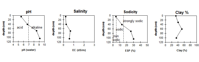
| The salinity rating is low to medium in the surface and upper subsoil, becoming medium to high in the deeper subsoil. | The surface is non sodic. The subsoil is sodic becoming strongly sodic with depth. | The clay content is moderate throughout the profile. |
Horizon | Horizon Depth (cm) | pH (water) | pH (CaCl2) | EC dS/m | NaCl % | Exchangeable Cations | |||
Ca | Mg | K | Na | ||||||
meq/100g | |||||||||
Ap | 0-20 | 5.5 | 4.9 | 0.20 | 7.0 | 5.6 | 0.43 | 0.92 | |
B21 | 20-30/60 | 6.7 | 5.7 | 0.25 | 5.5 | 7.9 | 0.66 | 3.3 | |
B22 | 30/60-90 | 8.5 | 7.9 | 0.67 | 0.09 | 6.7 | 11 | 0.6 | 6.5 |
B23 | 90-130 | 9.1 | 8.3 | 0.56 | 0.08 | 4.9 | 9.6 | 0.3 | 6.4 |
Horizon | Horizon Depth (cm) | Exchangeable Aluminium mg/kg | Exchangeable Acidity meq/100g | Oxidisable Organic Carbon % | Total Nitrogen % | Field Capacity pF2.5 | Wilting Point pF4.2 | Coarse Sand (0.2-2.0 mm) | Fine Sand (0.02-0.2 mm) | Silt (0.002-0.02 mm) | Clay (<0.002 mm) |
Ap | 0-20 | 14 | 12 | 1.6 | 0.15 | 28.2 | 15.2 | 18 | 29 | 16 | 34 |
B21 | 20-30/60 | 8.1 | 35.1 | 18.9 | 14 | 26 | 17 | 40 | |||
B22 | 30/60-90 | <5 | 48.2 | 25.7 | 10 | 19 | 16 | 53 | |||
B23 | 90-130 | 15 | 35 | 15 | 35 |
Management Considerations:
Whole Profile
- Plant available water capacity (PAWC) is considered to be low (estimated at 61 mm) in the upper 50 cm of this soil profile. Effective rooting depth (ERD) is restricted to 50 cm due to the highly sodic subsoils (ESP>20).
Profile Described By: Richard MacEwan (November 1999).
Reference:
Adcock D 1998. Gnarwarre Soil Survey. Centre for Environmental Management, University of Ballarat. unpublished.
© State of Victoria (Agriculture Victoria) 1996 - .

This work, Victorian Resources Online, is licensed under a Creative Commons Attribution 4.0 licence. You are free to re-use the work under that licence, on the condition that you credit the State of Victoria (Agriculture Victoria) as author, indicate if changes were made and comply with the other licence terms.
The licence does not apply to ‘branding’ or some ‘images or photographs’ that may be owned by third parties. We ask you to seek prior approval to use images using the VRO feedback form. Access to higher quality images can also be provided on request.
This page was last updated on .