
CSLP4
Location: Simpson
Australian Soil Classification: Parapanic, Humosesquic, Semiaquic, PODOSOL
General Landscape Description: Dissected Plateau.
Site Description: Side slope.
Geology: Neogene sediments – Hanson Plains Sand.
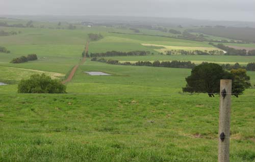
CSLP4 Landscape (foreground only).
Soil Profile Morphology:
Surface Soil
| A1 | 0-12 cm | Black (2.5Y2.5/1); light coarse sandy loam; massive; sandy fabric; very weak consistence dry; many roots present; pH 5.0; clear and wavy change to: NOTE: Peat layer of 1-2 cm at 10 cm depth. | No pit photo available. |
| A2 | 12-20 cm | Grey (Gley2 5/5B) (Gley1 N 6/ dry); coarse sandy loam; fine single grain structure; sandy fabric; very weak consistence dry; common amount of roots present; pH 4.7; change to: | |
| 2A1 | 20-42 cm | Dark grey (Gley1 N 4/) sporadically bleached; sand; fine single grain structure; sandy fabric; weak consistence dry; a common amount of roots present; pH 4.3; change to: | |
| 2A2 | 42-50 cm | Dark brown (7.5YR3/1); loamy coarse sand; massive; sandy fabric; firm consistence moderately moist; very few roots present; humus accumulation; pH 4.3; change to: | |
| Subsoil | |||
| 2Bhs | 50-57 cm | Very dark brown (7.5YR2.5/1) with many distinct, dark brown (7.5YR3/3) mottles; loamy coarse sand; massive; sandy fabric; very strong consistence moderately moist; very strongly cemented continuous pan evident; pH 4.4; change to: | |
| 2BC | 57-110 cm | Yellow (10YR7/5) with many prominent yellowish brown (10YR5/6) and dark yellowish brown (10YR3/4) mottles; loamy coarse sand; massive; sandy fabric; very strong consistence dry; very strongly cemented sandy continuous pan evident; pH 4.4. | |
Soil Profile Characteristics:
pH | Salinity Rating | |||
Surface (A1 horizon) | Strongly Acid | Low | Non-Sodic | None |
Subsoil (B2hs horizon) | Extremely Acid | Low-Medium | Non-Sodic | None |
Deeper Subsoil (at 57-110 cm) | Extremely Acid | Low-Medium | Non-Sodic | None |
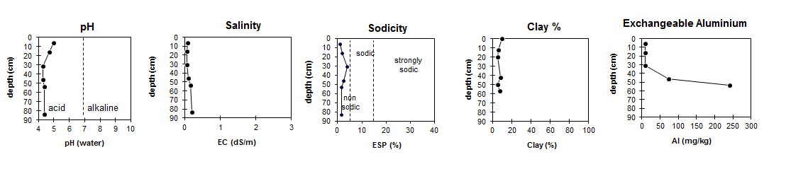
| The surface horizon is strongly acid. The subsoil is extremely acid. | The salinity rating in the surface soil is low. The subsoil has a low to medium salinity rating. | This profile is non-sodic. |
| The exchangeable aluminium levels in the surface are low. From 50cm depth the levels increase and become very high. |
Horizon | Horizon Depth (cm) | pH (water) | pH CaCl2 | EC (dS/m) | Exchangeable Cations | |||
Ca | Mg | K | Na | |||||
meq/100g | ||||||||
A1 | 0-12 | 5 | 4.4 | 0.09 | 7.30 | 0.56 | 0.15 | 0.26 |
A2 | 12-20 | 4.7 | 3.9 | 0.06 | 2.60 | 0.31 | 0.11 | 0.21 |
2A1 | 12-42 | 4.3 | 3.8 | 0.06 | 0.45 | 0.08 | 0.06 | 0.14 |
2A2 | 42-50 | 4.3 | 3.8 | 0.1 | 0.54 | 0.15 | 0.12 | 0.26 |
2Bhs | 50-57 | 4.4 | 4.2 | 0.17 | 0.41 | 0.21 | 0.17 | 0.34 |
2BC | 57-110 | 4.4 | 4.6 | 0.21 | 0.05 | 0.14 | 0.25 | 0.38 |
Horizon | Horizon Depth (cm) | Exchangeable Acidity meq/100g | Organic Carbon g/100g | Field Capacity pF2.5 | Wilting Point pF4.2 | Exchangeable Aluminium mg/kg | Coarse Sand (0.2-2.0 mm) | Fine Sand (0.02-0.2 mm) | Silt (0.002-0.02 mm) | Clay (<0.002 mm) |
A1 | 0-12 | 14 | 6.6 | 37.3 | 16.9 | <10 | 38 | 43 | 8 | 10 |
A2 | 12-20 | 7.5 | 2.6 | 14.6 | 4.5 | <10 | 38 | 46 | 2 | 6 |
2A1 | 12-42 | 2.7 | 0.51 | 10.6 | 1.1 | <10 | 36 | 52 | 3 | 6 |
2A2 | 42-50 | 9 | 1.6 | 12 | 2.4 | 74 | 34 | 49 | 8 | 8 |
2Bhs | 50-57 | 19 | 2.7 | 18 | 6.7 | 240 | 30 | 44 | 12 | 6 |
2BC | 57-110 | 21 | 1.3 | 34.7 | 11.8 | 130 | 28 | 41 | 14 | 8 |
Profile Described By: David Rees, Michelle Davey, Nathan Robinson (November 2008).
© State of Victoria (Agriculture Victoria) 1996 - .

This work, Victorian Resources Online, is licensed under a Creative Commons Attribution 4.0 licence. You are free to re-use the work under that licence, on the condition that you credit the State of Victoria (Agriculture Victoria) as author, indicate if changes were made and comply with the other licence terms.
The licence does not apply to ‘branding’ or some ‘images or photographs’ that may be owned by third parties. We ask you to seek prior approval to use images using the VRO feedback form. Access to higher quality images can also be provided on request.
This page was last updated on .