
SW80
Location: Yeo
Australian Soil Classification: Vertic, Mottled--Mesonatric, Grey SODOSOL
Great Soil Group: solodized solonetz
General Landscape Description: Undulating rises
Site Description: Open depression
Geology: Mapped as Tertiary-Gellibrand Marl but has alluvial material overlying it
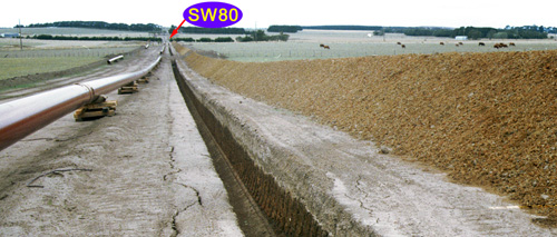 SW80 Landscape |
Soil Profile Morphology:
Surface Soil
| A1 | 0-15 cm | Very dark greyish brown (10YR3/2 moist), greyish brown (10YR5/2 dry) loam, fine sandy; weakly pedal; weak consistence dry. | 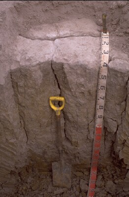 SW80 Profile. Note: Surface (A1) horizon has been stripped from the soil profile. |
| A2e | 15-40 cm | Brown (10YR5/3 moist), conspicuously bleached (10YR7/2 dry); loamy sand; pH 5.4; sharp domed change to: | |
| Subsoil | |||
| B21t | 40-90 cm | Very dark grey (10YR3/1 moist) with fine yellowish brown (10YR5/8) mottles ; heavy clay; coarse (up to 400 mm) columnar structure, parting with difficulty to coarse blocky structure; slickensides across ped; pH 7.5 gradual change to: | |
| B22gss | 90-140 cm | Very dark grey (10YR3/1 moist) with ~ 50% coarse olive brown (2.5Y4/4 moist) mottles; heavy clay; coarse columnar peds continuous from B21; slickensides more prominent than in B21 above; pH 7.5; clear change to: | |
| B23g | 140+ cm | Conspicuously mottled, gleyed clay; massive; pH 7.5. |
Key Profile Features:
- Strong texture contrast between surface (A) horizons and subsoil (B) horizons.
- Coarse columnar structure in upper subsoil.
Soil Profile Characteristics:
pH | Salinity Rating | |||
Surface (A2 horizon) | Strongly Acid | Very Low | Non-Sodic | None |
Subsoil (B21 horizon) | Slightly Alkaline | Low | Strongly Sodic | Strong |
Deeper Subsoil (at 100-120 cm) | Slightly Alkaline | Low - Medium | Strongly Sodic | Strong - Complete |
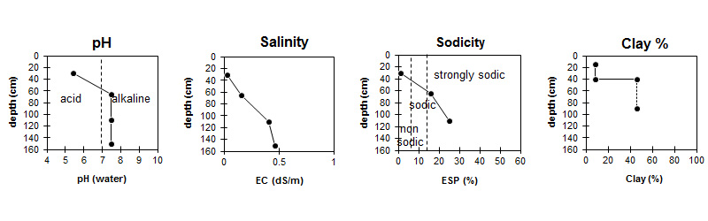
| The surface soil is strongly acid. The subsoil is slightly alkaline. | Salinity rating is very low in the surface becoming low in the subsoil, increasing to moderate levels in the deeper subsoil. |
| The clay content increases markedly at the A/B boundary. |
Horizon | Sample Depth (cm) | pH (water) | pH (CaCl2) | EC 1:5 | NaCl % | Exchangeable Cations | |||
Ca | Mg | K | Na | ||||||
meq/100g | |||||||||
A1 | 0-15 | - | - | - | - | - | - | - | - |
A2 | 20-40 | 5.4 | 4.5 | <0.05 | 1.2 | 0.29 | 0.19 | 0.07 | |
B21t | 50-70 | 7.5 | 6.4 | 0.16 | 4.5 | 10 | 0.23 | 2.7 | |
B22gss | 100-120 | 7.5 | 6.6 | 0.41 | 0.06 | 3.7 | 8.4 | 0.2 | 4.1 |
B23g | 140+ | 7.5 | 6.6 | 0.46 | 0.09 | ||||
Horizon | Sample Depth (cm) | Exchangeable Aluminium mg/kg | Exchangeable Acidity meq/100g | Coarse Sand (0.2- 2.0 mm) | Fine Sand (0.02- 0.2 mm) | Silt (0.002- 0.02 mm) | Clay (<0.002 mm) |
A1 | 0-15 | - | - | - | - | - | - |
A2 | 20-40 | 17 | 5.6 | 4 | 62 | 23 | 8 |
B21t | 50-70 | 2 | 36 | 14 | 46 | ||
B22gss | 100-120 | ||||||
B23g | 140+ |
Management Considerations:
Subsoil (B) Horizons
- The subsoil displays vertic features (i.e. slickensides) which indicates that significant shrinking and swelling occurs during wetting and drying cycles. This may have engineering implications and is likely to explain the variability in surface horizon depth across the trench.
- The dense and coarsely structured subsoil is strongly sodic and disperse strongly in water. This will result in restricted root and water movement down the soil profile.
Profile Described By: Richard McEwan (March 1999).
© State of Victoria (Agriculture Victoria) 1996 - .

This work, Victorian Resources Online, is licensed under a Creative Commons Attribution 4.0 licence. You are free to re-use the work under that licence, on the condition that you credit the State of Victoria (Agriculture Victoria) as author, indicate if changes were made and comply with the other licence terms.
The licence does not apply to ‘branding’ or some ‘images or photographs’ that may be owned by third parties. We ask you to seek prior approval to use images using the VRO feedback form. Access to higher quality images can also be provided on request.
This page was last updated on .