
SW79
Location: Yeo
Australian Soil Classification: Vertic, Mottled-Subnatric, Black SODOSOL
Great Soil Group: Solodic
General Landscape Description: Gently undulating rises.
Site Description: Crest of lower slope (2o).
Geology: Mapped as Tertiary-Gellibrand Marl (Colac sheet 1:50 000) but most likely Hanson Plain Sand
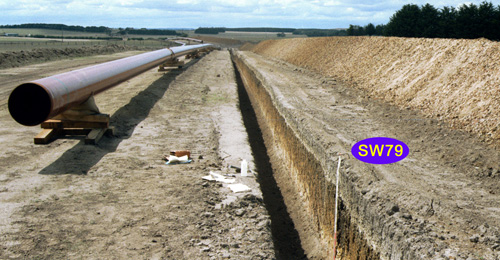 SW79 Landscape |
Soil Profile Morphology:
Surface Soil
| Ap | 0-20 cm | Very dark brown (10YR2/2 moist), gray (10YR5/1 dry); fine sandy loam; pH 5.1; clear change to: | 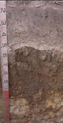 SW79 Profile. Note: Surface (Ap) horizon has been stripped from the soil profile |
| A21e | 20-40 cm | grayish brown (10YR5/2 moist), conspicuously bleached (10YR7/1 dry); fine sandy loam; pH 6.4; clear change to: | |
| A22ec | 40-50 cm | grayish brown (10YR5/2 moist), very pale brown (10YR8/2 dry); fine sandy loam; abundant rounded ironstone gravel (5-20 mm), minor fine quartz (8-20 mm); sharp change to: | |
| Subsoil | |||
| B2t | 50-90/110 cm | Very dark grayish brown (10YR3/2 moist) with few, fine (up to 20 mm) red mottles on ped interiors; medium heavy clay; strongly pedal, coarse to medium (40-60 mm) prismatic, parting to coarse (30-40 mm) blocky structure (with some fine lenticular peds); sandier matrix as horizon deepens; pH 6.6; abrupt to clear and irregular change to: | |
| C | 110 cm+ | Yellow and gray mottled cemented sand with thick dark clay infills in cracks; infills can be quite thick (3 mm) and take form of vertical lenticular clay peds; pH 6. |
Key Profile Features:
- Strong texture contrast between surface (A) horizons and subsoil (B21) horizons.
- Large amount of iron stone gravel ("buckshot") in deeper subsurface (A22) horizon.
Soil Profile Characteristics:
pH | Salinity Rating | |||
Surface (Ap horizon) | Strongly Acid | Medium | Non-Sodic | None |
Subsoil (B21 horizon) | Slightly Acid | Very Low | Marginally Sodic | None |
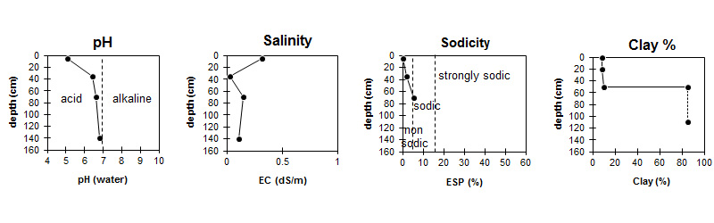
| The surface soil is strongly acid. The subsoil is slightly acid. | Salinity rating is medium in the surface becoming very low in the subsoil. |
| The clay content increases markedly at the A/B boundary. |
Horizon | Horizon Depth (cm) | pH (water) | pH (CaCl2) | EC 1:5 | NaCl % | Exchangeable Cations | |||
Ca | Mg | K | Na | ||||||
meq/100g | |||||||||
Ap | 0-10 | 5.1 | 4.5 | 0.32 | 0.03 | 3.5 | 0.8 | 0.7 | <0.1 |
A2 | 25-40 | 6.4 | 5.4 | <0.05 | 0.99 | 0.97 | 0.07 | 0.17 | |
B2 | 60-80 | 6.6 | 6.1 | 0.15 | 4.4 | 8.5 | 0.19 | 1.5 | |
C | 130+ | 6.8 | 6 | 0.11 | 0.02 | ||||
Horizon | Horizon Depth (cm) | Exchangeable Aluminium mg/kg | Exchangeable Acidity meq/100g | Organic Carbon % | Nitrogen % | Field Capacity pF2.5 | Wilting Point pF4.2 | Coarse Sand (0.2- 2.0 mm) | Fine Sand (0.02- 0.2 mm) | Silt (0.002- 0.02 mm) | Clay (<0.002 mm) |
Ap | 0-10 | 24 | 16 | 4.9 | 0.42 | 26.2 | 10.9 | 21 | 45 | 15 | 8 |
A2 | 25-40 | <10 | 4.4 | 15 | 3.5 | 19 | 54 | 17 | 10 | ||
B2 | 60-80 | 12 | 42.3 | 30.1 | 3 | 8 | 4 | 85 | |||
C | 130+ |
Management Considerations:
Subsoil (B) Horizons
- The subsoil displays vertic features (i.e. slickensides) which indicates that significant shrinking and swelling occurs during wetting and drying cycles. This may have engineering implications and is likely to explain the variability in surface horizon depth across the trench.
- As the B horizon approaches C horizon peds gradually become sandier in the matrix until subsoil takes on the appearance of a fractured sandstone with thick clay coatings infilling in the cracks. These in places are quite thick (~3 mm) and take on form of vertical lenticular peds.
- Soil approx. 1 m over weathered sandstone probably Tpb but mapped as Tmi on 1:50 000 Beech Forest geology sheet. Boundary to B horizon becomes extremely wavy (30-80 cm depth) as unit continues down slope. Abundant gravel in A2, 100 to 400 mm thickness.
Profile Described By: Richard McEwan (March 1999).
© State of Victoria (Agriculture Victoria) 1996 - .

This work, Victorian Resources Online, is licensed under a Creative Commons Attribution 4.0 licence. You are free to re-use the work under that licence, on the condition that you credit the State of Victoria (Agriculture Victoria) as author, indicate if changes were made and comply with the other licence terms.
The licence does not apply to ‘branding’ or some ‘images or photographs’ that may be owned by third parties. We ask you to seek prior approval to use images using the VRO feedback form. Access to higher quality images can also be provided on request.
This page was last updated on .