
SW76
Location: Tulloh
Australian Soil Classification: Vertic, Mottled-Subnatric, Brown SODOSOL
General Landscape Description: Undulating low hills.
Site Description: Waxing upper slope, 10%, eastern aspect.
Geology: Tertiary sediments (either Dilwyn or Eastern View Formation.
Soil Profile Morphology:
Surface Soil
| A1 | 0-15 cm | Very dark gray (10YR3/1 moist), gray (10YR 5/1 dry); sandy loam; weakly pedal; pH 5.5: | 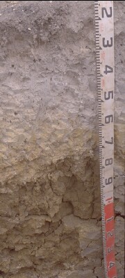 SW76 Profile. Note: Surface (A1) horizon has been stripped from the soil profile. |
| A21ec | 15-50 cm | grayish brown (10YR5/2 moist), conspicuously bleached (10YR7/1 dry); sandy loam; apedal, massive; minor small buckshot (breaking with moderate force); pH 5.6; abrupt change to: | |
| A22 | 50-70/80 cm | Yellowish brown (10YR5/6 moist), brownish yellow (10YR6.5/6 dry); apedal; sporadic bleach; pH 5.9; clear change to: | |
| Subsoil | |||
| B21tss | 70/80-135 cm | Mottled strong brown (7.5YR5/8 moist), yellowish brown (10YR5/4 moist), brown cutans (10YR5/3 moist); heavy clay; vertic; very coarse blocky structure [80-100 mm]; some very large slickensides, up to 1 m across; pH 6.0; gradual change to: | |
| B22tg | 135 cm+ | Dark gray (10YR4/1 moist) and white (10YR8/1 moist); heavy clay; red mottles (10R4/8 moist); polyhedral structure; slickensides (50-150 mm); pH 5.4. |
Key Profile Features:
- Deep, conspicuously bleached subsurface (A2) horizons.
- Strong texture contrast between surface (A) horizons and subsoil (B2) horizon.
- Vertic features (i.e. slickensides) in subsoil.
Soil Profile Characteristics:
pH | Salinity Rating | |||
Surface (A1 horizon) | Strongly Acid | Low | Non-Sodic | None |
Subsoil (B21 horizon) | Moderately Acid | Very Low | Marginally Sodic | * |
Deeper Subsoil (at 110+ cm) | Strongly Acid | Very Low | - | * |
| * No results | ||||
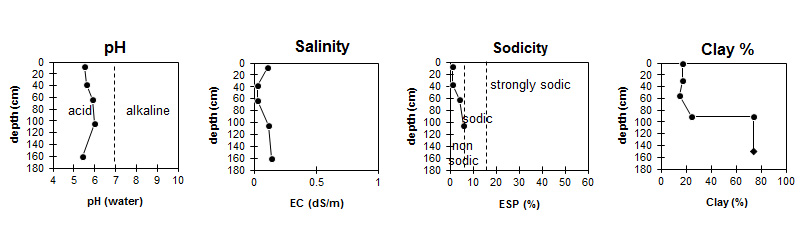
| The surface soil is strongly acid. The subsoil is moderately acid becoming strongly acid with depth. | Salinity rating is low in the surface becoming very low in the subsoil. |
| The clay content increases markedly at the A/B boundary. |
Horizon | Sample Depth (cm) | pH (water) | pH (CaCl2) | EC 1:5 | NaCl % | Exchangeable Cations | |||
Ca | Mg | K | Na | ||||||
meq/100g | |||||||||
A1 | 0-15 | 5.5 | 4.8 | 0.11 | 2.9 | 1.2 | 0.41 | 0.2 | |
A21ec | 30-45 | 5.6 | 4.7 | <0.05 | 1.2 | 0.87 | <0.05 | 0.1 | |
A22 | 55-70 | 5.9 | 4.9 | <0.05 | 0.7 | 2.1 | <0.05 | 0.32 | |
B21tss | 90-120 | 6 | 5 | 0.12 | 2.3 | 9 | 0.1 | 1.4 | |
B21tg | 150-170 | 5.4 | 4.5 | 0.14 | 0.02 | ||||
Horizon | Sample Depth (cm) | Exchangeable Aluminium mg/kg | Organic Carbon % | Nitrogen % | Exchangeable Acidity meq/100g | Field Capacity pF2.5 | Wilting Point pF4.2 | Coarse Sand (0.2- 2.0 mm) | Fine Sand (0.02- 0.2 mm) | Silt (0.002- 0.02 mm) | Clay (<0.002 mm) |
A1 | 0-15 | 49 | 5.3 | 0.39 | 17 | 30.1 | 11.1 | 14 | 38 | 19 | 17 |
A21ec | 30-45 | 32 | 8.6 | 19.7 | 5.9 | 16 | 44 | 21 | 15 | ||
A22 | 55-70 | <10 | 4 | 19.8 | 8.1 | 16 | 41 | 17 | 25 | ||
B21tss | 90-120 | 28 | 10 | 5 | 10 | 6 | 74 | ||||
B21tg | 150-170 |
Management Considerations:
Subsoil (B) Horizons
- The subsoil displays vertic features (i.e. slickensides) which indicates that significant shrinking and swelling occurs during wetting and drying cycles. This may have engineering implications and is likely to explain the variability in surface horizon depth across the trench.
Notes
- Gleying in subsoil increases down slope from profile.
Profile Described By: Richard McEwan (April 1999).
© State of Victoria (Agriculture Victoria) 1996 - .

This work, Victorian Resources Online, is licensed under a Creative Commons Attribution 4.0 licence. You are free to re-use the work under that licence, on the condition that you credit the State of Victoria (Agriculture Victoria) as author, indicate if changes were made and comply with the other licence terms.
The licence does not apply to ‘branding’ or some ‘images or photographs’ that may be owned by third parties. We ask you to seek prior approval to use images using the VRO feedback form. Access to higher quality images can also be provided on request.
This page was last updated on .