
SW74
Location: Tulloh
Australian Soil Classification: Bleached-Vertic, Eutrophic, Brown CHROMOSOL
General Landscape Description: Undulating low hills.
Site Description: Waxing upper slope, western aspect.
Geology: Thin Tertiary (Dilwyn or Eastern View Formation) over Cretaceous (Otway Group) unconformity.
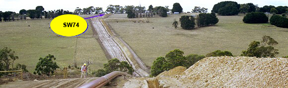 SW74 Landscape |
Soil Profile Morphology:
Surface Soil
| A1 | 0-15 cm | Very dark grayish brown (10YR3/2 moist), dark gray (10YR4/1 dry); loamy sand; apedal; hardsetting; pH 5.4; clear change to: | 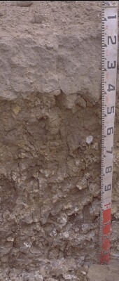 SW74 Profile. Note: Surface (A1) horizon has been stripped from the soil profile. |
| A2 | 15-40 cm | Olive brown (2.5Y4/3 moist) with faint mottling, conspicuously bleached (2.5Y6/3 dry); sandy loam; apedal, massive; contains few medium ferruginous nodules; pH 5.6; sharp and wavy change to: | |
| Subsoil | |||
| B21t | 40-70/80 cm | Sandy yellowish brown (10YR5/6) coarse angular blocky peds with dark grayish brown (10YR4/2) thick heavy clay coatings; some peds dominantly clay; vertic features; pH 6.0; gradual and wavy change to: | |
| B22tg | 70/80-140+ cm | White (gray N8/0) clay with gray (10YR5/1) coatings; red mottles in white clay; strongly vertic; pH 5.5. This horizon is probably a palaeosol developed on Otway Group sediments. |
Key Profile Features:
- Conspicuously bleached subsurface (A2) horizon
- Strong texture contrast between surface (A) horizons and subsoil (B21) horizon.
Soil Profile Characteristics:
pH | Salinity Rating | |||
Surface (A1 horizon) | Strongly Acid | Low | Non-Sodic | None |
Subsoil (B21 horizon) | Moderately Acid | Very Low | Non-Sodic | None |
Deeper Subsoil (at 100+ cm) | Strongly Acid | Very Low | Non-Sodic | None |
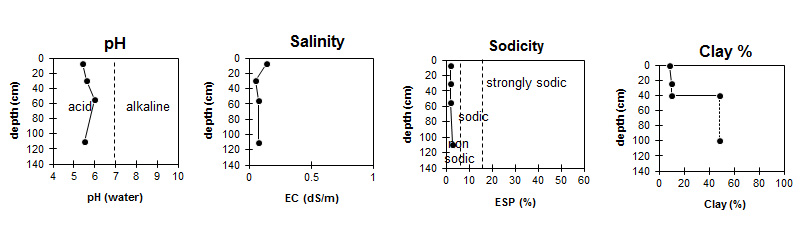
| The surface soil is strongly acid. The subsoil is moderately acid becoming strongly acidic with depth. | Salinity rating is low in the surface becoming very low in the subsoil. |
| The clay content increases markedly at the A/B boundary. |
Horizon | Sample Depth (cm) | pH (water) | pH (CaCl2) | EC 1:5 | Organic Carbon % | Nitrogen % | Exchangeable Cations | |||
Ca | Mg | K | Na | |||||||
meq/100g | ||||||||||
A1 | 0-15 | 5.4 | 4.7 | 0.14 | 7.6 | 0.65 | 2.6 | 0.97 | 0.37 | 0.27 |
A2 | 25-35 | 5.6 | 4.8 | 0.05 | 0.74 | 0.91 | 0.05 | 0.14 | ||
B21t | 45-65 | 6 | 5.3 | 0.08 | 1.9 | 5.2 | 0.08 | 0.49 | ||
B22tg | 100-120 | 5.5 | 4.4 | 0.08 | 1.4 | 8.2 | 0.11 | 0.8 | ||
Horizon | Sample Depth (cm) | Exchangeable Aluminium mg/kg | Exchangeable Acidity meq/100g | Field Capacity pF2.5 | Wilting Point pF4.2 | Coarse Sand (0.2- 2.0 mm) | Fine Sand (0.02- 0.2 mm) | Silt (0.002- 0.02 mm) | Clay (<0.002 mm) |
A1 | 0-15 | 21 | 13 | 22.2 | 9.5 | 39 | 35 | 11 | 9 |
A2 | 25-35 | 15 | 5.3 | 13.7 | 4.2 | 46 | 28 | 13 | 10 |
B21t | 45-65 | <10 | 7.3 | 28.4 | 18.6 | 37 | 8 | 4 | 48 |
B22tg | 100-120 | 13 |
Management Considerations:
Notes
- Possible unconformity of Palaeocene over Cretaceous.
- Strongly vertic with trench collapse.
- This site stood out from adjacent sections of the trench, because of white subsoil material in trench spoil.
Profile Described By: Richard McEwan (April 1999).
© State of Victoria (Agriculture Victoria) 1996 - .

This work, Victorian Resources Online, is licensed under a Creative Commons Attribution 4.0 licence. You are free to re-use the work under that licence, on the condition that you credit the State of Victoria (Agriculture Victoria) as author, indicate if changes were made and comply with the other licence terms.
The licence does not apply to ‘branding’ or some ‘images or photographs’ that may be owned by third parties. We ask you to seek prior approval to use images using the VRO feedback form. Access to higher quality images can also be provided on request.
This page was last updated on .