
SW70
Location: Tulloh
Australian Soil Classification: Humose, Sesquic, Semiaquic PODOSOL
General Landscape Description: Undulating low hills
Site Description: Waxing upper slope
Geology: Ambiguous: Hanson Plain Sand, Dilwyn Formation (Colac 1:250 000), or Eastern View Formation (Colac 1:50 000)
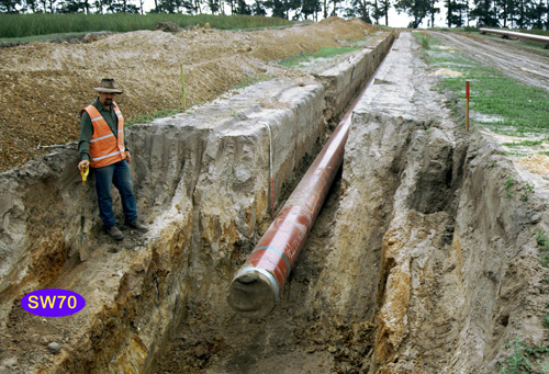 SW70 Landscape |
Soil Profile Morphology:
Surface Soil
| Ap | 0-20/30 cm | Very dark grayish brown (10YR3/2 moist), grayish brown (10YR5/2 dry); loamy sand; apedal; pH 5.3; diffuse change to: | 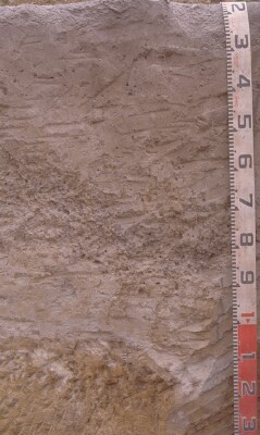 SW70 Profile. Note: Surface (A1) horizon has been stripped from the soil profile |
| A2 | 20/30-90/110 cm | Grayish brown (10YR5/2 moist), conspicuously bleached (10YR7/2 dry); sand; sporadic gravel band (>100 mm); with very many medium to coarse (5-15 mm) nodules with dark manganiferous centres; very weak to weak consistence; pH 5.4; abrupt change to: | |
| Subsoil | |||
| B21s | 90/110-150 cm | Brown (7.5YR4/4 moist and dry) and brownish yellow (10YR6/8 moist) to yellow (10YR7/8 dry); sandy clay loam; cemented sand "coffee rock"; massive; firm to strong consistence; clear change to: | |
| B22g | 150-200 cm | Yellowish brown (10YR5/8 moist) (50%) and light greenish gray (5GY7/1 moist) (50%); very dark grayish brown (10YR3/2 moist) coatings; sandy light clay; pH 6; clear change to: | |
| B23 | 200+ cm | Mottled yellowish brown (10YR5/8 moist) (30%) and light greenish gray (5GY7/1 moist) (70%); apedal. |
Key Profile Features:
- Very thick conspicuously bleached subsurface (A2) horizon.
Soil Profile Characteristics:
pH | Salinity Rating | |||
Surface (Ap horizon) | Strongly Acid | Moderate | Non-Sodic | None |
Subsoil (A2 horizon) | Strongly Acid | Very Low | Non-Sodic | None |
Deeper Subsoil (100+ cm) | Moderately Acid | Very Low | Non-Sodic | None |
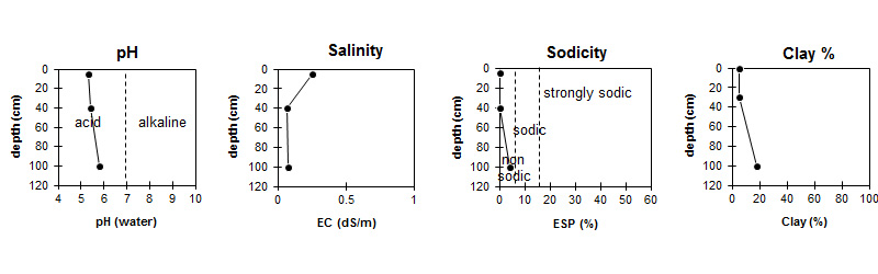
| The surface and upper subsoil is strongly acid. The deeper subsoil is moderately acid. | Salinity rating is moderate in the surface becoming very low in the subsoil. |
| The clay content is quite low throughout the profile. |
Horizon | Sample Depth (cm) | pH (water) | pH (CaCl2) | EC 1:5 | Nitrogen % | Organic Carbon % | Exchangeable Cations | |||
Ca | Mg | K | Na | |||||||
meq/100g | ||||||||||
Ap | 0-10 | 5.3 | 4.6 | 0.25 | 0.31 | 3.2 | 2 | 1.1 | 0.44 | 0.72 |
A2 | 30-50 | 5.4 | 4.6 | 0.07 | 0.27 | 0.13 | <0.05 | 0.18 | ||
B21s | 100+ | 5.8 | 4.9 | 0.08 | 1.3 | 1.9 | 0.09 | 0.33 | ||
Horizon | Sample Depth (cm) | Exchangeable Aluminium mg/kg | Exchangeable Acidity meq/100g | Field Capacity pF2.5 | Wilting Point pF4.2 | Coarse Sand (0.2- 2.0 mm) | Fine Sand (0.02- 0.2 mm) | Silt (0.002- 0.02 mm) | Clay (<0.002 mm) |
Ap | 0-10 | 15 | 9.9 | 15.1 | 6.8 | 50 | 32 | 9 | 5 |
A2 | 30-50 | 11 | 2.1 | 8.2 | 1.2 | 48 | 38 | 8 | 5 |
B21s | 100+ | <10 | 4.1 | 12 | 6 | 46 | 32 | 4 | 18 |
Management Considerations:
Notes
- The area is mapped as Tad and Klp but there are great similarities between Tpb and some of the soil profiles. This question needs to be resolved, particularly the Fe sandstone/Fe gravel/Fe colluvial content. Area between creeks is mapped as Klp but soil is same as that East of Christies-Colac Road. General trend is for gravel to disappear from the A2 on these slopes here and for the subsoil structure to become larger, A2/B more variable, more gleyed and strong vertic features.
Profile Described By: Richard McEwan (April 1999).
© State of Victoria (Agriculture Victoria) 1996 - .

This work, Victorian Resources Online, is licensed under a Creative Commons Attribution 4.0 licence. You are free to re-use the work under that licence, on the condition that you credit the State of Victoria (Agriculture Victoria) as author, indicate if changes were made and comply with the other licence terms.
The licence does not apply to ‘branding’ or some ‘images or photographs’ that may be owned by third parties. We ask you to seek prior approval to use images using the VRO feedback form. Access to higher quality images can also be provided on request.
This page was last updated on .