
SW68
Location: Narangrook West
Australian Soil Classification: Bleached-Mottled, Eutrophic, Brown CHROMOSOL (very thick loamy surface horizons)
General Landscape Description: Gently inclined undulating rises.
Site Description: Crest.
Geology: Hanson Plain Sand
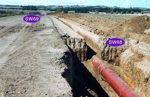 SW68 Landscape |
Soil Profile Morphology:
Surface Soil
| A1 | 0-10 cm | Dark grayish brown (10YR4/2 moist), light brownish gray (10YR6/2 dry); sandy loam; apedal; very weak consistence; pH 5.2: | 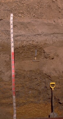 SW68 Profile. Note: Surface (A1) horizon has been stripped from the soil profile. |
| A21eg | 10-60 cm | Very pale brown (10YR7/4 moist), light gray (10YR7/2 dry); sandy loam; abrupt smooth change to: | |
| A22ce | 60-80 cm | Very many (80%) irregular rounded coarse (10-30 mm) ferromanganiferous nodules in a very pale brown (10YR7/4 moist), light gray (10YR7/2 dry) sandy loam matrix: | |
| A3 | 80-90 cm | Yellow/gray mottled; coarse sandy loam with fine distinct red mottles, clear change to: | |
| Subsoil | |||
| B21tg | 90-150 cm | Mottled brown (7.5YR4/4 moist) (50%) and strong brown (7.5YR5/8 moist) (50%); tough heavy clay; firm (moist) consistence; pH 6.2: | |
| B22tg | 150-220/230 cm | Brown (7.5YR4/6 moist) and strong brown (7.5YR5/6 moist) and dark brown (7.5YR3/2 moist) and gray (7.5YR5/1) coatings on ped faces; heavy clay; firm (moist) consistence; pH 6.0; abrupt change to: | |
| C | 220/230 cm+ | Hanson Plain Sand; red and yellow mottled weekly cemented coarse sand, diggable with spade; very many (80%) irregular rounded coarse (10-30 mm) ferromanganiferous nodules in a very pale brown (10YR7/4 moist), light gray (10YR7/2 dry) sandy loam matrix. |
Key Profile Features:
- Very thick conspicuously bleached subsurface (A2) horizon.
- Strong texture contrast between surface (A) horizons and subsoil (B21) horizon.
Soil Profile Characteristics:
pH | Salinity Rating | |||
Surface (A1 horizon) | Strongly Acid | Very Low | Non-Sodic | None |
Subsoil (B21 horizon) | Slightly Acid | Very Low | Non-Sodic | None |
Deeper subsoil (at 150 - 220 cm) | Moderately Acid | Very Low | Non-Sodic | None |
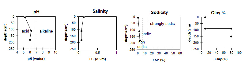
| The surface is strongly acid. The subsoil is slightly acid becoming moderately acid with depth | Salinity rating is very low throughout the profile. | The soil is non sodic throughout. | Clay levels jump markedly at the surface / subsoil boundary. |
Horizon | Sampling Depth (cm) | pH (water) | pH (CaCl2) | EC 1:5 | Organic Carbon % | Nitrogen % | Exchangeable Cations | |||
Ca | Mg | K | Na | |||||||
meq/100g | ||||||||||
A1 | 0-10 | 5.2 | 4.5 | 0.13 | 3.6 | 0.23 | 3.2 | 0.57 | 0.31 | 0.22 |
B21g | 100-120 | 6.2 | 5.7 | 0.08 | 3.3 | 9.7 | 0.15 | 0.43 | ||
B22g | 170-190 | 6 | 5.6 | 0.08 | 1.9 | 11 | 0.14 | 0.62 | ||
Horizon | Sampling Depth (cm) | Exchangeable Aluminium mg/kg | Exchangeable Acidity meq/100g | Field Capacity pF2.5 | Wilting Point pF4.2 | Coarse Sand (0.2- 2.0 mm) | Fine Sand (0.02- 0.2 mm) | Silt (0.002- 0.02 mm) | Clay (<0.002 mm) |
A1 | 0-10 | 48 | 13 | 19.6 | 6.6 | 20.9 | 49.7 | 11.5 | 9.5 |
B21g | 100-120 | <10 | 10 | 43 | 30.3 | 6.1 | 10 | 2.5 | 79 |
B22g | 170-190 | <10 | 10 | 44.9 | 31.6 | 4.3 | 11.4 | 3.5 | 78.5 |
Notes:
- Flat on top of hill, which rises again to the West. Soils becoming moderately/ weakly vertic in concavity of upper slope unit. Soils moderately vertic and very dark in parts, on way to McNabbs Rd, with structure and colour similar to soils on the Dilwyn and Moorabool Viaduct.
Profile Described By: Richard McEwan (March1999).
© State of Victoria (Agriculture Victoria) 1996 - .

This work, Victorian Resources Online, is licensed under a Creative Commons Attribution 4.0 licence. You are free to re-use the work under that licence, on the condition that you credit the State of Victoria (Agriculture Victoria) as author, indicate if changes were made and comply with the other licence terms.
The licence does not apply to ‘branding’ or some ‘images or photographs’ that may be owned by third parties. We ask you to seek prior approval to use images using the VRO feedback form. Access to higher quality images can also be provided on request.
This page was last updated on .