
SW40
Location: Barongarook West.
Australian Soil Classification: Humose-Acidic, Mesotrophic, Grey DERMOSOL (very thick loamy surface).
Map Unit: Map Unit 157 (Maher and Martin, 1987).
General Landscape Description: Gently undulating rise.
Site Description: Grazing paddock (dairy).
Geology: Tertiary - Dilwyn Formation.
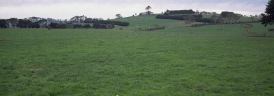 SW40 Landscape |
Soil Profile Morphology:
Surface Soil
| A11 | 0-25 cm | Black (10YR2/1); light fine sandy clay loam; weak to moderate coarse blocky structure; weak consistence moist; pH 5.4: | 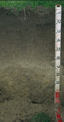 SW40 Profile |
| A12 | 25-40 cm | Very dark brown (10YR2/2); fine sandy clay loam; weak coarse blocky structure; weak consistence moist; pH 5.5: | |
| A21 | 40-60 cm | Brown (10YR5/3); fine sandy clay loam; weakly structured; weak consistence moist; pH 5.3: | |
| A22 | 60-75 cm | Pale brown (10YR6/3); fine sandy loam; weakly structured; firm consistence moist; pH 5.1: | |
| Subsoil | |||
| B21 | 75-90 cm | Pale brown (10YR6/3) with brownish yellow (10YR6/6) mottles; fine sandy clay; weak to moderate medium blocky structure; firm consistence moist; pH 5.1: | |
| B22 | 90+ cm | Grey (10YR5/1) with yellowish brown (10YR5/8) mottles; fine sandy clay; strong coarse blocky, parting to moderate to strong medium blocky structure; shiny faced peds; firm consistence moist; contains very few (2%) quartz fragments (2-5 mm in size); pH 5.0. |
Soil Profile Characteristics:
pH | Salinity Rating | |||
Surface (A11 horizon) | Strongly Acid | Moderate | Non-Sodic | None |
Subsoil (B21 horizon) | Strongly Acid | Low-Moderate | Non-Sodic | None |
Deeper Subsoil (at 90+ cm) | Strongly Acid | Low-Moderate | Non-Sodic | None |
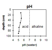 The whole profile is strongly acid throughout. | 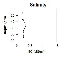 The profile has a low to moderate salinity rating throughout. | 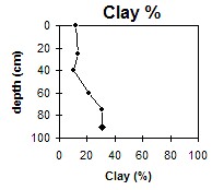 The clay content increases gradually with depth. |
Horizon | Horizon Depth (cm) | pH (water) | pH (CaCl2) | EC (dS/m) | NaCl % | Exchangeable Cations | |||
Ca | Mg | K | Na | ||||||
meq/100g | |||||||||
A11 | 0-25 | 5.4 | 4.7 | 0.23 | 0.03 | 3.8 | 1.2 | 0.2 | 0.3 |
A12 | 25-40 | 5.5 | 4.8 | 0.23 | 0.04 | 1.4 | 0.9 | 0.1 | 0.1 |
A21 | 40-60 | 5.3 | 4.7 | 0.35 | 0.07 | 0.6 | 0.6 | 0.05 | 0.05 |
A22 | 60-75 | 5.1 | 4.6 | 0.26 | 0.06 | 0.5 | 1.9 | <0.1 | 0.2 |
B21 | 75-90 | 5.1 | 4.5 | 0.27 | 0.07 | 0.9 | 0.6 | <0.1 | 0.05 |
B22 | 90+ | 5 | 4.4 | 0.26 | 0.06 | 0.3 | 2.9 | <0.1 | 0.4 |
Horizon | Horizon Depth (cm) | Field Capacity pF2.5 | Wilting Point pF4.2 | Acidity meq/100g | Oxidisable Organic Carbon % | Coarse Sand (0.2- 2.0 mm) | Fine Sand (0.02- 0.2 mm) | Silt (0.002- 0.02 mm) | Clay (<0.002 mm) |
A11 | 0-25 | 26.4 | 10.7 | 4.8 | 26 | 38 | 17 | 12 | |
A12 | 25-40 | 17.4 | 5.3 | 28 | 40 | 18 | 13 | ||
A21 | 40-60 | 16 | 3.1 | 29 | 43 | 20 | 10 | ||
A22 | 60-75 | 20.5 | 7.3 | 25 | 38 | 15 | 21 | ||
B21 | 75-90 | 25.2 | 11.2 | 6.5 | 22 | 33 | 15 | 31 | |
B22 | 90+ | 25.7 | 11 | 6.7 | 21 | 34 | 12 | 31 |
Profile Described By: Mark Imhof and Austin Brown (June 1998).
© State of Victoria (Agriculture Victoria) 1996 - .

This work, Victorian Resources Online, is licensed under a Creative Commons Attribution 4.0 licence. You are free to re-use the work under that licence, on the condition that you credit the State of Victoria (Agriculture Victoria) as author, indicate if changes were made and comply with the other licence terms.
The licence does not apply to ‘branding’ or some ‘images or photographs’ that may be owned by third parties. We ask you to seek prior approval to use images using the VRO feedback form. Access to higher quality images can also be provided on request.
This page was last updated on .