
SW111
Location: Mt Gellibrand.
Australian Soil Classification: Vertic (& Calcic), Black DERMOSOL (clayey surface).
General Landscape Description: Flat crest of Mt Gellibrand.
Site Description: Grazing paddock.
Geology: Late Quaternary basaltic scoria.
Soil Type: “Mountain Soil” Leeper et al. (1936)
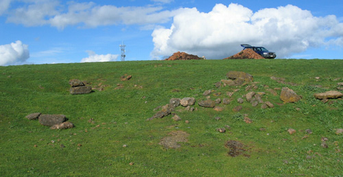 SW111 Landscape |
Soil Profile Morphology:
Surface Soil
| A1 | 0-15 cm | Very dark grey (10YR3/1); medium clay; strong medium to fine polyhedral structure; strong consistence dry; abundant roots; pH 6.4; clear change to: | 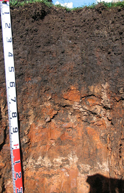 SW111 Profile SW111 Profile |
| Subsoil | |||
| B21 | 15-30 cm | Black (10YR2/1); heavy clay; strong medium to fine sub-angular blocky structure; strong consistence dry; pH 6.7; clear change to: | |
| B22 | 30-55 cm | Black (10YR2/1) with few dusky red (2.5YR3/4) and reddish brown (5YR4/3) mottles; heavy clay; strong coarse to medium sub-angular blocky structure; strong consistence dry; slickensides present; shiny faced peds; pH 7.5; clear change to: | |
| B23 | 55-70/80 cm | Black (10YR2/1) with few brown (7.5YR5/4 and 4/4) mottles; heavy clay; strong coarse to medium sub-angular blocky structure; strong consistence dry; slickensides present; shiny faced peds; includes some weathered scoria; pH 8.8; clear change to: | |
| B24k | 70/80-85 cm | Very dark grey (10YR3/1) with brown (7.5YR4/4) mottles; medium clay; many (20%) semi-hard calcareous nodules; abrupt and wavy change to; pH 9: | |
| C1 | 85-100/105 cm | Mainly (>90%) weathered scoria with narrow bands of structured clay: | |
| 2B1 | 100/105-110 cm | Strong brown (7.5YR5/6); strong medium sub-angular blocky structure; clay; dark stains along ped faces: | |
| 2B2k | 110-115 cm | Many fine-earth carbonates and structured clay material: | |
| 2BC2 | 115+ cm | Successive layers of scoria with sometimes interceding layers of structured clay material. | |
 | Scoria - Vesicular glassy fragments of basaltic composition, partly cemented, generally permeable and readily weathered can be seen exposed in a small excavation west of soil pit. |
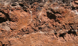
Key Profile Features:
|
Soil Profile Characteristics:
pH | Salinity Rating | |||
Surface (A1 horizon) | Slightly Acid | Low | Non-Sodic | None1 |
Subsoil (B21 horizon) | Slightly Acid | Very Low | Non-Sodic | Moderate2 |
Deeper subsoil (at 55-80 cm) | Strongly Alkaline | Low-Medium | Sodic | None3 |
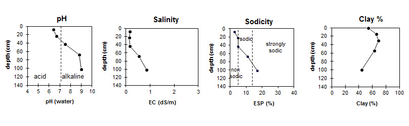
| The surface (A) horizon and upper subsoil are slightly acid. The deeper subsoil is strongly alkaline. | The salinity rating is low in the surface. The subsoil is very low becoming moderate at depth. | The surface and upper subsoil is non sodic. The deeper subsoil at 55-80 cm becomes sodic and strongly sodic at 1 m. |
|
Horizon | Horizon Depth (cm) | pH (water) | pH (CaCl2) | EC dS/m | NaCl % | Total Nitrogen % | Organic Carbon % | Exchangeable Cations | |||
Ca | Mg | K | Na | ||||||||
meq/100g | |||||||||||
A1 | 0-15 | 6.4 | 5.7 | 0.16 | 0.45 | 5.5 | 18 | 14 | 3 | 1.4 | |
B21 | 15-30 | 6.7 | 5.8 | 0.15 | 0.25 | 3.1 | 19 | 17 | 2.8 | 1.9 | |
B22 | 30-55 | 7.5 | 6.6 | 0.17 | 0.20 | 2.5 | 21 | 21 | 2.2 | 3 | |
B23 | 55-80 | 8.8 | 8.2 | 0.55 | 0.04 | 21 | 28 | 1.6 | 6.1 | ||
B24k | 100-105 | 9 | 8.9 | 0.86 | 0.07 | 18 | 41 | 1.4 | 12 | ||
Horizon | Horizon Depth (cm) | Extractable Iron % | Extractable Aluminium % | Exchangeable Aluminium mg/kg | Exchangeable Acidity meq/100g | Field Capacity pF2.5 | Wilting Point pF4.2 | Coarse Sand (0.2-2.0 mm) | Fine Sand (0.02-0.2 mm) | Silt (0.002-0.02 mm) | Clay (<0.002 mm) |
A1 | 0-15 | 2.2 | 0.23 | 15 | 16 | 44.9 | 33.5 | 11 | 11 | 14 | 54 |
B21 | 15-30 | 2.3 | 0.26 | 15 | 48.4 | 35.8 | 7 | 10 | 10 | 66 | |
B22 | 30-55 | 2.3 | 0.25 | 11 | 57.9 | 37.9 | 6 | 10 | 10 | 69 | |
B23 | 55-80 | 57.9 | 41.2 | 4 | 9 | 11 | 63 | ||||
B24k | 100-105 | 4 | 12 | 31 | 44 |
Notes: Geology and landform described by Bernie Joyce.
Profile Described By: Mark Imhof, John Martin, Jack Holland and Bernie Joyce (October 2004).
Reference:
Leeper GW, Nicholls A and Wadham SM (1936). Soil and Pasture Studies in the Mount Gellibrand area, Western District of Victoria. Proceedings Royal Society Victoria, 49.
© State of Victoria (Agriculture Victoria) 1996 - .

This work, Victorian Resources Online, is licensed under a Creative Commons Attribution 4.0 licence. You are free to re-use the work under that licence, on the condition that you credit the State of Victoria (Agriculture Victoria) as author, indicate if changes were made and comply with the other licence terms.
The licence does not apply to ‘branding’ or some ‘images or photographs’ that may be owned by third parties. We ask you to seek prior approval to use images using the VRO feedback form. Access to higher quality images can also be provided on request.
This page was last updated on .