
SW110
Location: Mt Gellibrand.
Australian Soil Classification: Vertic (& Calcic), Mottled-Mesonatric, Grey SODOSOL (very deep soil profile).
General Landscape Description: Lower part of a slope on the western side of Mt Gellibrand.
Site Description: Grazed area adjacent to cropping area, low slope angle, westerly aspect.
Geology: Almost entirely quartz sand, of uncertain origin - possibly a Tertiary quartz-rich marine sediment. Soil in the pit has also been subject to soil creep and wash from weathering scoria slopes above.
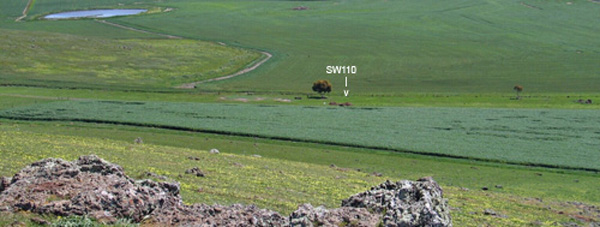 SW110 Landscape |
Soil Profile Morphology:
Surface Soil
| A1 | 0-5 cm | Very dark greyish brown (10YR3/2); sandy clay loam; moderate fine-very fine polyhedral structure; weak to firm consistence dry; abundant roots throughout; pH 5.9: | 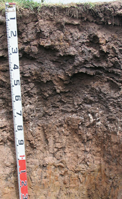 SW110 Profile |
| A2 | 5-12 cm | Brown (7.5YR4/3); rusty root channel mottling; sandy clay loam; weak medium blocky structure; some capping on the columnar structure below; firm to very firm consistence dry; abundant roots throughout; pH 7.3; abrupt change to: | |
| Subsoil | |||
| B21 | 12-30 cm | Dark greyish brown (10YR4/2) with many brown (7.5YR4/4) and dark yellowish brown (10YR4/4) mottles; dark colour along ped faces; heavy clay; moderate to strong very coarse prismatic, parting to strong coarse blocky structure; some columnar structure in patches; very strong consistence dry; pH 6.8: | |
| B22 | 30-45/55 cm | Very dark greyish brown (10YR3/2); heavy clay; strong very coarse prismatic, parting to strong coarse blocky structure; few soft manganese segregations and stains; very few medium (10 mm in size) ferromanganiferous nodules; slickensides present; very strong consistence dry; abrupt and wavy change to; pH 8.4: | |
| B23k | 45/55-90 cm | Dark greyish brown (2.5Y4/2); light medium clay; strong coarse blocky, parting to medium blocky structure; fine-earth carbonates common; slickensides present; pH 9.6: | |
| 2A1 | 90-110 cm | Brown (7.5YR5/4) and dark grey (10YR4/1); sandy loam; moderate medium blocky, parting to fine blocky structure; few coarse (10 mm in size) ferromanganiferous nodules; sand common along cracks; pH 9.7: | |
| 2B1 | 110-130/140 cm | Brown (7.5YR5/4) with yellowish red (5YR4/6) and yellowish brown (10YR5/6) mottles; sandy clay loam (contains well structured light yellowish brown (2.5Y6/3) clay aggregates mixed with sand); strong medium lenticular parting to fine lenticular structure; pH 9.4: | |
| 2B2 | 130/140-180 cm | Light yellowish brown (2.5Y6/3) with brownish yellow (10YR6/6) mottles; light medium clay; strong medium to fine lenticular structure; weak to firm consistence moist; few fine-earth carbonates; some red (10R5/6) soft ochre-like clayey pebbles present in patches; pH 9.4. | |
Key Profile Features:
- Strong texture contrast between surface (A) horizons and subsoil (B21) horizon.
- Vertic features (slickensides, lenticular peds) in subsoil.
- Dense and coarsely structured subsoil (columnar in some areas).
pH | Salinity Rating | |||
Surface (A1 horizon) | Moderately Acid | Low | Sodic | None |
Subsoil (B21 horizon) | Slightly Acid | Low | Sodic | Strong1 |
Deeper subsoil (at 80-110 cm) | Very Strongly Alkaline | High | Strongly Sodic | Slight2 |
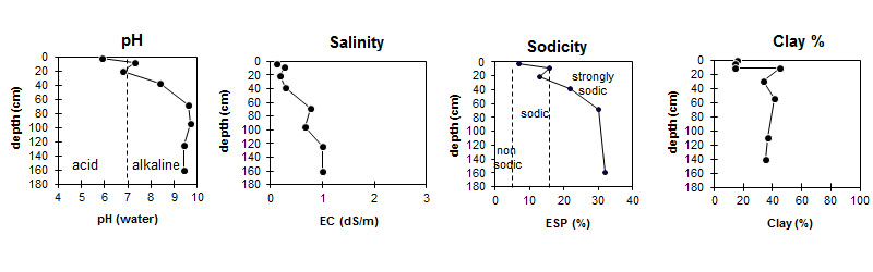

| The surface (A) horizon is moderately acid. The upper subsoil is slightly acid becoming alkaline by 30 cm depth and very strongly alkaline at depth. |
|
|
|
Horizon | Horizon Depth (cm) | pH (water) | pH (CaCl2) | EC dS/m | NaCl % | Total Nitrogen % | Organic Carbon % | Exchangeable Cations | |||
Ca | Mg | K | Na | ||||||||
meq/100g | |||||||||||
A1 | 0-5 | 5.9 | 5.1 | 0.12 | 0.45 | 6 | 5.6 | 4.2 | 0.61 | 0.91 | |
A2 | 5-12 | 7.3 | 6.8 | 0.27 | 0.01 | 2.1 | 3.5 | 0.4 | 1.8 | ||
B21 | 12-30 | 6.8 | 5.7 | 0.18 | 5.2 | 12 | 1.5 | 4.3 | |||
B22 | 30-55 | 8.4 | 7.4 | 0.29 | 0.02 | 5.4 | 15 | 1.3 | 6.1 | ||
B23k | 55-80 | 9.6 | 8.7 | 0.77 | 0.08 | 6 | 19 | 0.9 | 11 | ||
2A1 | 80-110 | 9.7 | 8.9 | 0.66 | 0.08 | - | - | - | - | ||
2B1 | 110-140 | 9.4 | 8.7 | 1 | 0.16 | - | - | - | - | ||
2B2 | 140-180 | 9.4 | 8.7 | 1 | 0.18 | 3.9 | 14 | 0.8 | 8.6 | ||
Horizon | Horizon Depth (cm) | Extractable Aluminium % | Extractable Iron % | Exchangeable Aluminium mg/kg | Exchangeable Acidity meq/100g | Coarse Sand (0.2-2.0 mm) | Fine Sand (0.02-0.2 mm) | Silt (0.002-0.02 mm) | Clay (<0.002 mm) |
A1 | 0-5 | <10 | 12 | 42 | 24 | 9 | 16 | ||
A2 | 5-12 | 4.6 | 47 | 28 | 9 | 14 | |||
B21 | 12-30 | 0.25 | 1.9 | 11 | 26 | 19 | 6 | 45 | |
B22 | 30-55 | 0.16 | 1.4 | 34 | 22 | 8 | 34 | ||
B23k | 55-80 | 28 | 18 | 8 | 41 | ||||
2A1 | 80-110 | - | - | - | - | ||||
2B1 | 110-140 | 40 | 12 | 4 | 37 | ||||
2B2 | 140-180 | 42 | 14 | 5 | 35 |
Notes: Geology and landform described by Bernie Joyce.
Profile Described By: Mark Imhof, John Martin, Jack Holland and Bernie Joyce (October 2004).
© State of Victoria (Agriculture Victoria) 1996 - .

This work, Victorian Resources Online, is licensed under a Creative Commons Attribution 4.0 licence. You are free to re-use the work under that licence, on the condition that you credit the State of Victoria (Agriculture Victoria) as author, indicate if changes were made and comply with the other licence terms.
The licence does not apply to ‘branding’ or some ‘images or photographs’ that may be owned by third parties. We ask you to seek prior approval to use images using the VRO feedback form. Access to higher quality images can also be provided on request.
This page was last updated on .