
SW109
Location: Mt Gellibrand.
Australian Soil Classification: Vertic (& Hypercalcic), Mottled-Mesonatric, Black SODOSOL (very deep soil profile).
General Landscape Description: Lower slope of Mt Gellibrand, northerly aspect.
Site Description: Grazing paddock. A flat area just at the foot of a steeper slope, with a basalt dyke or flow just up slope. Subject to soil creep and wash from above.
Geology: Late Quaternary basalt (Bartley 1984).
Soil Type: “Low slopes (lighter type)” (Leeper et al., 1936)
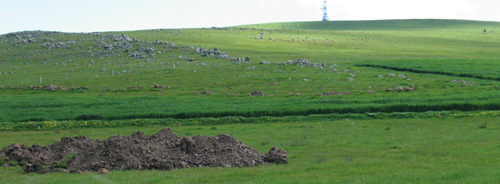
SW109 Landscape
Soil Profile Morphology:
Surface Soil
| A1 | 0-15 cm | Very dark greyish brown (10YR3/2); fine sandy loam; firm consistence dry; pH 6; clear change to: | 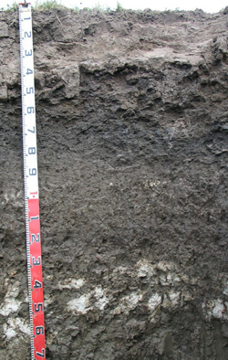 SW109 Profile SW109 Profile |
| A2 | 25-40 cm | Light grey (10YR7/1 dry) with yellowish brown (10YR5/4) rusty root channel mottling; conspicuously bleached; sandy loam; firm to very firm consistence dry; pH 6.2; sharp and wavy change to: | |
| Subsoil | |||
| B21 | 25-40 cm | Very dark grey (10YR3/1) with many brown (7.5YR5/4) rusty mottles; medium clay; strong coarse blocky structure; in parts there is strong very coarse columnar structure, with bleached capping associated with domes; strong consistence dry; pH 6.4; clear change to: | |
| B22 | 40-60 cm | Very dark grey (10YR3/1) with many brown (10YR5/4) mottles; medium heavy clay; strong coarse blocky, parting to moderate medium sub-angular blocky structure; strong consistence dry; slickensides present; pH 7.9; clear change to: | |
| B23 | 60-80 cm | Very dark grey (10YR3/1); heavy clay; strong coarse polyhedral structure; very firm consistence dry; slickensides present; pH 8.6; clear change to: | |
| B24 | 80-100 cm | Grey (2.5Y5/1); heavy clay; strong coarse prismatic, parting to strong coarse blocky structure; very firm consistence dry; few fine-earth carbonates and fine calcareous nodules (2-4 mm in size); slickensides present; pH 9.3; clear change to: | |
| B25 | 100-130 cm | Grey (10YR5/1) with very few yellowish brown (10YR5/6) mottles; medium heavy clay; strong coarse prismatic, parting to strong coarse sub-angular blocky structure; very firm consistence moist; few fine-earth carbonates and very few very coarse (up to 30 mm in size) ferruginous nodules; few weathered ferruginous basalt fragments (20 mm in size); slightly effervescent; smooth faced peds; pH 9.3; clear change to: | |
| B26k | 130-160 cm | Greyish brown (2.5Y5/2); heavy clay; strong coarse polyhedral structure; firm consistence moist; many fine-earth carbonates and semi-hard carbonate nodules, few very coarse (10-30 mm in size) ferruginous nodules; very few isolated ferruginous basalt cobbles (100 mm in size); visible carbonates; pH 9.7; gradual change to: | |
| B27k | 130-160 cm | Greyish brown (2.5Y5/2); heavy clay; strong coarse polyhedral structure; very firm consistence moist; very few fine (1-2 mm in size) soft and hard manganese nodules and few coarse (5-15 mm in size) ferruginous nodules; very few very fine (<1 mm in size) quartz fragments; slightly audible effervescence. | |
- Strong texture contrast between surface (A) horizons and subsoil (B21) horizon.
- Dense and coarsely structured upper subsoil (columnar in some areas).
- Accumulations of calcium carbonate in deeper subsoil.
- Vertic features (slickensides, lenticular structure) in subsoil.

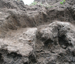
Domes / columnar structure evident in the B21 horizon in some areas.
Soil Profile Characteristics:
pH | Salinity Rating | |||
Surface (A1 horizon) | Moderately Acid | Low | Non-Sodic | None1 |
Subsoil (B21 horizon) | Slightly Acid | Low | Strongly Sodic | Strong2 |
Deeper subsoil (at 80-100 cm) | Very Strongly Alkaline | Moderate - High | Strongly Sodic | Strong2 |
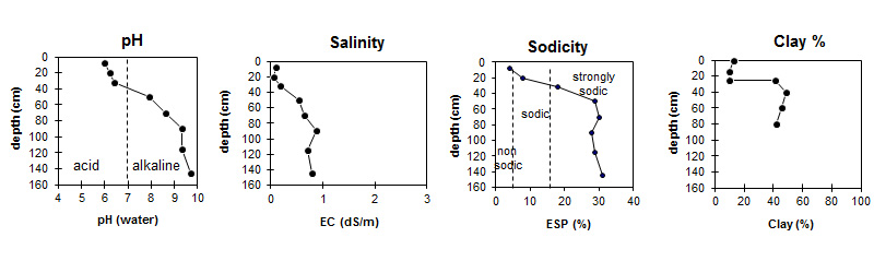
| The surface soil is moderately acid. The upper subsoil is slightly acid becoming very strongly alkaline at depth. |
|
| The clay content is moderate throughout the profile. |
Horizon | Horizon Depth (cm) | pH (water) | pH CaCl2 | EC dS/m | NaCl % | Total Nitrogen % | Organic Carbon % | Exchangeable Cations | |||
Ca | Mg | K | Na | ||||||||
meq/100g | |||||||||||
A1 | 0-15 | 6 | 5.2 | 0.1 | 0.21 | 2.9 | 2.9 | 2.3 | 0.24 | 0.59 | |
A2 | 15-25 | 6.2 | 4.9 | 0.06 | 0.94 | 1.3 | 0.1 | 0.59 | |||
B21 | 25-40 | 6.4 | 5.3 | 0.19 | 3.5 | 10 | 0.44 | 5.7 | |||
B22 | 40-60 | 7.9 | 6.9 | 0.54 | 0.08 | 5.9 | 18 | 0.7 | 10 | ||
B23 | 60-80 | 8.6 | 7.7 | 0.65 | 0.1 | 6.4 | 19 | 0.8 | 11 | ||
B24 | 80-100 | 9.3 | 8.6 | 0.87 | 0.11 | 6.2 | 25 | 0.8 | 12 | ||
B25 | 100-130 | 9.3 | 8.6 | 0.7 | 0.09 | 5.2 | 21 | 0.7 | 11 | ||
B26k | 130-160 | 9.7 | 9 | 0.8 | 0.09 | 4.9 | 17 | 0.5 | 10 | ||
Horizon | Horizon Depth (cm) | Extractable Iron % | Extractable Aluminium % | Exchangeable Aluminium mg/kg | Exchangeable Acidity meq/100g | Field Capacity pF2.5 | Wilting Point pF4.2 | Coarse Sand (0.2-2.0 mm) | Fine Sand (0.02-0.2 mm) | Silt (0.002-0.02 mm) | Clay (<0.002 mm) |
A1 | 0-15 | <10 | 7.3 | - | 9.1 | 35 | 37 | 10 | 13 | ||
A2 | 15-25 | <10 | 4.2 | 27.8 | 4.2 | 33 | 42 | 10 | 10 | ||
B21 | 25-40 | 1.4 | 0.21 | <10 | 12 | - | 19.9 | 22 | 26 | 8 | 41 |
B22 | 40-60 | 1.2 | 0.18 | 40.5 | 26.7 | 17 | 22 | 8 | 49 | ||
B23 | 60-80 | 47.2 | 28.1 | 18 | 23 | 10 | 46 | ||||
B24 | 80-100 | 52.2 | 29 | 17 | 22 | 14 | 42 | ||||
B25 | 100-130 | ||||||||||
B26k | 130-160 |
Notes: Geology and landform described by Bernie Joyce.
Profile Described By: Mark Imhof, John Martin, Jack Holland and Bernie Joyce (October 2004).
Reference:
Leeper GW, Nicholls A and Wadham SM (1936). Soil and Pasture Studies in the Mount Gellibrand area, Western District of Victoria. Proceedings Royal Society Victoria, 49.
© State of Victoria (Agriculture Victoria) 1996 - .

This work, Victorian Resources Online, is licensed under a Creative Commons Attribution 4.0 licence. You are free to re-use the work under that licence, on the condition that you credit the State of Victoria (Agriculture Victoria) as author, indicate if changes were made and comply with the other licence terms.
The licence does not apply to ‘branding’ or some ‘images or photographs’ that may be owned by third parties. We ask you to seek prior approval to use images using the VRO feedback form. Access to higher quality images can also be provided on request.
This page was last updated on .