
SW108
Location: Mt Gellibrand.
Australian Soil Classification: Endocalcareous-Endohypersodic, Self-mulching, Black VERTOSOL
General Landscape Description: Gently undulating plain with stony rises.
Site Description: A flat area at the base of a stony rise. It is subject to deposition by soil creep and wash of soil material eroded from the rise above, as well as possible reworking by water in swamp conditions, with the addition of organic material.
Geology: Late Quaternary basalt (Bartley 1984).
Soil Type: “Thistle-zone soil” (Leeper et al, 1936)
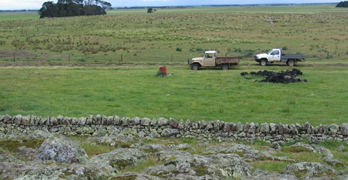
| SW108 Landscape |
Soil Profile Morphology:
Surface Soil
| A1 | 0-20 cm | Black (10YR2/1); surface cracking; medium clay; strong coarse to medium sub-angular blocky structure; firm consistence slightly moist; non sticky; few fine (0.5 – 1 mm in size) well-rounded coloured quartz fragments; fine roots abundant; pH 6.7; clear change to: | 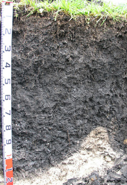 SW108 Profile SW108 Profile |
| Subsoil | |||
| B21 | 20-50 cm | Very dark greyish brown (10YR3/2); medium heavy clay; strong medium to fine angular blocky structure as well as lenticular structure; shiny faced peds; firm consistence slightly moist, slightly sticky; few fine (0.5 – 1 mm in size) quartz fragments; fewer roots than above; pH 8.7; gradual change to: | |
| B22 | 50-70 cm | Black (10YR2/1); medium heavy clay; strong medium to fine lenticular structure; strong consistence; few (2%) fine (0.5 – 1 mm) quartz fragments; trace of calcium carbonate; root density similar to above; pH 8.9; gradual change to: | |
| B23 | 70-100 cm | Very dark grey (10YR3/1); heavy clay; strong fine blocky structure; strong consistence; slickensides; few fine (0.5 – 1 mm in size) quartz fragments; few fine-earth carbonates; few roots; pH 9; clear and wavy change to: | |
| B24k | 100-130 cm | Dark greyish brown (2.5Y4/2); few soft manganese stains within clay; very many soft fine-earth carbonates; basalt inclusions; pH 9.4: | |
| C | 130+ cm | Weathered basalt with weathered black earth carbonate coatings. | |
Key Profile Features:
- Soil profile cracks strongly when dry, with surface cracks forming.
- Clay texture throughout the soil profile.
- Significant shrinking and swelling occurs during wetting and drying cycles.
- Accumulations of calcium carbonate in the deeper subsoil.
- Vertic features (slickensides, lenticular structure) in the subsoil.
pH | Salinity Rating | |||
Surface (A1 horizon) | Slightly Acid | Very Low | Non-Sodic | None |
Subsoil (B21 horizon) | Strongly Alkaline | Very Low | Non-Sodic | None1 |
Deeper subsoil (at 70-100 cm) | Strongly Alkaline | Low-Medium | Sodic | Slight2 |

| The surface soil is slightly acid. The subsoil is strongly alkaline throughout |
|
|
|
Horizon | Horizon Depth (cm) | pH (water) | pH (CaCl2) | EC dS/m | NaCl % | Total Nitrogen % | Organic Carbon % | Exchangeable Cations | |||
Ca | Mg | K | Na | ||||||||
meq/100g | |||||||||||
A1 | 0-20 | 6.7 | 6.1 | 0.17 | 0.33 | 4.2 | 24 | 14 | 1.3 | 1.1 | |
B21 | 20-50 | 8.7 | 8 | 0.21 | 0.1 | 1.8 | 30 | 21 | 0.66 | 2.4 | |
B22 | 50-70 | 8.9 | 8.1 | 0.25 | 0.1 | 1.9 | 26 | 25 | 0.63 | 4.1 | |
B23 | 70-100 | 9 | 8.3 | 0.43 | 0.02 | 21 | 36 | 0.7 | 7.2 | ||
B24k | 100-130 | 9.4 | 8.6 | 0.52 | 0.02 | 10 | 28 | 0.4 | 7 | ||
Horizon | Horizon Depth (cm) | Extractable Iron % | Exchangeable Acidity meq/100g | Field Capacity pF2.5 | Wilting Point pF4.2 | Coarse Sand (0.2-2.0 mm) | Fine Sand (0.02-0.2 mm) | Silt (0.002-0.02 mm) | Clay (<0.002 mm) |
A1 | 0-20 | 0.8 | 11 | 49 | 29 | 8 | 21 | 12 | 47 |
B21 | 20-50 | 0.64 | 55 | 31 | 7 | 18 | 12 | 56 | |
B22 | 50-70 | 56 | 30 | 6 | 17 | 16 | 53 | ||
B23 | 70-100 | 59 | 35 | ||||||
B24k | 100-130 |
Notes: Geology and landform described by Bernie Joyce (DPI Pers. Com.).
Profile Described By: Mark Imhof, John Martin, Jack Holland and Bernie Joyce (October 2004).
Reference:
Leeper GW, Nicholls A and Wadham SM (1936). Soil and Pasture Studies in the Mount Gellibrand area, Western District of Victoria. Proceedings Royal Society Victoria, 49.
© State of Victoria (Agriculture Victoria) 1996 - .

This work, Victorian Resources Online, is licensed under a Creative Commons Attribution 4.0 licence. You are free to re-use the work under that licence, on the condition that you credit the State of Victoria (Agriculture Victoria) as author, indicate if changes were made and comply with the other licence terms.
The licence does not apply to ‘branding’ or some ‘images or photographs’ that may be owned by third parties. We ask you to seek prior approval to use images using the VRO feedback form. Access to higher quality images can also be provided on request.
This page was last updated on .