
SFS22
Location: Rocklea
Australian Soil Classification: Vertic (& Calcic), Mottled-Mesonatric, SODOSOL
General Landscape Description: Gently undulating coastal plain with very low relief.
Site Description: Simple slope (1-2%) with southerly aspect.
Land Use: Pasture / crop rotations. Southern Farming Systems (SFS) trial site.
Geology: Neogene sediments (Hanson Plain Sand).
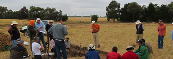
SFS22 Landscape
Soil Profile Morphology:
| Surface Soil | 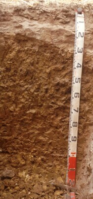 SFS22 profile | ||
| Ap | 0-10 cm | Dark brown (10YR3/3); loamy sand; apedal structure; loose with some weak fragments; pH 6.0; abrupt change to: | |
| A2(e) | 10-20/35 cm | Dark yellowish brown (10YR4/4), pale brown (10YR6/3 dry) and light yellowish brown (10YR6/4) conspicuously bleached (10YR7/3 dry) ; sandy loam; few coarse buckshot/ferruginous gravel in thicker zones of A2; apedal structure; firm consistence dry; pH 5.7; sharp and wavy change to: NOTE: Horizon is of variable thickness. It is more bleached where it is thicker and closer to the A2/B21 boundary. | |
| Subsoil | |||
| B21t | 20/35-65 cm | Brown (10YR4/3) ped faces with yellowish brown (10YR5/6) matrix with dark yellowish brown (10YR4/6) mottles; medium clay; coarse prismatic (some peds tending to have domed tops), parting to coarse (20 mm) angular blocky, polyhedral as well as lenticular structure; smooth faced peds; pH 7.2; gradual or diffuse change to: | |
| B22t | 65-95 cm | Dark yellowish brown (10YR4/6) matrix and yellowish red (5YR4/6) ped surfaces; medium clay; angular blocky and lenticular structure; many vertic features; pH 8.7; clear change to: | |
| B23ss | 95-120+ cm | Strong brown (7.5YR5/8) matrix with yellowish red (5YR4/6) ped surfaces/infill; light clay; contains soft yellow (10YR7/6) calcium carbonate; visible effervescence; pH 9.3. NOTE: Thick vertical lenticular peds in the subsoil. | |
 Part of a lenticular ped found within the subsoil. |  A fragment from the deeper subsoil B23k, note the calcium carbonate. |
- Strong texture contrast between surface (A) horizons and subsoil (B21) horizon.
- Lateral variation in soil profile due to gilgai microrelief (e.g. variations in depth of subsurface A2 horizon; variation in amount of ironstone gravel).
Soil Profile Characteristics:
pH | Salinity Rating | |||
Surface (A1 horizon) | Moderately Acid | Low | Non-Sodic | Minimal Aggredation |
Subsoil (B21 horizon) | Near Neutral | Low | Strongly Sodic | Moderate1 |
Deeper subsoil (at 95-120 cm) | Very Strongly Alkaline | Medium | Strongly Sodic | Slight2 |
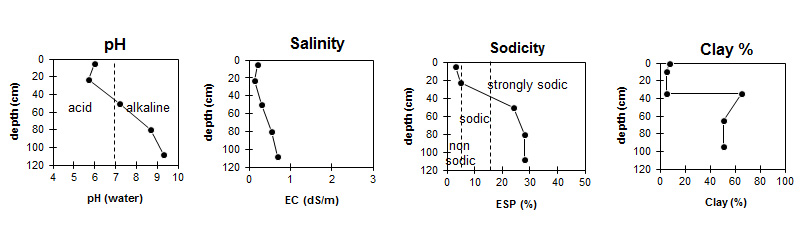
| The pH in the surface is moderately acid. The pH in the upper subsoil is near neutral becoming very strongly alkaline with depth. |
| The surface is non sodic. The subsoil is strongly sodic. | The clay content in the surface is low and sharply increases at the surface / subsoil interface. |
Horizon | Horizon Depth (cm) | pH (water) | pH (CaCl2) | EC dS/m | NaCl % | Exchangeable Cations | |||
Ca | Mg | K | Na | ||||||
meq/100g | |||||||||
Ap | 0-10 | 6.0 | 5.6 | 0.21 | 6.1 | 1.2 | 0.50 | 0.41 | |
A2 | 10-35 | 5.7 | 5.3 | 0.14 | 1.1 | 0.46 | <0.05 | 0.19 | |
B21 | 35-65 | 7.2 | 6.4 | 0.31 | 0.03 | 4.9 | 7.8 | 0.4 | 4.2 |
B22 | 65-95 | 8.7 | 7.9 | 0.54 | 0.06 | 4.6 | 10 | 0.4 | 5.7 |
B23 | 95-120 | 9.3 | 8.6 | 0.69 | 0.07 | 4.7 | 9.9 | 0.4 | 5.6 |
Horizon | Horizon Depth (cm) | Oxidisable Organic Carbon % | Total Nitrogen % | Exchangeable Aluminium mg/kg | Exchangeable Acidity meq/100g | Field Capacity pF2.5 | Wilting Point pF4.2 | Coarse Sand (0.2-2.0 mm) | Fine Sand (0.02-0.2 mm) | Silt (0.002-0.02 mm) | Clay (<0.002 mm) |
Ap | 0-10 | 1.9 | 0.27 | <10 | 6.3 | 15 | 9 | 14 | 63 | 8 | 8 |
A2 | 10-35 | <10 | 1.7 | 11 | 2 | 16 | 68 | 9 | 5 | ||
B21 | 35-65 | 36 | 23 | 5 | 23 | 4 | 65 | ||||
B22 | 65-95 | 39 | 20 | 6 | 35 | 5 | 51 | ||||
B23 | 95-120 |
Management Considerations:
Whole Profile
- Plant available water capacity (PAWC) is considered to be very low (estimated at 33 mm) in the upper 30 cm of this soil profile. Effective rooting depth (ERD) is restricted to 30 cm due to the highly sodic subsoils.
- The texture contrast and the sodic (ESP is around 25%) subsoil restricts drainage and the soils readily become waterlogged in winter.
- The sandy topsoil is very susceptible to soil structure decline; the weak aggregation is readily destroyed by cultivation and the soils are prone to compaction. Bare soil is vulnerable to structural breakdown by rain (slaking and sealing) and to erosion by water. In dry conditions these soils are known to be vulnerable to wind erosion.
- Plough pans are common in these soils. Disruption of pans by tillage is short lived unless controlled traffic is deployed in cropping situations. Raised beds have been used with some degree of success in these soils but the unstable topsoils do not lend themselves well to bed survival.
- Other parts of the paddock were reported as having a high gravel or buckshot content though little was found in this pit.
- See also SFS19 for related soil. Principle difference between this and SFS19 is the presence of calcareous material at 1 metre and the higher sodicity (SFS19 is only marginally sodic).
Profile Describe By: Richard MacEwan (May 1999).
© State of Victoria (Agriculture Victoria) 1996 - .

This work, Victorian Resources Online, is licensed under a Creative Commons Attribution 4.0 licence. You are free to re-use the work under that licence, on the condition that you credit the State of Victoria (Agriculture Victoria) as author, indicate if changes were made and comply with the other licence terms.
The licence does not apply to ‘branding’ or some ‘images or photographs’ that may be owned by third parties. We ask you to seek prior approval to use images using the VRO feedback form. Access to higher quality images can also be provided on request.
This page was last updated on .