
SFS2
Location: Gnarwarre.
Australian Soil Classification: Endocalcareous, Self-Mulching, Black VERTOSOL
General Landscape Description: Low rise on an undulating plain.
Site Description: Southern edge of Gnarwarre Farming Systems trial site raised bed cropping.
Geology: Quaternary Basalt - Newer Volcanics
Map Unit: Gnarwarre A soil (Adcock, 1998).
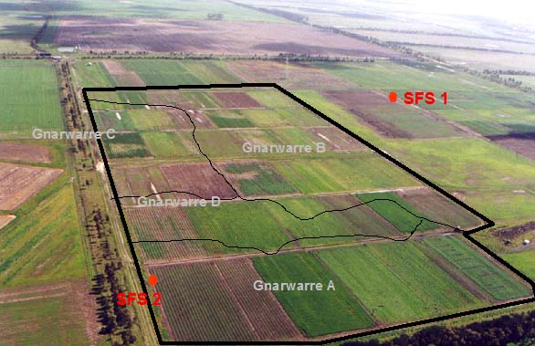
SFS2 Landscape. Also shows the Map Units within the Gnarwarre SFS trial site.
Soil Profile Morphology:
Surface Soil
| Ap | 0-20cm | Black (10YR2/1); self-mulching and cracking surface condition; light medium clay; strongly pedal; pH 6.0; clear change to: | 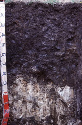 SFS2 Profile. |
| Subsoil | |||
| B21g | 20-50/70 cm | Black (10YR2/1) with abundant coarse dark greyish brown (2.5Y4/2) mottles as well as few fine to medium dark red (2.5YR4/8) and strong brown (7.5YR5/8) mottles; heavy clay; strong angular blocky and lenticular structure, parting to coarse polyhedral, parting to fine polyhedral structure; medium macropores common; shiny faced peds; pH 7.4; clear and wavy boundary to: | |
| B22gss | 50/70 –90 cm | Black (10YR2/1) with many coarse dark greyish brown (2.5Y4/2) mottles (increasing with size and abundance with depth); heavy clay; prominent slickensides; medium macropores common; pH 8.2; clear boundary to: | |
| B23k | 90+cm | Abundant calcium carbonate; highly calcareous; rounded dense basalt floaters; Field pH 9.5/10. | |
Key Profile Features:
- Surface cracking occurs when soil profile dries out.
- Clay texture throughout soil profile.
- Self-mulching surface condition.
- Vertic features (i.e. slickensides, lenticular peds) evident in subsoil.
Soil Profile Characteristics:
pH | Salinity Rating | |||
Surface (A1 horizon) | Moderately Acid | Low | Non-Sodic | None1 |
Subsoil (B21 horizon) | Slightly Alkaline | Low | Non-Sodic | None2 |
Deeper Subsoil | Moderately Alkaline | Low | Non-Sodic | None2 |
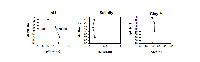
| The pH in the surface is moderately acid. The pH in the subsoil is slightly alkaline becoming moderately alkaline with depth. | The salinity rating is low throughout the profile. | The clay content is moderate throughout the profile. |
Horizon | Horizon Depth (cm) | pH (water) | pH (CaCl2) | EC dS/m | Exchangeable Cations | |||
Ca | Mg | K | Na | |||||
meq/100g | ||||||||
AP | 0-20 | 6 | 5.2 | 0.15 | 14 | 10 | 1.1 | 0.5 |
B21g | 20-50/70 | 7.4 | 6.4 | 0.12 | 14 | 13 | 0.93 | 0.85 |
B22g | 50/70-90 | 8.2 | 7.2 | 0.17 | 15 | 15 | 0.86 | 1.4 |
Horizon | Horizon Depth (cm) | Exchangeable Aluminium mg/kg | Exchangeable Acidity meq/100g | Oxidisable Organic Carbon % | Total Nitrogen % | Field Capacity pF2.5 | Wilting Point pF4.2 | Coarse Sand (0.2-2.0 mm) | Fine Sand (0.02-0.2 mm) | Silt (0.002-0.02 mm) | Clay (<0.002 mm) |
AP | 0-20 | <10 | 11 | 2.3 | 0.19 | 40.6 | 22.9 | 11 | 27 | 13 | 39 |
B21g | 20-50/70 | 5.9 | 42.6 | 22.5 | 11 | 28 | 13 | 46 | |||
B22g | 50/70-90 | 4.3 | 44.9 | 24.1 | 11 | 27 | 13 | 47 |
Management Considerations:
- The self mulching properties and high chemical fertility of this soil make it very favourable for crop growth. The major limitation is waterlogging but this is being effectively managed in crops by the use of raised beds. This soil is extremely sticky when wet and prone to damage by hooves and by wheeled traffic. The self mulching behaviour lends a resilience to the soil which can readily recover from structural damage in the surface.
- Plant available water capacity (PAWC) is considered to be medium (estimated at 117 mm) in the upper 100 cm of this soil profile.
Profile Described By: Richard MacEwan (May 1999).
Reference:
Adcock D 1998. Gnarwarre Soil Survey. Centre for Environmental Management, University of Ballarat. unpublished.
© State of Victoria (Agriculture Victoria) 1996 - .

This work, Victorian Resources Online, is licensed under a Creative Commons Attribution 4.0 licence. You are free to re-use the work under that licence, on the condition that you credit the State of Victoria (Agriculture Victoria) as author, indicate if changes were made and comply with the other licence terms.
The licence does not apply to ‘branding’ or some ‘images or photographs’ that may be owned by third parties. We ask you to seek prior approval to use images using the VRO feedback form. Access to higher quality images can also be provided on request.
This page was last updated on .