
SFS19
Location: Teesdale.
Australian Soil Classification: Vertic (& Ferric), Mottled-Subnatric, Brown SODOSOL
General Landscape Description: Level Plain.
Site Description: Southern Farming Systems (SFS) raised bed site.
Land Use: Canola.
Geology: Moorabool Viaduct Formation
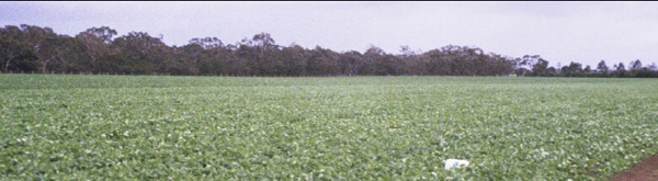 SFS19 Landscape. |
Soil Profile Morphology:
| Surface Soil | 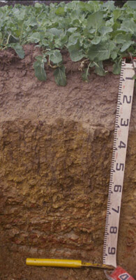 SFS19 Profile. | ||
| Ap | 0-10 cm | Dark brown (10YR3/3); light sandy loam; weakly pedal structure tending to platy at bottom of Ap; weak consistence dry; pH 6.3; clear change to: | |
| A2c | 10-30 cm | Yellowish brown (10YR5/4) conspicuously bleached (10YR6/3 dry); gravelly loam; apedal structure; weak consistence dry; very many medium to coarse (5-20 mm in size) irregular cemented ferruginous nodules (remnants of Moorabool Viaduct sand) as well as rounded quartz alluvial gravel; pH 5.1; sharp and smooth change to: | |
| Subsoil | |||
| B21t | 30-60/70 cm | Brown (10YR5/3) with reddish yellow (7.5YR6/8) mottles; medium clay; strong coarse prismatic, parting to strong medium to coarse blocky and strong fine to medium polyhedral and lenticular structure; strong consistence dry; slickensides evident with thick cutans; pH 6.7; clear change to: | |
| B/C | 60/70-80 cm | Dark red (10R3/6) and red (10R5/8) with coarse reddish yellow (7.5YR6/8) and light grey (2.5Y7/1) mottling; weathered ferruginised Moorabool Viaduct Formation sediments with clay accumulation; rigid ferruginised masses of sandier material than B21 above but with reticulate structure defined by thick bands of illuviated clay; pH 7.6. | |
| C | 80+ cm | Weathered ferruginised Moorabool Viaduct Formation sediments. | |
Key Profile Features:
- Strong texture contrast between surface (A) horizon and subsoil (B21) horizon.
- Conspicuously bleached subsurface (A2) horizon with ferruginous nodules.
Soil Profile Characteristics:
pH | Salinity Rating | |||
Surface (A1 horizon) | Slightly Acid | Low | Non-Sodic | None |
Subsoil (B21 horizon) | Slightly Acid | Very Low | Marginally Sodic | None |
Deeper subsoil (at 60-80 cm) | Slightly Alkaline | Very Low | Sodic | None |
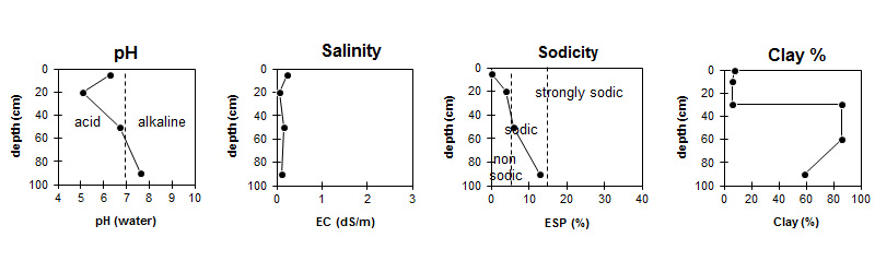
| The salinity rating is low in the surface becoming very low in the subsoil. | The surface is non sodic. The upper subsoil is marginally sodic becoming sodic with depth. | The clay content in the surface is low and sharply increases at the surface / subsoil interface. |
Horizon | Horizon Depth (cm) | pH (water) | pH (CaCl2) | EC dS/m | NaCl % | Exchangeable Cations | |||
Ca | Mg | K | Na | ||||||
meq/100g | |||||||||
AP | 0-10 | 6.3 | 6.1 | 0.22 | 0.01 | 3.3 | 0.7 | 0.5 | <0.1 |
A2 | 10-30 | 5.1 | 4.5 | 0.05 | 0.88 | 0.25 | 0.24 | <0.05 | |
B21+ | 30-60/70 | 6.7 | 6.2 | 0.15 | 5.4 | 7.9 | 1.4 | 0.79 | |
C/B | 60/70-80 | 7.6 | 6.8 | 0.12 | 2.8 | 5.7 | 0.45 | 1.3 | |
Horizon | Horizon Depth (cm) | Exchangeable Aluminium mg/kg | Exchangeable Acidity meq/100g | Oxidisable Organic Carbon % | Total Nitrogen % | Field Capacity pF2.5 | Wilting Point pF4.2 | Coarse Sand (0.2-2.0 mm) | Fine Sand (0.02-0.2 mm) | Silt (0.002-0.02 mm) | Clay (<0.002 mm) |
AP | 0-10 | <10 | 6.9 | 2.6 | 0.29 | 10.4 | 6.4 | 60.4 | 23.8 | 3.0 | 7.5 |
A2 | 10-30 | 18 | 3.7 | 7.0 | 2.6 | 58.7 | 28.5 | 4.0 | 6.0 | ||
B21+ | 30-60/70 | <10 | 8.8 | 50.4 | 30.3 | 6.4 | 2.6 | 2.5 | 86.0 | ||
C/B | 60/70-80 | 30.2 | 19.9 | 23.4 | 10.2 | 6.0 | 58.5 |
Management Considerations:
- The three profiles shown here represent well the variation over short distances (within farm or paddock) for soils developed on the Moorabool Viaduct formation sediments.
- The texture contrast and the sodic subsoil restricts drainage and the soils readily become waterlogged in winter.
- The sandy topsoils are very susceptible to soil structure decline; the weak aggregation is readily destroyed by cultivation and the soils are prone to compaction. Bare soil is vulnerable to structural breakdown by rain (slaking and sealing) and to erosion by water. In dry conditions these soils are known to be vulnerable to wind erosion.
- Plough pans are common in these soils. Disruption of pans by tillage is short lived unless controlled traffic is deployed in cropping situations. Raised beds have been used with some degree of success in these soils but the unstable topsoils do not lend themselves well to bed survival.
- Two additional sites were excavated in the vicinity.
Soil Described By: Richard MacEwan & Mark Imhof (September 2000).
© State of Victoria (Agriculture Victoria) 1996 - .

This work, Victorian Resources Online, is licensed under a Creative Commons Attribution 4.0 licence. You are free to re-use the work under that licence, on the condition that you credit the State of Victoria (Agriculture Victoria) as author, indicate if changes were made and comply with the other licence terms.
The licence does not apply to ‘branding’ or some ‘images or photographs’ that may be owned by third parties. We ask you to seek prior approval to use images using the VRO feedback form. Access to higher quality images can also be provided on request.
This page was last updated on .