
ESAS9
Location: Mingay
Australian Soil Classification: Vertic, Mottled-Mesonatric, Grey SODOSOL
General Landscape Description: Gently undulating plain.
Site Description: Raised bed (2 metre wide) cropping paddock. Gilgai micro relief present.
Geology: Quaternary Basalt.
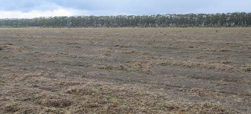 ESAS9 Landscape |
Soil Profile Morphology:
Surface Soil
| A1 | 0-12 cm | Dark greyish brown (10YR4/2); hardsetting and crusting in the surface; fine sandy clay loam; moderate coarse blocky, parting to medium blocky structure; significant amount of buckshot present; pH 5.9: | 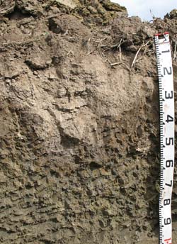 ESAS9 Profile |
| A2 | 12-20/40 cm | Brown (10YR5/3) conspicuously bleached (10YR7/1d); fine sandy clay loam; fine polyhedral structure; pH 5.9; wavy change to: NOTE: depth to subsoil varies due to gilgai. | |
| Subsoil | |||
| B21 | 20/40-50 cm | Dark grey (10YR4/1) with strong brown (7.5YR4/6) mottles; heavy clay; coarse blocky structure; vertic shrink/swell properties; pH 7.1: | |
| B22 | 50-75 cm | Yellowish brown (10YR5/4); heavy clay; lenticular structure; pH 7.8: | |
| B23 | 75-110 cm | Light yellowish brown (2.5Y6/4); heavy clay; coarse lenticular, parting to fine lenticular structure; slickensides evident; pH 8.7. | |
Soil Profile Characteristics:
pH | Salinity Rating | |||
Surface (A1 horizon) | Moderately Acid | Low | Non-Sodic | None |
Subsoil (B21 horizon) | Slightly Alkaline | Low | Strongly Sodic | Strong1 |
Deeper subsoil (at 80-120 cm) | Strongly Alkaline | Medium - High | Strongly Sodic | Strong2 |
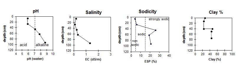
| The surface is moderately acid. The subsoil is slightly alkaline and the deeper subsoil is strongly alkaline. | The salinity rating in the surface is low. The subsoil has a medium to high salinity rating. | The surface is non-sodic. The subsoil is strongly sodic. |
|
Horizon | Horizon Depth (cm) | pH (water) | pH (CaCl2) | EC dS/m | NaCl % | Exchangeable Cations | |||
Ca | Mg | K | Na | ||||||
meq/100g | |||||||||
A1 | 0-12 | 5.9 | 5.4 | 0.17 | 7 | 2.9 | 0.38 | 0.73 | |
A2 | 12-40 | 5.9 | 5.0 | 0.07 | 2.3 | 1.4 | 0.11 | 0.48 | |
B21 | 40-50 | 7.1 | 5.9 | 0.22 | 6 | 8.9 | 0.41 | 5.3 | |
B22 | 50-75 | 7.8 | 6.7 | 0.32 | 0.04 | 6.6 | 10 | 0.32 | 6.7 |
B23 | 75-110 | 8.7 | 8.3 | 1.3 | 0.2 | 7.9 | 14 | 0.37 | 11 |
Horizon | Horizon Depth (cm) | Oxidisable Organic Carbon % | Exchangeable Aluminium mg/kg | Exchangeable Acidity meq/100g | Field Capacity pF2.5 | Wilting Point pF4.2 | Coarse Sand (0.2-2.0 mm) | Fine Sand (0.02-0.2 mm) | Silt (0.002-0.02 mm) | Clay (<0.002 mm) |
A1 | 0-12 | 2.2 | <10 | 7.2 | 24.8 | 11.4 | 17 | 41 | 11 | 26 |
A2 | 12-40 | <10 | 3.9 | 17.5 | 5.9 | 26 | 44 | 6 | 23 | |
B21 | 40-50 | 39.9 | 20.5 | 5 | 33 | 12 | 46 | |||
B22 | 50-75 | 34.5 | 24.9 | 5 | 33 | 16 | 44 | |||
B23 | 75-110 | 46.0 | 24.3 |
Profile Described By: Mark Imhof (March 2008).
© State of Victoria (Agriculture Victoria) 1996 - .

This work, Victorian Resources Online, is licensed under a Creative Commons Attribution 4.0 licence. You are free to re-use the work under that licence, on the condition that you credit the State of Victoria (Agriculture Victoria) as author, indicate if changes were made and comply with the other licence terms.
The licence does not apply to ‘branding’ or some ‘images or photographs’ that may be owned by third parties. We ask you to seek prior approval to use images using the VRO feedback form. Access to higher quality images can also be provided on request.
This page was last updated on .