
Wonga Land System
Wonga Land System (PDF - 165 KB)
Wonga Land System (329 KB)
To view the information PDF requires the use of a PDF reader. This can be installed for free from the Adobe website (external link).
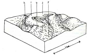
In the northern reaches of the Gellibrand River watershed, an undulating plain is found on the highest parts of the landscape and these areas have been mapped as the Wonga land system. Although existing now more as broad ridge cappings, this land system must have originally covered all the upper reaches of the Tomahawk Creek catchment and across to Loves Creek. Movement along the Loves Creek and Bunker Hill faults have uplifted this block and the resulting geological erosion has left fairly narrow remnants of this undulating plaint along the ridge lines. Some of these remnants fringe the north eastern borders of the Heytesbury Settlement area.
The geology consists of unconsolidated beds of sand and clay belonging to the Dillwyn formation. Large areas of coarse marine sands, however, are uncommon, and the material is fairly similar to the sandy clays of the Mt. Mackenzie land system. This area differs from this land system in that it does not possess a steep, youthful topography but rather an older landscape with relict soils.
Component 1 comprises almost half of the total area of the land system. The mottled yellow red gradational soils encountered here are thought to belong to a previous climatic period which was responsible for the formation of these fine strongly structured mottled clays throughout the study area. Due to the long cycles of leaching they have experienced, they are deficient in many plant nutrients. Although they are well drained and have good water holding capacities, they are not extensively used for agriculture. They support open forests dominated by messmate which are suitable for some scantling timber but are generally only used for posts and poles.
During previous erosional periods there has been some redistribution of sand over the surface of these soils. In many places it does little more than alter the surface texture but where it has accumulated to about 40 cm deep, subsequent weathering and leaching of iron and organic acids to the base of this sand layer has resulted in cementation of the former surface horizon of these red and yellow mottled gradational soils into a hardpan. These areas are represented by component 3. This hardpan thus lies between the sandy surface horizons and the strong fine structured red and yellow mottled clays of the relict soils and has the effect of restricting water movement through the soil. Thus these polygenetic soils are not as well drained as those of component 1, and this is exemplified by a change in the vegetative association to dominance by brown stringybark and an increased occurrence of swamp gum, saw sedge and other moisture loving species. However the drainage impedance is not strong enough to change the structure of the association.
In parts of this landscape, small colluvial fans have formed from redistribution of this material and on these sites deeper deposits of sand, silt and some clay have been formed into somewhat different profiles with hardpans. These areas are represented by component 2. The surface horizons are sandy loams or loamy sands, but below the hardpan layers are found poorly structured sandy clay loams or light sandy clays. They have been included in the same group as the soils of component 3 because many of their physical and chemical properties are similar. The main reason for making this a separate component is that they are generally in poorly drained positions in the landscape and are easily distinguished by the structure of the vegetative association – usually an open woodland or less commonly a closed heath on these soils, in contrast to the open forests elsewhere in the land system. Thus these areas normally have the water table close to the surface in winter and support non commercial stands of timber.
On straight gentle slopes adjacent to the convex rises with mottled yellow red gradational soils and their polygenetic variants are often found slightly more heavier textured soils with strong coarse structured B horizons developed on the same parent material. These soils are thought to belong to the same period of soil formation as the relict soils dominating the Tomahawk Creek land system and are in parts contiguous with them. As such they are prone to similar problems of gullying, slumping and rilling of road batters. Care is needed in their management, particularly on slopes above 10%. Changes in the structure and association of the dominant stratum of the indigenous vegetation are not usually very marked when these soils begin to occur except for the usual increase in abundance of swamp gum. However a strong vegetative indicator is the dramatic increase in narrow leaf wattle in the understorey.
In the eastern parts of this land system closer to the Loves Creek fault, the Paleocene sediments of the Dillwyn formation only shallowly overly the Lower Cretaceous sediments of the Albion formation as exposed in parts of the Otway Ranges further south. As such the shallow dissection has often cut down to this basement of felspathic sandstones. These sandstones are somewhat different from the bulk of the sandstones comprising the Otway Ranges and weather to a soil with more sand size particles than are normally found. The soils developed upon these exposures again have strong coarse structures and are thought to belong to the same climatic period as the soils of the previous component and their equivalents. However being on different and potentially more fertile parent material these soils exhibit different properties from other members in the group. The vegetative association is not much different from that found on component 4 except for the addition of scent bark, but the height of the tallest stratum is generally slightly greater on component 5. Occurrences of these soils in the Heytesbury Settlement area have not yet been observed but they do occur immediately adjacent to the study area in the catchment of Muree Creek.
The climate in this area is quite favourable for plant growth. Restrictions due to cold temperatures occur during the winter months. Water holding capacities of the soils would normally extend the growing season to about late December although the soils with hardpans may be able to make early summer rainfalls available for an extended period by restricting movement of the water through to the clay underlay. The soils in lower slope positions would also probably remain moist for a slightly longer period. The period of active plant growth would normally be for a total of (12-3-3+) = slightly less than 6 months of the year.
As already mentioned, most of the areas in this land system at present remain under natural forest, but naturally those parts which lie within the Heytesbury Settlement area have in places been cleared and developed for agriculture. In view of the high requirement for fertilisers by most soils, agricultural development is not likely to expand in the near future. Conflicts of land use may arise in parts of Tomahawk Creek catchment where domestic water supply catchment areas have been cleared for agriculture. Softwood plantations may be reasonably well suited to these soils and this land use would be more compatible with water supply catchment protection.
 |  |
Area: 24 km2
| Component | 1 | 2 | 3 | 4 | 5 |
| Proportion % | 45 | 7 | 25 | 15 | 8 |
| Climate | |||||
| Rainfall mm | Annual: 850 – 950 Monthly Range: 40 (Jan) – 120 (Aug) | ||||
| Temperature oC | Annual: 12.5 Monthly Range: 8.0 – 18.0 | ||||
Period When Average Monthly Temperature < 10oc June – August Period When Precipitation < Potential Evapotranspiration: Late October – March | |||||
| Geology | |||||
| Age Lithology | Paleocene marine unconsolidated clays, silts and sands | Lower cretaceous felspathic sandstone and siltstone | |||
| Topography | |||||
| Landscape | Undulating plain | ||||
| Elevation M | 120 – 340 | ||||
| Local Relief M | 30 | ||||
| Topography | Parallel and dendritic | ||||
| Drainage Density | 1.2 | ||||
| Landform | Undulating plain | ||||
| Position | Crests, upper slopes | Colluvial fan, swale | Slopes | Lower slopes | Lower slopes |
| Average Slope (Range) | 7% (0% - 12%) | 4% (0% - 7%) | 7% (1% - 16%) | 10% (4% - 14%) | 10% (4% - 14%) |
| Slope Shape | Convex | Concave | Convex | Linear | Linear |
| Native Vegetation | |||||
| Structure Dominant Stratum | Open forest | Open woodland | Open forest | Open forest | Open forest |
| Species | Messmate, Narrow Leaved Peppermint, Brown Stringybark, Occasional Swamp Gum, Manna Gum, Scent Bark | Brown Stringybark Swamp Gum Shining Peppermint | Brown Stringybark Narrow Leaved Peppermint, Swamp Gum, Occasional Scent Bark, Messmate | Messmate, Narrow Leaved Peppermint Swamp Gum, Brown Stringybark | Messmate, Swamp Gum, Narrow Leaved Peppermint Scent Bark |
| Other Common Species | Prickly Tea Tree, Myrtle Wattle, Silver banksia | Prickly Tea Tree, Scented Paperbark, Black Sheoak | Prickly Tea Tree, Narrow Leaved Wattle, Silver Banksia, Red Fruit Saw Sedge, Bracken | Narrow Leaved Wattle, Prickly Tea Tree, Prickly Moses, Myrtle Wattle | Narrow Leaved Wattle, Prickly Moses |
| Soil | |||||
| Parent Material | Unconsolidated clay, silt & sand | Colluvial sand on unconsolidated sand, silt & clay | Colluvial sand on unconsolidated clay, silt & sand | Unconsolidated clay, silt & sand | In-situ weathered rock |
| Group | Mottled yellow, red gradational soils, fine structure | Grey sand soils, compact clay underlay | Grey sand soils, compact clay underlay | Coarse structured yellowish brown gradational soils | Coarse structured yellowish brown grad. Soils |
| Surface Texture | Sandy loam | Sandy loam | Sandy loam | Sandy loam | Sandy clay loam |
| Permeability | Moderate | Slow | Slow | Slow | Slow |
| Av. Depth M | 2 | 2 | 2 | 2 | 1.5 |
| Northcote Class | Gn 3.84 | Gn 4.71 | |||
| Land Use | Uncleared areas: hardwood forestry, domestic water supply protection, wildlife conservation, gravel extraction. Minor cleared areas: beef cattle grazing, dairy farming | ||||
| Hazards Of Soil Deterioration | Low hazard of sheet erosion on the steeper | slopes Moderate hazard of waterlogging | Moderate hazard of gully erosion & rilling of road batters | ||
| Management Practices For Soil Conservation | Maintenance of deep rooted vegetation in drainage lines on lower slopes. Roads & tracks to be designed for good drainage with adequate culverts & table drains. Gravel pits reclaimed with top 40 cm soil when disused. | ||||
© State of Victoria (Agriculture Victoria) 1996 - .

This work, Victorian Resources Online, is licensed under a Creative Commons Attribution 4.0 licence. You are free to re-use the work under that licence, on the condition that you credit the State of Victoria (Agriculture Victoria) as author, indicate if changes were made and comply with the other licence terms.
The licence does not apply to ‘branding’ or some ‘images or photographs’ that may be owned by third parties. We ask you to seek prior approval to use images using the VRO feedback form. Access to higher quality images can also be provided on request.
This page was last updated on .