
Tomahawk Creek Land System
Tomahawk Creek Land System (PDF - 164 KB)
Tomahawk Creek Land System (DOC - 284 KB)
To view the information PDF requires the use of a PDF reader. This can be installed for free from the Adobe website (external link).
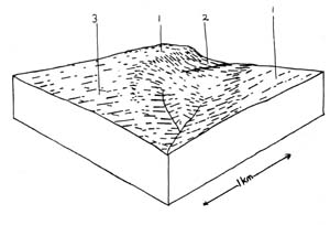
To the east, south and west of the Simpson land system, deep dissection by creeks has created a steeply undulating or rolling landscape, with long slopes coming away from flat plateau remnants to well developed drainage lines. This is the area mapped as the Tomahawk Creek land system. Six components have been recognised in this land system.
Component 1 represents areas of lateritic plateaux which are either too small or too discontinuous to be mapped in with the Simpson land system. This includes both the narrow parallel ridges extending south east and north west from the Simpson land system, and the small isolated remnants found on the south east side of Tomahawk Creek. The soils encountered in this component are almost invariably equivalent to those of component 1 of the Simpson land system, with a similar vegetative association.
Component 2 represents the edges of these plateau remnants where they end abruptly in a steep concave scarp with outcrops of lateritic ironstone weathering to shallow skeletal soils. Eroding and weathering of the lateritic ironstone layer has produced ironstone gravel particles averaging about 15 mm in diameter and these dominate the soil profile. These soils are thus excessively drained and have poor moisture holding capacities as well as low natural fertility. The colluvial ironstone usually extends some distance down the scarp below the thickness of the ironstone layer in the lateritic plateau, and is often present in the solum of middle and lower slope soils. Many gravel extraction pits exist on both freehold and Crown land as the material is popular for road and track construction. The vegetative associations on these soils do not reflect the extremely low fertility and excessive drainage. This is related to the narrow width of these soils such that the roots of eucalypt can penetrate to sandy aquifers just below and thus provide plentiful moisture supplies.
The base of the lateritic profile is underlain in most areas by a nearly horizontal bed of siliceous sand. This bed acts as an excellent aquifer as mentioned above. Recharge is from the Simpson land system through occasional outcrops of the bed or from water moving through the lateritic profile to the sand below. Discharge is through exposures of these beds on the hillsides which thus often coincide with the emergence of springs. These areas tend to become easily pugged and boggy in winter. These are the areas represented by component 3 and the soil and vegetative associations are somewhat similar to those found in the large areas of marine sands on the western periphery of the Otway Ranges. Similarly soils with deep indurated layers are sometimes encountered. These have not been recognised as a separate component here because of their limited occurrence and similar vegetative association in this land system. The emergence of springs through these soils has meant that the main limitation to the growth of eucalypts is fertility of these acid sands, and not moisture deficiency.
Below these fairly narrow beds of siliceous sand lie much less permeable beds of marine clays and silts. Their exposure at middle and lower positions of the slopes is represented by components 4 and 5. Pedological processes on these deposits have led to the development of yellow and grey mottled gradational profiles with large shiny peds in the subsoil. Close examination of these profiles reveals that in most cases the top one metre is occupied by a new soil forming on the remains of a deeper older profile. These heavy clay subsoils are moderately dispersible and evidence of present and past landslips are common. Gully erosion is not common but these soils would be quite susceptible to gully erosion once initiated. Drainage of profiles is somewhat impeded and species such as swamp gum, rushes and saw sedges become common in the vegetative association.
On gentler areas of these soils, layers of colluvial/alluvial sand have been washed over the top of these gradational profiles with heavy clay subsoils. Where these deposits of sand are deep and old enough, a hardpan layer has developed between the sand and the less permeable clay by cementation by iron and organic matter. This process has occurred most commonly on the gentler lower slopes on the south side of Tomahawk Creek, and these soils are represented by component 5. The presence of the hardpan is usually associated with a perched water table and somewhat anaerobic conditions in the topsoil during winter. Thus, more stunted vegetation is usually encountered on component 5 than on component 4. Also included in this component are areas of dissected terraces lying along the valley of Tomahawk Creek. The subsoils of these soils are not as heavily textured and as strongly structured as those described above and are thought to be of more recent origin. However, as they almost invariably have the same deposit of sand with an accompanying hardpan above the subsoil they have very similar properties for plant growth and have been included with the profiles with heavy clay subsoils. Slopes of the dissected terraces are in the range of 1-5% and vegetation is normally a woodland of swamp gum. On the rare areas of dissected terraces that don’t have a sand overlay, open forests of swamp gum and narrow leaved peppermint are found.
Component 6 essentially comprises the present flood plain of Tomahawk Creek and all other drainage lines which are large enough to have developed an alluvial infill. The soils are young and have only weak structures, are moderately permeable, but are in topographic positions such that the water table is close to the surface for a large part of the year.
Restrictions to the period of active plant growth occur for three months during winter and for between 21/2 and 3 months in late summer and early autumn. The duration of this latter restriction depends on the water holding capacity of the soil. The sands of component 3 would be expected to dry out below wilting point well before the heavy clay subsoils of component 4, although the local effect of springs emerging along parts of these components often provides green pick at the base of the lateritic plateaux for the duration of almost the whole of summer. The hardpan layers of component 5 soils have the advantage of holding the moisture from intermittent summer showers close to the surface for use by plants.
Conflicts of land use in this land system appear likely to increase in the future. Dairy farming practices are often incompatible with the use of an area as a domestic water supply catchment and much extension work will be needed to establish satisfactory management practices to minimise contamination of water supplies.
Additional problems could arise from changes in the hydrological balance of this land system. Other landscapes similar to this one in other parts of Australia, where dissection has been deep into an ancient lateritic land surface, are often associated with high quantities of cyclic salt. Clearing of the native vegetation decreases the amount of water lost through transpiration and the groundwater table rises, bringing with it soluble salts. Examples of where this process has happened are in the Dundas Tablelands of Victoria and the Darling Ranges of Western Australia. Due to the high rainfall in this area, soil salting problems are unlikely to become significant, but the expected rise in salinity of runoff water has serious consequences for the future suitability of the area as a domestic water supply catchment.
 |  |
Area: 84 km2
| Component | 1 | 2 | 3 | 4 | 5 | 6 |
| Proportion % | 15 | 6 | 10 | 50 | 9 | 10 |
| Climate | ||||||
| Rainfall mm | Annual: 850 – 1050 Monthly Range: 40 (Jan) – 125 (Aug) | |||||
| Temperature oC | Annual: 13o Monthly Range: 8.0o – 18.5o | |||||
Period when average monthly temperature < 10oC June → August Period when precipitation < Potential evapotranspiration: November → March | ||||||
| Geology | ||||||
| Age Lithology | Lateritised sands and clays of Pliocene Age (Moorabool Viaduct Formation) | Unconsolidated sands, silts and clays of miocene age (gellibrand marl) | ||||
| Topography | ||||||
| Landscape | Deeply dissected remnants of the Simpson Plateau | |||||
| Elevation M | 50 – 160 | |||||
| Local Relief M | 70 | |||||
| Topography | Trellis predominantly but with some dendritic | |||||
| Drainage Density | 2.9 | |||||
| Landform | Plateau Remnants | Scarp | Valley bottom | |||
| Position | Upper slope | Upper slope | Mid slope | Lower slope | ||
| Average Slope (Range) | 1% (0% - 3%) | 28% (13% - 40%) | 12% (8% - 18%) | 12% (8% - 20%) | 5% (1% - 8%) | 0% (0% - 2%) |
| Slope Shape | Straight | Concave | Straight | Straight | Straight | Concave |
| Native Vegetation | ||||||
| Structure Dominant Stratum | Open forest | Open forest | Woodland | Open forest | Low woodland | Woodland |
| Species | Messmate, Brown Stringybark | Messmate, Occasional Manna Gum | Narrow Leaved Peppermint Brown Stringybark, Manna Gum | Swamp Gum, Messmate Narrow Leaf Peppermint Brown Stringybark | Narrowed Leaved Peppermint, Swamp Gum | Manna Gum, Swamp Gum |
| Other Common Species | Large Leaved Bush Pea Dusty Miller, Prickly Tea Tree, Silver Banksia, Mountain Correa Myrtle Wattle | Prickly Tea Tree, Dusty Miller, Silver Banksia | Silver Banksia, Blackboys, Prickly Tea Tree | Narrow Leaved Wattle Prickly Tea Tree Prickly Mosses, Silver Banksia, Dusty Miller, Rush | Prickly Tea Tree | Black Sheoak, Scented Paperb-Ark, Smooth Parrot Pea, Prickly Tea Tree |
| Soil | ||||||
| Parent Material | Weathering lateritic remnants | Colluvial lateritic ironstone | Siliceous sands | Sandy clays (in situ) | Colluvial/alluvial sand over sandy clays | Sand and clay alluvium |
| Group | Mottled yellow red gradational soils with ironstone | Stony red gradational soils | Grey sand soils, uniform texture | Yellowish brown gradational soils coarse structure | Grey sand soils, compact clay underlay | Grey gradational soils |
| Surface Texture | Sandy loam | Gravelly sandy loam | Coarse sandy loam | Sandy loam | Sandy loam | Sandy loam |
| Permeability | Moderate | Extremely rapid | Extremely rapid | Slow | Very slow | Very slow |
| Av. Depth M | 1.6 | 1 | > 2 | > 2 | > 2 | > 2 |
| Northcote Class | Gn 3.94 | Uc 2.36 | Gn 3.54 | Gn 2.92 | ||
| Land Use | Cleared areas: mainly dairy farming, some beef cattle grazing, town water supply production uncleared areas: hardwood forestry production gravel extraction fauna protection, town water supply production | |||||
| Hazards Of Soil Deterioration | Low hazard of sheet erosion | Mod. Hazard sheet erosion | Moderate hazard of landslips, rilling & slumping of road batters soil pugging on poorly drained site | Low hazard of gully erosion | ||
| Management Practices For Soil Conservation | Wintering of stock away from poorly drained areas & fencing out of sites where springs occur on hillslopes. Disposal of dairy effluent away from existing unstable drainage lines, sowing of deep rooted perennial grass species on excessively drained sites. Road batters on component 4 soils kept to less than 1 in 3 slopes. Wherever possible – original vegetation kept in drainage lines | |||||
© State of Victoria (Agriculture Victoria) 1996 - .

This work, Victorian Resources Online, is licensed under a Creative Commons Attribution 4.0 licence. You are free to re-use the work under that licence, on the condition that you credit the State of Victoria (Agriculture Victoria) as author, indicate if changes were made and comply with the other licence terms.
The licence does not apply to ‘branding’ or some ‘images or photographs’ that may be owned by third parties. We ask you to seek prior approval to use images using the VRO feedback form. Access to higher quality images can also be provided on request.
This page was last updated on .