
Swan Marsh Land System
Swan Marsh Land System (PDF - 127 KB)
Swan Marsh Land System (DOC - 221 KB)
To view the information PDF requires the use of a PDF reader. This can be installed for free from the Adobe website (external link).
During the Quaternary Period, volcanic activity has been widespread over Western Victoria and lava flows emerging from cones and vents have extensively modified the landscape. Many of the inland lakes and swamps owe their formation to the blocking of drainage systems by lava flows. One such example is the flat poorly drained area to the north of the Simpson surface mapped as the Swan Marsh land system.
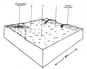
Exactly which basalt flow is responsible for blocking and damming a drainage system is often hard to determine. The drainage lines coming north from the Simpson and Wonga land systems in the vicinity of the Carperdeit road appear to be roughly orientated in the direction of the upper reaches of the Curdie River. The stony rise basalt flow across to Carperdeit appears to have blocked their north westerly course and formed an internal drainage basin. This basin filled and eventually found an outlet to the north west along the edge of the stony rise basalt into Lake Corangamite. The Alluvial sediments derived from the surrounding areas of Tertiary sands, clay and laterite and Quaternary basalts were deposited in the basin.
The soils of the land system vary according to the nature of the alluvium on which they are formed. Thus on areas close to the stony rise basalts, higher proportions of basaltic alluvium result in black cracking clay soils while further south on Hansons plain, weak structured, yellowish grey gradational soils have developed with ironstone present throughout the profile. Naturally, there are numerous examples of soils which are gradations between these two extremities. The soil formed depends on the relative proportions of basaltic alluvium and alluvium from the Tertiary sediments present at each site. Component 1 represents one end of this spectrum.
These black cracking clay soils are typical of the soils developed on alluvium from basalt. They are usually quite fertile with moderate to high levels of organic matter and most other plant nutrients. The surface horizons are heavily textured and hard to work but are often used for cropping. The main problem for management are associated with drainage rather than fertility levels.
The component pattern in further complicated by site drainage. Most areas of the yellowish grey gradational soils receive water from surrounding land systems and are thus water-logged for large parts of the year. As such the vegetation is restricted to a closed scrub of species tolerant of waterlogging with occasional emergents such as swamp gum in a taller stratum. Where the site drainage is improved, open forests of swamp gum dominate and there is usually less organic matter found in the surface horizons. There two drainage conditions are represented by components 3 and 2 respectively.
As mentioned above these soils are formed on alluvium derived from Tertiary sediments and as such would possess similar problems of low nutrient levels. On badly drained sites, surface acidity may also become restrictive to the germination of pasture species.
Restrictions to plant growth due to cold temperatures occur during the winter months. Restrictions due to moisture availability again depend on the water holding capacity of the soil which should be moderately high. Allowing for 120 mm available soil moisture retention on these soils, it is estimated that moisture restrictions to plant growth would normally only occur after the end of December. Moisture stress would then normally be experienced until the season breaks again in early April. Thus the period of active plant growth suffers restrictions for three months in winter and a little over three months in late summer and early autumn.
Except for some of the southern parts of component 3, this land system has been mainly cleared for agriculture. The black cracking clay soils often support good quality pastures and are quite productive. Other areas are not quite as suitable for agriculture but nevertheless could support good pastures under suitable management. However, Hanson’s plain remains as the only large area of the closed scrub vegetation in this part of Victoria which has not yet been cleared. Although it has a slightly different geomorphological history than the closed scrubs of the Simpson and Wonga land systems, it appears to be a suitable area to reserve as a representative community of these once more widespread vegetative association.
 |  |
Area: 3 km2
| Component | 1 | 2 | 3 |
| Proportion % | 40 | 20 | 40 |
| Climate | |||
| Rainfall mm | Annual: 750 – 850 Monthly Range: 35 mm (Jan) – 110 mm (Aug) | ||
| Temperature oC | Annual: 12.5 Monthly Range: 8.0 – 18.5 | ||
Period when average monthly temperature < 10oC June – August Period when precipitation < potential evapotranspiration: Mid October – Early April | |||
| Geology | |||
| Age Lithology | Alluvium of quaternary age derived from surrounding outcrops of basalt, tertiary sands and clays, and laterite. | ||
| Topography | |||
| Landscape | Flat plain | ||
| Elevation M | 150 | ||
| Local Relief M | 1 | ||
| Topography | Centripetal | ||
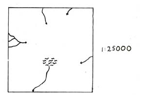
| Drainage Density | 0.4 | ||
| Landform | Flat plain | ||
| Position | Northern parts | Southern parts | Lower areas |
| Average Slope (Range) | 0 (0 – 1) | 0 (0 – 1) | 0 (0 – 1) |
| Slope Shape | Linear | Linear | Linear |
| Native Vegetation | |||
| Structure Dominant Stratum | Open woodland | Open forest | Closed scrub |
| Species | Swamp Gum | Swamp Gum | Black Sheoak, Scented Paperbark, Prickly Tea Tree, Prickly Moses, Red Fruited Saw Sedge Silky Tea Tree |
| Other Common Species | Blackwood, Dogwood | Prickly Tea Tree, Scented Paper-Bark, Prickly Moses, Red Fruited Saw Sedge, Blackwood, Rushes | Swamp Gum Sporadically Occurs As A Higher Stratum |
| Soil | |||
| Parent Material | Alluvium from predominantly basalt | Alluvium from predominantly siliceous sediments | Alluvium from predominantly siliceous sediments |
| Group | Black uniform clays | Yellowish grey gradational soils, coarse weak structure | Yellowish grey gradational soils, coarse weak structure |
| Surface Texture | Medium clay | Sandy clay loam | Clay loam |
| Permeability | Very slow | Slow | Slow |
| Av. Depth M | > 2 | > 2 | > 2 |
| Northcote Class | Ug 5.16 | Gn 4.51 | Gn 4.51 |
| Land Use | Cleared areas: dairy farming, beef cattle grazing, some cropping minor cleared areas: nature conservation | ||
| Hazards Of Soil Deterioration | Moderate hazard of soil pugging and waterlogging | ||
| Management Practices For Soil Conservation | Wintering of stock away from badly drained areas | ||
© State of Victoria (Agriculture Victoria) 1996 - .

This work, Victorian Resources Online, is licensed under a Creative Commons Attribution 4.0 licence. You are free to re-use the work under that licence, on the condition that you credit the State of Victoria (Agriculture Victoria) as author, indicate if changes were made and comply with the other licence terms.
The licence does not apply to ‘branding’ or some ‘images or photographs’ that may be owned by third parties. We ask you to seek prior approval to use images using the VRO feedback form. Access to higher quality images can also be provided on request.
This page was last updated on .