
Mt McKenzie Land System
Mt McKenzie Land System (PDF - 194 KB)
Mt McKenzie Land System (DOC - 391 KB)
To view the information PDF requires the use of a PDF reader. This can be installed for free from the Adobe website (external link).
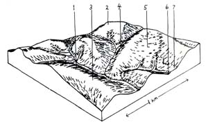
Surrounding the flood plain of the lower reaches of the Gellibrand River are steeply dissected hills with young weak structured soils. Most of the hills have remained uncleared and support open forests of messmate, brown stringybark and other eucalypts. These areas have been mapped as the Mt. Mackenzie land system.
The geology of the land system is unconsolidated deposits of sand, clay and silt of Paleocene age. The sediments have been included in the Dillwyn formation, but they are of quite a different nature to the marine sands found along the western margin of the Otway Ranges. Quite a moderate amount of finer material in these unconsolidated beds leads to moderately textured gradational soil profiles with sandy clay or sandy clay loam textures deep in the profiles with sandy clay or sandy clay loam textures deep in the profile below pedological influences.
The most commonly encountered soils are those of component 1 – yellow gradational soils, weak structure. Closely related are those of component 4 – red gradational soils, weak structure and together these two components comprise 65% of the land system. These soils are quite young and pedologic processes have been restricted to accumulations of organic matter at the surface, moderate leaching to produce slight but definite textural changes down the profile, and minimum weathering of the parent material to smaller clay particles. The textures normally range from loamy sands or sandy loams at the surface to sandy clay loam or light sandy clays in the subsoil. Chaotic floaters of colluvial ironstone ranging to 1 metre in diameter are common. This ironstone is though to have its source in precipitation and cementation by iron from groundwater rather than being remnants of former lateritic periods. In the southern parts of the land system, quarries exist mining extensive deposits of in situ ironstone which is far deeper than that normally former under the pedological processes in laterisation. These soils are generally well drained but fertility levels are not expected to be very high. The steep slopes on which they usually occur, pose serious problems for management, as the poor structures in the surface horizons together with moderate dispersibility means that they are easily sheet eroded.
The difference between the red and yellow forms of these closely related soils is mainly due to minerals present in the parent material. However, the red group does often seem to have a better structure and slightly more texture contrast suggesting that pedological processes have possibly been acting on these soils for longer periods of time.
In the higher position of the landscape are often found areas of coarser sediments and uniform textured sand profiles have developed. These areas are represented by components 3 and 5. They are typical of the soils and vegetation commonly found on the infertile marine sands closer to the Otway Ranges and in this land system are common only in the western parts. No observation of these components in this land system have been made within the Heytesbury Settlement area.
Component 2 represents the flatter hilltops and spurs where somewhat older soils have escaped the geological erosion responsible for the youthful soils and topography characteristic of this land system. These soils are heavier textured with medium clay B horizons and thus have higher moisture holding capacities than those discussed above. They are similar in many structural features to the dominant soils of the Kennedy’s Creek land system and probably belong to the same soil forming cycle. Most of these areas outside the present study area have been cleared and sown to improved pasture for dairy farming of beef cattle grazing.
Similar soils are also found bordering the present flood plain of the Gellibrand River on dissected ancient alluvial terraces as represented by Component 7. Coarse strongly structured B horizons are again found with slickensided ped faces below somewhat variable surface horizons. The dissection of these terraces has no doubt modified the original profile quite considerably and the depth to C horizon material varies from 0.9 metre to 1.6 metre. Most of these dissected terraces have also been cleared for agriculture and often form a useful part of a farming enterprise in providing better drained areas for wintering stock away from the more fertile but often waterlogged or inundated flood plain of the Gellibrand River. The original vegetation on these heavier textured relict soils of component 2 and 7 was an open forest dominated by messmate in association with swamp gum and brown stringybark. This is in contrast to the steep hillside open forests which have brown stringybark as the dominant species.
The drainage lines in this land system are generally filled with a mixture of plant remains and alluvial wash from the surrounding hills. In the steep and narrow upper reaches they usually possess yellow gradational soils, weak structure. Component 6 refers more to the lower reaches where wider and less steep drainage lines are waterlogged for most of the year and the plant remains in the solum are unable to humify. These peaty sands are not as high in organic matter as the peaty sands of the Porcupine Creek land system, though, or as in the drainage lines in the marine sand areas closer to the Otway Ranges. The peaty sands in this land system are also less acid and growth restrictions less severe as messmate and brown stringybark have often colonised these drainage lines as emergents from the open forests on adjacent slopes.
Growth restrictions from cold temperatures in this land system occur in the winter months. Growth restrictions due to moisture deficiency depend again on the moisture holding capacity of the soil. Precipitation normally falls below estimated potential evapotranspiration in mid November and the uniform sands would become dry shortly after this (except for any perched water tables maintained by hardpan layers). The weak structured gradational profiles would probably remain above field capacity until late December, but the best growing season would be found on the heavily textured coarse structured soils of components 2 and 7. Moisture restrictions on these soils would be normally confined to late January, February and March so that the total period of unrestricted plant growth would be 12-3-2½ = 6½ months of the year.
Of the total area of the Heytesbury Settlement Scheme, only very small parts lie within this land system. These have mostly been cleared and have often suffered severe sheet erosion. Of the rest of the land system, the ruggedness of the terrain renders most areas unsuitable for agricultural development. The exceptions to this are the most gentle and fertile areas represented by components 2 and 7. These are mostly cleared and used for dairy farming and some beef cattle grazing. In recent years there has been an increase in clearing of the steep hillsides for pine conversion programs. This is often initiated some serious sheet erosion and siltation problems on these poorly structured soils. As parts of the northern extremities of this land system lie within a domestic water supply catchment, any clearing operations will have a detrimental effect on water quality. Road construction on the weak structured soils of components 1, 3, 4 and 5 also presents some problems. The poor structure of the material means that small rills can quickly develop into large gullies and undermine fill batters if adequate provision is not made for disposing of runoff water. Ironstone quarries in the south do not seem to present serious problems, but some access tracks constructed straight up long steep slopes are now not trafficable due to severe rilling. Thus in general, care is needed in managing these areas and an adequate vegetation cover should be maintained wherever possible.
 |  |
Area: 7 km2
| Component | 1 | 2 | 3 | 4 | 5 | 6 | 7 |
| Proportion % | 40 | 8 | 9 | 25 | 8 | 7 | 3 |
| Climate | |||||||
| Rainfall mm | Annual: 950 – 1100 Monthly Range: 45 (Jan) – 120 (Aug) | ||||||
| Temperature oC | Annual: 12.5 Monthly Range: 8.0 – 18.0 | ||||||
Period When Average Monthly Temperature < 10oC June → August Period When Precipitation < Potential Evapotranspiration: Mid November → March | |||||||
| Geology | |||||||
| Age Lithology | Unconsolidated marine sands, clays and silts of paleocene age | ||||||
| Topography | |||||||
| Landscape | Deeply dissected hills | ||||||
| Elevation M | 15 – 180 | ||||||
| Local Relief M | 100 | ||||||
| Topography | Dendritic with some radial | ||||||
| Drainage Density | 3.3 | ||||||
| Landform | Hills | Swales | Terraces | ||||
| Position | Slopes, crest | Crests, spurs | Crests, slope | Slopes, crest | Lower slopes | ||
| Average Slope (Range) | 33% (4% - 63%) | 14% (4% - 19%) | 32% (22% - 45%) | 37% (31% - 49%) | 14% (2% - 21%) | 4% (0% - 7%) | 5% (1% - 9%) |
| Slope Shape | Convex | Convex | Convex | Convex | Concave | Concave | Convex |
| Native Vegetation | |||||||
| Structure Dominant Stratum | Open forest | Open forest | Low woodland | Open forest | Low woodland | Woodland | Open forest |
| Species | Messmate, Brow-N Stringybark, Shining Peppermint, Narrow Leaved Peppermint | Messmate, Brown Stringybark, Manna Gum, Swamp Gum | Brown Stringybark, Shining Peppermint | Brown Stringybark, Messmate | Shining Peppermint, Brown Stringybark | Messmate, Brown Stringybark | Messmate, Swamp Gum, Brown Stringybark |
| Other Common Species | Occas, Manna Gum, Bracken Prickly Tea Tree Christmas Bush, Sweet Bursaria, | Prickly Tea Tree, Silver Banksia, Austral Grass Tree | Mountain Correa, Prickly Tea Tree, Bracken, Christmas Bush | Black Sheoak, Austral Grasstree | Scented Paperbark, Prickly Tea Tree, Saw Sedge | ||
| Soil | |||||||
| Parent Material | Unconsolidated clay, silt & sand | Unconsolidated clay silt & sand | Unconsolidated sand | Unconsolidated clay silt & sand | Colluvial sand unconsolidated sand, | Plant Remains, Alluvial Sand & Clay | Alluvial Clay, Silt & Sand |
| Group | Yelow grad. Soils, weak structure | Yellowish brown coarse structured grad. Soil | Grey sand soils, uniform texture | Red grad. Soils, weak structure | Grey sand soil with hardpan, uniform texture | Peaty sands | Yellowish brown grad. Soil, coarse structured |
| Surface Texture | Sandy loam | Sandy loam | Loamy sand | Sandy loam | Loamy sand | Sandy loam | |
| Permeability | Rapid | Slow | Rapid | Rapid | Very slow | Rapid | Slow |
| Av. Depth M | > 2 | > 2 | > 2 | > 2 | > 2 | > 2 | |
| Northcote Class | Uc 2.31 | ||||||
| Land Use | Uncleared areas: hardwood & softwood forestry production, town water supply protection, nature conservation, quarrying of ironstone. Minor cleared areas: | ||||||
| Hazards Of Soil Deterioration | Severe hazard of sheet erosion & rilling on steepest slopes when cleared | Mod. haz. of water logging & soil pugging. Minor sheet erosion & / or sedimentation | |||||
| Management Practices For Soil Conservation | Maintenance of complete vegetative cover of soil at all times of year. Wintering of stock away from poorly drained areas. Fence construction away from sensitive areas such as drainage lines or along line of steepest slope. Tracks & roads constructed with adequate table drains & with slopes less than 1 in 10. | ||||||
© State of Victoria (Agriculture Victoria) 1996 - .

This work, Victorian Resources Online, is licensed under a Creative Commons Attribution 4.0 licence. You are free to re-use the work under that licence, on the condition that you credit the State of Victoria (Agriculture Victoria) as author, indicate if changes were made and comply with the other licence terms.
The licence does not apply to ‘branding’ or some ‘images or photographs’ that may be owned by third parties. We ask you to seek prior approval to use images using the VRO feedback form. Access to higher quality images can also be provided on request.
This page was last updated on .