
Kennedy's Creek Land System
Kennedy's Creek Land System (PDF - 176 KB)
Kennedy's Creek Land System (DOC - 314 KB)
To view the information PDF requires the use of a PDF reader. This can be installed for free from the Adobe website (external link).
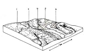
Below the level of the Simpson surface and to the south of the Tomahawk Creek land system lies a moderately extensive area where evidence of any former lateritic plateau is almost completely absent. The landscape is an undulating plain with rounded crests and long straight slopes. Most of the area has been cleared for agriculture and dairy farming is the main land use. This area has been mapped as the Kennedy’s Creek land system.
The geology is somewhat confused and further study is needed to decipher the exact age and formation to which these sediments belong. The area has been mapped as part of the Gellibrand marl but both the soils and the parent material are acidic. These marls are more confined to the Waarre land system where they appear to overly the acidic clays. The age of the acidic clays has been listed as Miocene in the table but they could possibly be older. Soils are in general gradational, in addition to being acidic, and have medium to heavy clay subsoils. The uncleared parts of the landscape support good quality hardwood forests.
Four separate components have been recognised in the landscape and they each appear to coincide with different periods of soil formation. Component 1 includes soils with similar physical characteristics to the most commonly encountered soil of the Simpson surface (similar structure, mottling, colour etc.). Unlike those on the Simpson surface, they overly unconsolidated marine clays, and not lateritic ironstone*. They are encountered on rounded convex slopes on the upper parts of the landscape and appear to coincide with one of the earlier periods of soil formation. These clays are generally prone to slaking, but have low dispersibilities and so are fairly stable to rilling and gullying. Sheet erosion can occur however in the light textured topsoils. The long periods of weathering and leaching that these soils have undergone during formation have resulted in the removal of many plant nutrients so that low level of nitrogen, phosphorus, potassium, copper and molybdenum are common.
Due to rejuvenation and dissection of this landscape most of these older soils have been removed and on long straight slopes coming away from these convex upper surfaces yellowish brown gradational soils with heavy clay subsoils have developed. In most cases, the top metre of the profile is occupied by a moderately structured younger soil reforming out of a deeper strongly structured heavy clay. These heavy clays are undoubtedly the B horizons of another group of relict soils which have formed in a climatic cycle subsequent to the one responsible for red and yellow mottled fine structured gradational soils. They are distinguished by large slickensided ped faces and shiny surfaces in a grey heavy clay with yellow mottles.
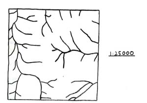
Permeability of these soils appears to be much slower than those of component 1 as is revealed by the marked increase in the number of minor drainage lines present in this part of the landscape. In addition, the heavy clay subsoils are quite dispersable and gully and tunnel erosion are quite common in these minor drainage lines. Minor landslipping is also observed on the steepest slopes, particularly in the southern parts of the land system around Valley-view road and Wiridjil road. Good quality open forests of messmate, manna gum and scent bark are found on the uncleared areas of this component. Scent bark seems to prefer these heavy textured and slowly permeable soils and is a strong indicator species this land system. The additional occurrences of swamp gum and narrow leaved peppermint help to distinguish this component from others in the land system but these species are not always present.
On lower concave slopes, particularly in the southern parts of the land system, are found more stable and finer structured soils which appear to coincide with yet another period of soil formation subsequent to that responsible period of soil formation subsequent to that responsible for the heavy clay subsoils above. Being limited in occurrence these soils have not been examined in detail. They do not appear to pose the same management problems as the soils of component 2 although gullies may be initiated if water is artificially concentrated down minor drainage lines.
Component 4 includes all the slightly broader drainage lines with an alluvial infill. In addition, minor areas of older, alluvial terraces along the margins of Kennedy’s Creek have been included in this component. There is a certain amount of variation between soils of the different terraces surrounding the major and minor creeks. These differences are again probably due to slightly different ages and periods of soil formation. However the differences are not considered to be important enough to warrant separation at this level of mapping. The soils are generally gradational and exhibit a coarse weak structure in the subsoil. Some examples of shallow gullies can be seen in the southern parts of the land system. Due to the position in the landscape, waterlogging is often a problem in winter and spring and stock should be kept away from these areas during the wet parts of the year.
Growing seasons are difficult to estimate because of the lack of full climatic data in this vicinity. However extrapolating from the three nearest stations and making allowances for slight maritime influences, growth restrictions due to cold should be limited to June, July and August when the average temperature falls below 10oC. As the soils have moderately deep clay subsoils, water holding capacities should be good. Allowing 100 mm of water for an average water holding capacity, the carryover moisture from spring into summer means that growth should be restricted by available moisture from late January till the end of March. The period of unrestricted plant growth is for the remaining 6½ months of the year.
Generally this land system has a moderate to high capability for agriculture. As previously mentioned dairy farming is the major form of land use and beef cattle grazing is common. Some areas have been reserved for hardwood forestry production.
Problems arise from the susceptibility of component 2 soils to gully erosion and the fairly low nutrient status of most of the soils. However the moderately long period of non restricted plant growth helps to maintain a high level of production from this area.
*The exception to this generalisation is on the slopes north of the junction of Kennedy’s Creek and the Gellibrand River. Here a layer of lateritic ironstone some 10 cm thick is commonly encountered about 1.8 metres below the surface of soils about halfway down these convex slopes. The topographic situation here is quite unlike remnants of the Simpson surface found in the Tomahawk Creek land system and it is proposed that these this remnants of lateritic ironstone may coincide with sloping
extremities of the former Simpson surface.
 |  |
Area: 82 km2
| Component | 1 | 2 | 3 | 4 |
| Proportion % | 20 | 65 | 6 | 9 |
| Climate | ||||
| Rainfall mm | Annual: 950 – 1050 Monthly Range: 40 (Jan) – 130 (Aug) | |||
| Temperature oC | Annual: 12.5 Monthly Range: 8.5 – 18.0 | |||
Period when average monthly temperature < 10oc June – August Period when precipitation < potential evapotranspiration: November - March | ||||
| Geology | ||||
| Age Lithology | Unconsolidated marine clays, silts and sands of Miocene age. | Recent alluvium | ||
| Topography | ||||
| Landscape | Undulating plain | |||
| Elevation M | 15 – 150 | |||
| Local Relief M | 70 | |||
| Topography | Predominantly dendritic with some trellis | |||
| Drainage Density | 4.0 | |||
| Landform | Undulating plain | Alluvial terraces | ||
| Position | Upper slopes, crests | Middle slopes | Lower slopes | |
| Average Slope (Range) | 9% (4-15%) | 10% (4-20%) | 10% (7-35%) | 5% (1-9%) |
| Slope Shape | Convex | Straight | Concave | (Variable-mostly straight) |
| Native Vegetation | ||||
| Structure Dominant Stratum | Open forest | Open forest | Open forest | Woodland |
| Species | Messmate, Manna Gum, Occas, Swamp Gum | Scent Bark, Manna Gum, Messmate, Narrow Leave-D Peppermint, Swamp Gum | Messmate, Narrow Leaved Peppermint, Occas, Manna Gum | Swamp Gum, Messmate, Manna Gum |
| Other Common Species | Narrow Leaved Wattle, Prickly Tea Tree, Prickly Moses | Narrow Leaved Wattle, Dusty Miller, Prickly Moses, Wiry Bauera, Myrtle Wattle | Narrow Leaved Wattle, Dusty Miller, Wiry Bauera, Prickly Moses, Silver Banksia | Scented Paperbark, Prickly Tea Tree, Red Fruit Saw Sedge, Wiry Bauera |
| Soil | ||||
| Parent Material | Unconsolidated clays and silts | Unconsolidated clays and silts | Unconsolidated clays and silts | Alluvial clay, Silt and sand |
| Group | Mottled yellow red gradational soils, fine structure | Yellowish brown gradational soils, coarse structure | Greyish brown gradational soils | Yellowish grey gradational soils, coarse weak structure |
| Surface Texture | Fine sandy loam | Fine sandy loam | Fine sandy loam | Sandy loam |
| Permeability | Moderate | Slow | Moderate | Slow |
| Av. Depth M | > 2 | > 2 | > 2 | > 2 |
| Northcote Class | Gn 3.94 | Gn 4.71 | ||
| Land Use | Cleared areas: dairy farming, beef cattle grazing, domestic water supply protection Uncleared areas: domestic water supply protection, hardwood forestry production, nature conservation | |||
| Hazards Of Soil Deterioration | Low hazard of sheet erosion | Severe hazard of gully and tunnel erosion. Mod hazard of landslips | Low hazard of gully erosion | Mod. haz. of waterlogg-ing & soil pugging. Low haz. of gully rosion. |
| Management Practices For Soil Conservation | Planting or maintenance of original vegetation in drainage lines disposal of dairy effluent away from existing unstable drainage lines wintering of stock away from poorly drained sites. Road batters kept to less than 1 in 3 slopes | |||
© State of Victoria (Agriculture Victoria) 1996 - .

This work, Victorian Resources Online, is licensed under a Creative Commons Attribution 4.0 licence. You are free to re-use the work under that licence, on the condition that you credit the State of Victoria (Agriculture Victoria) as author, indicate if changes were made and comply with the other licence terms.
The licence does not apply to ‘branding’ or some ‘images or photographs’ that may be owned by third parties. We ask you to seek prior approval to use images using the VRO feedback form. Access to higher quality images can also be provided on request.
This page was last updated on .