Your gateway to a wide range of natural resources information and associated maps

Victorian Resources Online

Geological & Geomorphological Sites of Significance - Otway

Back to: Sites of Geological & Geomorphological Significance in the Shire of Otway Region

Sites of Geological and Geomorphological Significance in the Shire of Otway Region (PDF 1027KB)
The high resolution PDF file provided on this page can be viewed using the free Adobe PDF reader and this software can be installed from the Adobe website (external link). This PDF is provided with a high level of detail and with the intent that it should be printed at a high resolution.

This is a clickable map. Click site on the map for more information. Alternatively click on the linked site below to access information.
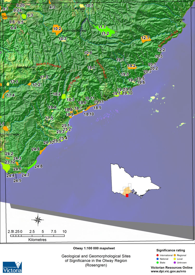
Map:  Sites of Geological & Geomorphological Significance -  Otway Artillery Rocks Point Sturt - Shore Platform and Terrace View Point - Emerged Platform Lake Elizabeth and Landslide Cape Patton Point Franklin Parker River to Point Lewis Older Volcanics Basalt Plug - Gellibrand Bentonite Quarry - Gellibrand Boggaley Creek Boulder Beach Aire River - Landslip Lake Barham River East Branch Ridge - Landslip Control Kennett River - Emerged Platform Sugarload Hill and Terrace Carisbrook Falls Cape Otway Elliott River - Accordant Stream Mouths Barham River Lagoon Marengo Terrace - Swell Point to Storm Point The Blowhole Gellibrand River - High level prior channel Loves Creek - Brown Coal and Limestone Gellibrand "Shale Pit" Gellibrand River - Valley Form and Landslips at Upper Gellibrand Barwon River West Branch Swamp Barwon River East Branch Landslip Cumberland River Gorge Hopetoun Falls - Aire Valley Skenes Creek - Black Coal Rusty Road Falls Wild Dog Gorge Apollo Bay Escarpment and Terrace Wye River Valley Point Hawdon Cape Patton - Tertiary Sediments Von Mueller Creek - Shore Platform Wye River - Rampart on Shore Platform E S Hill - Precipitation Ridge Parker Estuary Crayfish Bay Stony Creek Apollo Bay Terrace Barwon River (West Branch) Landslips - Forrest Upper Gellibrand Falls Little Aire Creek Landslip - Paradise Smythe Creek Valley Head Landslip - Wild Dog Creek Barham Valley Kennett River - Outcrop Barham River - Isolated Hill Skenes Creek Shore Platform - Dinosaur Footprints Kennett River - Lower Valley Swamp - Kawarren East Point Flinders Tertiary Gravels - Gellibrand Aire River Entrenched Meander Skenes Creek Terrace Skenes Creek Monocline Cape Otway East

    Geological & Geomorphological Sites of Significance - Otway

International SignificanceRegional SignificanceLocal Significance
12.2 Artillery Rocks4.3 Valley Swamp - Kawarren East4.1 Gellibrand River Tributary
20.2 Point Sturt - Shore Platform and Terrace9.1 Gellibrand River - High level prior channel4.2 River Capture - Kawarren
20.3 View Point - Emerged Platform9.2 A/B Loves Creek - Brown Coal and Limestone10.1 Barwon River (West Branch) Landslips - Forrest
9.5 Gellibrand "Shale Pit"10.3 Upper Gellibrand Falls
National Significance9.6 Tertiary Gravels - Gellibrand10.4 Kennett River - Lower
11.1 Lake Elizabeth and Landslide10.2 Gellibrand River - Valley form and Landslip at Upper Gellibrand17.1 Little Aire Creek
19.10 Cape Patton10.4 Barwon River West Branch Swamp17.5 Landslip - Paradise
24.7 Point Franklin 11.2 Barwon River East Branch Landslip18.1 Smythe Creek Valley Head
24.8 Parker River to Point Lewis12.1 Cumberland River Gorge18.3 Landslip - Wild Dog Creek
17.2 Hopetoun Falls - Aire Valley18.4 Barham Valley
State Significance17.4 Aire River entrenched meander19.3 Kennett River - Outcrop
9.3 Older Volcanics Basalt Plug - Gellibrand18.5 Skenes Creek Monocline19.4 Kennett River - Lower
9.4 Bentonite Quarry - Gellibrand18.6 Skenes Creek - Black Coal25.3 Barham River - Isolated Hill
12.3 Boggaley Creek Boulder Beach18.7 Rusty Road Falls
17.3 Aire River - Landslip Lake18.8 Wild Dog Gorge
18.2 Barham River East Branch Ridge - Landslip control18.9 Apollo Bay Escarpment and TerraceUnknown Significance
19.5 Kennett River - Emerged Platform18.11 Skenes Creek Terrace18.10 Skenes Creek Shore Platform - Dinosaur Footprints
19.7 Sugarloaf Hill and Terrace19.2 Wye River Valley24.5 Cape Otway East
19.8 Carisbrook Falls19.6 Point Hawdon
23.12 Point Flinders19.9 Cape Patton - Tertiary Sediments
24.4 Cape Otway19.11 Von Mueller Creek - Shore Platform
24.10 Elliott River - Accordant Stream Mouths20.1 Wye River - Rampart on Shore Platform
24.11 Shelly Beach24.2 E. S. Hill - Precipitation Ridge
25.2 Barham River Lagoon24.3 Parker Estuary
25.4 Merengo Terrace - Swell Point to Storm Point24.6 Crayfish Bay
25.5 The Blowhole24.9 Stony Creek
25.1 Apollo Bay Terrace
Page top