
Kangaroo Hills (Kingston)
|
372100S 1440030E; 7723-3-4 (Eganstown) 345618. 11 km W of Daylesford. | 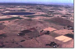 Kangaroo Hills (Hepburn Lagoon in background) | |
Kangaroo Hills Road, Mays Road. | ||
Creswick. | ||
Private land. Cropping and grazing, some trees, no outcrop. | ||
| Type 5: | Scoria with cone crater. | |
Kangaroo Hills are adjacent circular scoria domes. Both have shallow depressions on the western slope. These may be erosional or slump features and scoria may have accumulated from one vent with directional fire-fountaining. If the depressions are remnant crater forms then two eruptions points are inferred. | ||
678 m; 120 m. | ||
Regional: | These are prominent landforms and provide an interesting problem in interpretation of the style of eruption. The site lies just north of Hepburn Lagoon maar. The details of eruption sequence of Kangaroo Hills and the relationship to the maar eruption is not known and provides a significant research issue. | |
CLass 2: | The current agricultural land use is compatible with maintaining the geological and geomorphological values of the site. The site would be threatened by smaller farm development or subdivision. | |
| References: | Coulson, A. (1954). The volcanic rocks of the Dayles ford district. Proceedings of the Royal Society of Victoria 65, pp. 113-124. | |

© State of Victoria (Agriculture Victoria) 1996 - .

This work, Victorian Resources Online, is licensed under a Creative Commons Attribution 4.0 licence. You are free to re-use the work under that licence, on the condition that you credit the State of Victoria (Agriculture Victoria) as author, indicate if changes were made and comply with the other licence terms.
The licence does not apply to ‘branding’ or some ‘images or photographs’ that may be owned by third parties. We ask you to seek prior approval to use images using the VRO feedback form. Access to higher quality images can also be provided on request.
This page was last updated on .