
Land Use
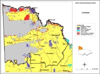 Mallee Landuse | This map is based on general statewide information obtained by satellite image interpretation (1991) and from other statewide datasets. It was initially prepared for State of Environment reporting in 1991and provides a general indication only, of land use and land tenure across the Mallee region. Data used to generate this map was derived from the land use layer (LANDUSE250) of the DPI/DSE Corporate Geospatial Data Library. | 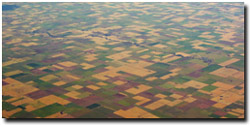 Cropping in the southern Mallee (November 2003) |
© State of Victoria (Agriculture Victoria) 1996 - .

This work, Victorian Resources Online, is licensed under a Creative Commons Attribution 4.0 licence. You are free to re-use the work under that licence, on the condition that you credit the State of Victoria (Agriculture Victoria) as author, indicate if changes were made and comply with the other licence terms.
The licence does not apply to ‘branding’ or some ‘images or photographs’ that may be owned by third parties. We ask you to seek prior approval to use images using the VRO feedback form. Access to higher quality images can also be provided on request.
This page was last updated on .