
Geomorphology
Physiography and Geomorphology | Victoria's Geomorphological Framework | Mapping | Victorian Geomorphology Reference Group (VGRG) | History | Examples of Applications | Related Links | References
Introduction
The land and soils that support our agricultural industries are managed in many different ways that reflect the diversity of Victoria’s landscape. Landscapes are shaped by geomorphological and pedological processes (Conacher 2002). Geomorphology is the study of landforms, their origin and evolution, the investigation of relationships between landform development and processes that shape and configure these landforms such as tectonic movement, volcanism, erosion and deposition cycles (Hills 1975; Rosengren 1984: Ahnert 1998). Importantly, geomorphology provides a ‘fundamental template on which landscape processes and human interactions with those processes take place’ (Conacher 2002).
Understanding the land resource, its condition and inherent capability provides a basis for sustainable land use. Collection of information to support land management and land use planning programs has largely been based on Land Systems approaches. Land Systems are derived by integrating environmental features including geology, landform, climate, soils and native vegetation using an ecological approach (Christian and Stewart 1946).
In Victoria, the approach was used by Rowan and Downes (1963) and Gibbons and Downes (1964). Since the first surveys there have been many land system and soil/terrain related surveys that were combined to form a land systems map of the state. The first complete Victoria Land Systems map coverage was produced by Rowan (1990) and an unpublished second draft by Rowan, Russell and Ransome (1994). The most recent version of the statewide land systems has been edited by Rees in Rowan, Russell, Ransome and Rees (2000). Digital Elevation Models (DEM), Geographic Information System (GIS), Airborne Gamma-Ray Spectrometry (AGRS), Light Detection and Ranging (LiDAR) and satellite imagery have produced spatial datasets not previously available thereby presenting opportunities to re-assess landscapes, refine boundaries and define critical land attributes not previously possible.
Mapping
Geomorphological maps have been developed throughout the world, particularly with the increasing availability and use of Geographical Information Systems (GIS). Some are based on generalised mapping, while others emphasise specific areas of geomorphology for particular purposes such as land use planning or hazard mapping (Ahnert 1998). Maps of geomorphic land units can be rich in attributes including altitude, slope, aspect, soils, climate and vegetation. This information then allows further analysis of landscape processes such as water movement and erosion.
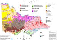
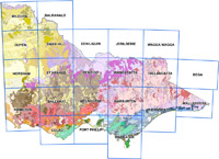
| Over the last decade in Victoria, geomorphology has been used to create a hierarchical classification of landforms and landscapes, known as the Victorian Geomorphology Framework (VGF). The VGF is a spatial framework consisting of a hierarchical system of land unit descriptions. The framework hierarchy is a spatial system to assist planning, monitoring and reporting for natural resource management in Victoria and Australia. The VGF describes and defines details of Victoria’s landscapes and provides a hierarchy to align past and future soil and land information. The tiered system incorporates information from geomorphology, pedology and ecology fields, enabling users to gain an understanding of both soil and vegetation distribution. The VGF comprises a three-tier system, incorporating eight ‘level one’ divisions (Map 1), 34 ‘level two’ divisions (Map 2) and 95 ‘level three’ divisions (Map 3). A significant addition in the VGF has been the inclusion of a coastal geomorphology division. The development of a third tier for the VGF has allowed complexity within larger units to be separated into units that had not been defined in previous geomorphology systems. Within the hierarchy, there exists a hiatus between the coarsest division of the VGF (tier one) and the finest scale of land management units (tier 6). This hiatus is largely due to the degree of complexity that exists between and within land units (divisions) across equivalent tiers of the VGF. The revision of Victoria’s land resource mapping and descriptions has been undertaken to update and refine spatial land entities, including land systems, for Victoria. The VGF used newly available technology, such as airborne gamma ray spectrometry (radiometrics) and improved Digital Elevation Models (DEMs) such as the Shuttle Radar Topographic Mission (SRTM). | 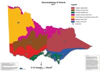 Geomorphology of Victoria - Tier 1 | |
 Geomorphology of Victoria - Tier 2 | ||
 Geomorphology of Victoria - Tier 3 |
A spatial dataset of Geomorphology of Victoria is freely available through the DataVic website.
Geomorphology of Victoria - Regional Overviews
These regional overview maps (including links to the geomorphological map unit descriptions) are provided for the catchment management authority (CMA) regions of Victoria - Mallee, Wimmera, Glenelg-Hopkins, Corangamite, Port Phillip & Westernport, West Gippsland , East Gippsland ,North East, Goulburn Broken and North Central.
Related Links
- Statewide Land Systems This section provides information on Land System mapping in Victoria.
- Regional Land Systems This section provides maps and reports on the regional Land System mapping undertaken in Victoria.
- Land Use Describes the major land use categories in Victoria and provides numerous links to historical and current land use information, spatial frameworks and related links.
- Primary Production Landscapes A regional approach to analysis of different farming systems, practices and productivity in different parts of the state and where land use in placed in the state providing regionally relevant scenarios and advice.
- The Australian and New Zealand Geomorphology Group (ANZGG)
- International Association of Geomorphologists (IAG)
References
Ahnert F (1998) Introduction to Geomorphology. Arnold, London, UK.
Christian CS, Stewart GA (1953) General Report on Survey of the Katherine-Darwin Region, 1946. Land Research Series No. 1, CSIRO, Australia.
Conacher A (2002) A Role for Geomorphology in Integrated Catchment Management. Australian Geographical Studies 40(2):179–195.
Gibbons FR, Downes RG (1964) A Study of the Land in South-western Victoria. Technical Communication No. 3. Soil Conservation Authority, Victoria.
Hills ES (1975) Physiography of Victoria (First edition). Whitcombe & Tombs, Melbourne.
Rees DB (2000) Land systems of Victoria. Edition 3. Technical Report No. 56, Centre for Land Protection Research, Bendigo.
Rosengren N (1984) Sites of geological and geomorphological significance in the Shire of Otway. Department of Conservation, Forests and Lands.
Rowan JN (1990) Land systems of Victoria. Land Conservation Council, Melbourne.
Rowan JN, Downes RG (1963) A Study of the Land in North-western Victoria. Technical Communication No. 2. Soil Conservation Authority, Victoria.
Rowan JN, Russell L, Ransome S (1994) Land systems of Victoria, edition 2 (unpublished).
© State of Victoria (Agriculture Victoria) 1996 - .

This work, Victorian Resources Online, is licensed under a Creative Commons Attribution 4.0 licence. You are free to re-use the work under that licence, on the condition that you credit the State of Victoria (Agriculture Victoria) as author, indicate if changes were made and comply with the other licence terms.
The licence does not apply to ‘branding’ or some ‘images or photographs’ that may be owned by third parties. We ask you to seek prior approval to use images using the VRO feedback form. Access to higher quality images can also be provided on request.
This page was last updated on .