
6.1 Volcanic plains
6. Western Plains (WP)
6.1.1 Eruption points; maars, scoria cones and lava shields, including associated ash and scoria deposits (Lake Purrumbete, Mt Elephant, Mt Cottrell)
6.1.2 Stony rises (Mt. Eccles, Pomborneit, Mt Rouse)
6.1.3 Plains with poorly developed drainage and shallow regolith (Wingeel)
6.1.4 Plains with well developed drainage and deep regolith (Cressy)
6.1.5 Terraces, floodplains and lakes, swamps and lunettes and their deposits (Lough Culvert, Lower Woady Yallock, Chain of Ponds, Condah Swamp, Lake Murdeduke & lunette
| The volcanic plains were built up by sporadic volcanic eruptions over a period of about 5 million years, and are known geologically as the Newer Volcanics, the deposits which form the Newer Volcanic Province of Victoria, which includes parts of the Western Uplands, the Western Plains, and the area across the border around Mt Gambier. Much of the plains were formed from lobes of lava which flowed from the eruption points, overlapping to form a veneer of basalt lava flows. The flow varies in thickness according to both the underlying topography and the present-day surface. The flows are interleaved in places with pyroclastic deposits (scoria and tuff) and discontinuous buried palaeosoils of variable thickness. Drainage across the volcanic plains is generally poorly developed. The uplift of the Otway Ranges and the disruption of drainage by the volcanic eruptions resulted in the formation of a shallow basin in the central region, where most of lakes, including Lake Corangamite, are found. Fluctuating lake levels during the Pleistocene resulted in lunette formation, especially prominent in the Beeac-Eurack district. | 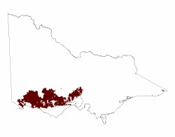 |
While grasslands are common on much of the plains lava, and on many of the cones, dense trees commonly mark the young stony rise flows, and large scattered Red Gums are found on the deeply-weathered older flows, for example south of Hamilton.
Related information on VRO
- A Study of the Land in South-western Victoria (F R Gibbons and R G Downes 1964)
- A Land Resource Assessment of the Corangamite Region (Robinson et al 2003)
- Soils and Landforms of south-western Victoria Part 1, Inventory of soils and their associated landscapes (J Maher and J Martin 1987)
© State of Victoria (Agriculture Victoria) 1996 - .

This work, Victorian Resources Online, is licensed under a Creative Commons Attribution 4.0 licence. You are free to re-use the work under that licence, on the condition that you credit the State of Victoria (Agriculture Victoria) as author, indicate if changes were made and comply with the other licence terms.
The licence does not apply to ‘branding’ or some ‘images or photographs’ that may be owned by third parties. We ask you to seek prior approval to use images using the VRO feedback form. Access to higher quality images can also be provided on request.
This page was last updated on .