
4. Northern Riverine Plain (RP)
Victoria's Geomorphological Framework (VGF)
4.1 - Modern floodplains
4.2 - Older alluvial plains
4.3 - Alluvial fans and aprons (Burnt Creek, Seven Creek, Broken River, Katamatite, Raywood & aprons around Korong, Dookie Hills)
4.4 - Hills and low hills (Terrick Terrick Range, Mt Major, Mt Wycheproof)
| On the Riverine Plain of northern Victoria, many parallel streams head northerly across a strikingly flat plain to meet the current course of the River Murray. Initially the pattern would have been difficult to visualise, but with long, detailed mapping of soils, geology and landforms a clearer picture emerged, to be confirmed by later mapping using aerial photographs and satellite imagery. Studies of groundwater and salinity, and recent dating by luminescence, have also helped provided a better understanding of landscape evolution. The Riverine Plain of New South Wales and Victoria is a very extensive and complex alluvial plain associated with the River Murray and its tributaries which developed following the retreat of the Neogene (Pliocene) sea from the Murray Basin. Two of these tributaries, the Avoca and Wimmera Rivers, now fail to reach the Murray River and terminate in lakes. Although the plain is predominantly alluvial in origin, episodes of wind blown deposition did occur during arid times. The most continuous and extensive part occurs form the plains east of the Loddon River, where it extends northwards from the Eastern uplands to the River Murray. In the west of the state, around Horsham and Donald, it extends north of the Western uplands to where it meets the Northwest Dunefields and Plains. The climate of the Northern Riverine Plains is semi-arid in the northwest and subhumid in the east and southeast. Most of the area originally carried eucalypt woodlands with occurrences of casuarinas, but there were substantial areas of treeless plain. Changing climate, vegetation, runoff and evaporation during the Quaternary have produced palaeochannels of different ages. | 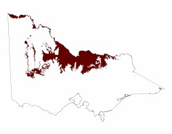 |
The Riverine Plain consists essentially of two geological formations. The most extensive and older is the Shepparton Formation of late Neogene (Pleistocene) (4.2), and the Recent Coonambidgal Formation (4.1). The older terraces and fans (4.3) adjoining the Eastern Uplands (1) and Western Uplands (2) are also regarded as belonging to the Shepparton Formation. Low residual hills occur within the Riverine Plain (4.4) but these are mostly comprised of Palaeozoic rocks. Apart from the alluvial fans and aprons (4.3), the Shepparton formation may be subdivided into three units – plains with small, meandering, leveed stream channels (4.2.1), which died out as distributaries away from their uplands source, plains without channels (4.2.2) which are often treeless, and plains with lakes and lunettes (4.2.3). Many of the present lakes in the Murray Basin are ephemeral or relict features, evidence of much more efficient hydrological regimes during the Neogene (Middle and Late Pleistocene). Most are now either permanently dry or episodically filled by floodwaters.
Much of the Riverine Plain west of the Campaspe River is made up of plains without leveed stream channels (4.2.2), whereas to the east the plains have meandering leveed channels (4.2.1) which would have flowed to the north and north-west. Within the Wimmera CMA region are alluvial fans and aprons (4.3) and lakes and basins with lunettes (4.2.3) and plains without leveed channels (4.2.2). Higher terraces, alluvial fans and aprons of uncertain age occur along the edge of the uplands, for example along the Mackenzie River and north and east of the Grampians.
Further reading
Butler B. E. 1950. A theory of prior streams as a causal factor of soil occurrence in the Riverine Plain in south-eastern Australia. Australian Journal of Agricultural Research 1, 231-252. 2238.
Butler B. E. 1956. Parna – aeolian clay. Australian Journal of Science. 18, 145-151.
Bowler J. M. and Harford, L. B. 1966. Quaternary tectonics and the evolution of the Riverine Plain near Echuca, Victoria. Journal of the Geological Society of Australia. 13, 339-354.
Churchward H. M. 1963. Soil studies at Swan Hill. 2. Dune moulding and parna formation. Australian Journal of Soil Research. 1, 103-116.
Lawrence C. R. 1966. Cainozoic stratigraphy and structure of the Mallee region, Victoria. Proceeding of the Royal Society of Victoria 79, 517-554.
Thorne A. G. and Macumber P. G. 1972. Discovery of late Pleistocene man at Kow Swamp, Australia. Nature 238, 316-319.
Pels, S. Late Quaternary Chronology of the Riverine Plain of Southeastern Australia. Journal of the Geological Society, Australia. 13, 27-40.
Skene J. K. M. Skene and Poutsma T. J. 1962. Soils and Land Use in Part of the Goulburn Valley, Victoria. Department of Agriculture Technical Bulletin No 14.
Detailed Soil Surveys of the Goulburn-Broken and the North Central Catchment Regions provide additional information on soils, landform, climate and vegetation. These are available via Victorian Resources On-line at:
© State of Victoria (Agriculture Victoria) 1996 - .

This work, Victorian Resources Online, is licensed under a Creative Commons Attribution 4.0 licence. You are free to re-use the work under that licence, on the condition that you credit the State of Victoria (Agriculture Victoria) as author, indicate if changes were made and comply with the other licence terms.
The licence does not apply to ‘branding’ or some ‘images or photographs’ that may be owned by third parties. We ask you to seek prior approval to use images using the VRO feedback form. Access to higher quality images can also be provided on request.
This page was last updated on .