
2.2 Strike ridges and valleys - Grampians Range
- 2.2.1 Cuesta landscapes (Serra Range, Victoria Range)
- 2.2.2 Sandstone hills (Black Range)
- 2.2.3 Valleys, alluvial terraces and floodplains (Victoria Valley)
2. Western Uplands (WU)
2.2.1 Cuesta landscapes (Serra Range, Victoria Range)
2.2.2 Sandstone hills (Black Range)
2.2.3 Valleys, alluvial terraces and floodplains (Victoria Valley)
| The strike ridges and valleys consist of a series of parallel ranges extending in a north-south orientation for nearly 90 kilometres (Sibley 1967). The ranges are characterised by striking cuesta-and-vale morphology with dipping sandstone beds to the west and scarp faces pointing to the east. The sandstones outcrop as three mountain ranges, Mount William Range in the east, Victoria Range to the west and various broken ranges in-between Mt Zero and Mt Sturgeon known as the Serra Range. These ranges are thought to have been derived through multiple repetitions (stacking) of three stratigraphic units along bedding parallel faults within siltstone (Cayley & Taylor 1998). The escarpments, steep slopes and sharp crests are in contrast to the rest of the Western Uplands which generally have rounded topography. Major valleys and subsequent streams have developed along fault lines or less resistant siltstones and shales (Spencer-Jones 1965; Cayley & Taylor 1997; Hills 1975) with ranges interrupted by granitic intrusions in the Victoria Valley (negative relief granite) and at Mt William. A major structural monocline at Wartook Reservoir has resulted in dissection and displacement with the MacKenzie River occupying a synclinal valley towards Mt Difficult and Mt Victory (Hills 1975). Terraces and floodplains occupy valleys and are dominated by sourced material from sandstones and weathered granite. | 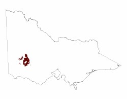 |
Related information on VRO
- A Study of the Land in the Grampians Area (G T Sibley 1967)
- Land Inventory of the Wimmera Systems and Rocklands Water Supply Catchments - A Reconnaissance Survey (L A White, P J Kelynack, F Gigliotti, P D Cook 1985)
- A Study of the Land in South-western Victoria (F R Gibbons and R G Downes 1964)
© State of Victoria (Agriculture Victoria) 1996 - .

This work, Victorian Resources Online, is licensed under a Creative Commons Attribution 4.0 licence. You are free to re-use the work under that licence, on the condition that you credit the State of Victoria (Agriculture Victoria) as author, indicate if changes were made and comply with the other licence terms.
The licence does not apply to ‘branding’ or some ‘images or photographs’ that may be owned by third parties. We ask you to seek prior approval to use images using the VRO feedback form. Access to higher quality images can also be provided on request.
This page was last updated on .