
2.1 Dissected Uplands
- 2.1.1 Ridges, escarpments, mountains on non-granitic Palaeozoic rocks (Ararat, Colbinabbin, Pyrenees, Tarrangower, Big Hill, Mt Macedon)
- 2.1.2 Hills, valley slopes and plains on non-granitic Palaeozoic rocks (Daylesford, Maryborough, Bendigo)
- 2.1.3 Ridges, escarpments, mountains on granitic Palaeozoic rocks (Mt. Cole, Langi Ghiran, Mt. Beckworth, Mt. Alexander)
- 2.1.4 Hills, valley slopes and plains on plutonic Palaeozoic rocks (Pittong, Harcourt, Amphitheathre, Victoria Valley)
- 2.1.5 Plateaux and rises of residual Cainozoic landscapes (Dereel, Meredith, White Hills, Trentham)
- 2.1.6 Eruption points and volcanic plains (Creswick - Ballarat plains, Mt. Franklin, Mt. Blackwood, Metcalfe)
- 2.1.7 Terraces and floodplains (Upper Loddon, Upper Woady Yallock Creek, Pomonal - Moyston area, Crowlands, Avoca, Newstead)
2. Western Uplands (WU)
2.1.1 Ridges, escarpments, mountains on non-granitic Palaeozoic rocks (Ararat, Colbinabbin, Pyrenees, Tarrangower, Big Hill, Mt Macedon)
2.1.2 Hills, valley slopes and plains on non-granitic Palaeozoic rocks (Daylesford, Maryborough, Bendigo)
2.1.3 Ridges, escarpments, mountains on granitic Palaeozoic rocks (Mt Cole, Langi Ghiran, Mt Beckworth, Mt Alexander)
2.1.4 Hills, valley slopes and plains on plutonic Palaeozoic rocks (Pittong, Harcourt, Amphitheatre, Victoria Valley)
2.1.5 Plateaux and rises of residual Cainozoic landscapes (Dereel, Meredith, White Hills, Trentham)
2.1.6 Eruption points and volcanic plains (Creswick - Ballarat plains, Mt Franklin, Mt Blackwood, Metcalfe)
2.1.7 Terraces and floodplains (Upper Loddon, Upper Woady Yallock Creek, Pomonal - Moyston area, Crowlands, Avoca, Newstead)
| The dissected uplands are characterised by a variety of interwoven landforms preserved by substantial uplift during the Palaeogene (Carey & Hughes 2002) and late Neogene (Taylor et al. 1996). Undulating hills and broad valleys characterise the Palaeozoic sedimentary rocks and granitic plutons. Remnants of an early Cainozoic palaeoplain occur as caps of Palaeogene gravels sporadically distributed at various elevations, such as those around Meredith. A remnant of the sands deposited during the Pliocene marine regression fringes the southern Palaeozoic rocks as a dissected tableland around Illabarook and Rokewood. During the Plio-Pleistocene, volcanic eruptions filled the broad valleys to form elongate basalt plains and a variety of other volcanic landforms. The prominent volcanic cones of Mount Buninyong (745 m), Mount Warrenheip (741 m) and Tipperary Hill (743 m) are now the highest elevations in the Corangamite CMA region. | 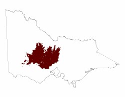 |
Related information on VRO
- Land Inventory of the Loddon River Catchment - a reconnaissance survey (Noel Schoknecht 1988)
- A Study of the Land in the Campaspe River Catchment (M. S. Lorimer and N. R. Schoknecht 1987)
- A Study of the Land in the Catchment of the Avoca River (M. S. Lorimer and J. N. Rowan 1982)
- Preliminary Land Capability Study in the Shire of Talbot/Clunes (R T Costello 1981)
- A Study of the Land in the Grampians Area (G T Sibley 1967)
- Land Inventory of the Wimmera Systems and Rocklands Water Supply Catchments - A Reconnaissance Survey (L.A. White, P. J. Kelynack, F. Gigliotti, P. D. Cook 1985)
© State of Victoria (Agriculture Victoria) 1996 - .

This work, Victorian Resources Online, is licensed under a Creative Commons Attribution 4.0 licence. You are free to re-use the work under that licence, on the condition that you credit the State of Victoria (Agriculture Victoria) as author, indicate if changes were made and comply with the other licence terms.
The licence does not apply to ‘branding’ or some ‘images or photographs’ that may be owned by third parties. We ask you to seek prior approval to use images using the VRO feedback form. Access to higher quality images can also be provided on request.
This page was last updated on .