
Weathering of Ferruginised Regolith and 'Tiger Mottles'
Typical Soil Profiles | Weathering of Ferruginised Regolith | Redox Weathering of Ferruginised Regolith | Clay Illuviation in Weathered Regolith | Summary
The information that follows was developed by Richard MacEwan (former Department of Primary Industries) as a presentation to explain the weathering features in ferricrete i.e. iron cemented parent material, in south-west Victoria and their relationship to ironstone gravels and mottling in the soil profiles.
There are often questions asked about the origins of buckshot and gravel in texture contrast (duplex) soils with the debate usually focussed on pedogenic processes of reduction, mobilisation, oxidation and precipitation. The study here concentrates on a particular banded morphological feature in the regolith which we have referred to as “tiger mottles”. This term was used by a Japanese scientist who visited the Australian Soil Science Society (ASSSI) Conference in Melbourne in 1996. On a field trip in the Dundas Tablelands, a profile in weathered rhyolite was displayed in which there was clear banding of iron-rich and iron-depleted or kaolinised material. These features were of interest given their potential importance in the lateral flow of water in the landscape below the root zone. The Japanese guest on observing these, remarked “ah tiger mottles”. This was considered to be an apt description and DEPI pedologists have been using the term casually ever since. So this presentation serves a documentation purpose in describing the features, explaining their pedology and offering the term for general usage.
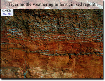 |
This image shows the lower part of a soil profile and the underlying regolith in the Hanson Plain Sand, south east of Colac in south west Victoria, Australia. The iron rich material is extremely hard to auger and in the normal course of a soil survey this material would not be seen, but thanks to the installation of a gas pipeline in Victoria (Port Campbell to Lara) in 1999 several examples of the weathering regolith and overlying soil profile were revealed. The distinctive banding or “tiger mottling” was evident in a number of areas. The material shown in this image occurs between 1.2 and 3.0 metres below the land surface. The lower portion of the image shows a largely ferruginised sandstone that is undergoing weathering. The broad mottling pattern of yellow and red indicates hydrolysis of the hematite in the ferricrete and conversion to goethite. The horizontal linear features of alternating red and grey are the “tiger mottles”. |
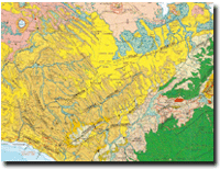
This image is taken from the 1:250 000 geology map. The green unit in the south-eastern corner is the Otway range, an uplifted Cretaceous unit which bounds the SE edge of a large graben which was progressively filled, first with terrestrial sediments and subsequently marine sediments (clays and marls) and ultimately coastal outwash and alluvial material (sands and gravels). The yellow unit is the remnant plain of coastal material (Hanson Plain Sand and Moorabool Viaduct) and is now a plateau. The ferruginised regolith with tiger mottles is found in the “Hanson Plain Sand”. The brown unit is the underlying marine marl (Gellibrand Marl) which has been exposed by dissection of the plateau. To the north, the pink land unit represents the southern extremity of the basalt plain. |
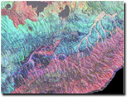 | This is a ternary radiometric image of the same area. The pink areas show high potassium, which is present in the basalt and in the Cretaceous sediments of the Otway range. The dark areas at the top of the image are lakes: Lake Colac on the right and the southern tip of Lake Corangamite to the left. The Hanson Plain Sand unit is low in potassium (K) and is the paler area of blue. The arcuate forms traversing roughly NW-SE are interpreted as the result of retreating shorelines. |
© State of Victoria (Agriculture Victoria) 1996 - .

This work, Victorian Resources Online, is licensed under a Creative Commons Attribution 4.0 licence. You are free to re-use the work under that licence, on the condition that you credit the State of Victoria (Agriculture Victoria) as author, indicate if changes were made and comply with the other licence terms.
The licence does not apply to ‘branding’ or some ‘images or photographs’ that may be owned by third parties. We ask you to seek prior approval to use images using the VRO feedback form. Access to higher quality images can also be provided on request.
This page was last updated on .