
Salinity Management in the Corangamite CMA
- Salinity Monitoring
- Salinity Processes
- Groundwater Flow Systems
- Salinity Discharge Mapping
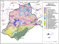
- Salinity and Simplified Geology
Salinity Monitoring | Salinity Processes | Groundwater Flow Systems | Salinity Indicator Plants | Salinity Discharge Mapping | Salinity Provinces in the Corangamite CMA
This section has been developed in association with Peter Dahlhaus, University of Ballarat.
Salinity has been a feature of the Corangamite region for at least 20 000 years. The development of the large clay lunettes at Lake Corangamite and Lake Murdeduke testify to the salinity of these lakes. Clay lunettes form during arid periods when the lake beds are dry salt pans, where salt accumulates by evaporation of groundwater discharge. Historical evidence for primary salinity is documented in accounts of the early exploration and ‘salt’ is often used as a descriptive adjective for lakes and creeks in the region.
At present 20 538 hectares of salinity have been mapped in the Corangamite region by the former DPI's Centre for Land Protection Research (CLPR). About half of the mapped salinity is primary, although this distinction has little meaning anyway in situations where the rate of naturally occurring salinity is modified by human changes to the environment, especially when the changes have occurred over centuries. The mapping does not include all large lakes, such as Lake Corangamite, or all estuarine areas, such as the Aire River estuary. In fact, the salinity mapping is regarded as incomplete and it is believed that many hectares of salt affected land remain unmapped. |
Related Links
| Murray-Darling Basin Salinity Management Strategy. Information about the 15 year Basin Salinity Management Strategy (2001-2015) on the Murray Darling Basin Commission website (external link). Includes downloadable documents. |
| Murray-Darling Basin Salinity Audit (external link). Provides detailed predictions for all major river valleys in the Murray-Darling Basin for the next 20, 50 and 100 years. |
| Effectiveness of Current Farming Systems in the Control of Dryland Salinity. (external link) A downloadable CSIRO publication on the Murray Darling Basin Commission website. To view the information PDF requires the use of a PDF reader. This can be installed for free from the Adobe website (external link). |
| The Department of Agriculture, Fisheries and Forestry Australia website provides a range of documents related to Salinity Risk Management (external link) in Australia (including: the salinity problem; integrated salt risk characterisation and salinity risk management).
|
| Information about salinity on the Australian Academy of Sciences website (external link). |
| The House of Representatives Standing Committee on Science and Innovation tabled its report on June 21st 2004 - entitled Science overcoming salinity: Coordinating and extending the science to address the nation's salinity problem (external link). A copy of the entire report is available for download on the Parliament of Australia House of Representatives website. |
| The Australian Government's Department of Agriculture, Fisheries and Forestry website provides a range of salinity information (external link) (including major programs and initiatives, research and development, salinity advice and salinity monitoring and assessment) as well as information about the National Dryland Salinity Program (external link) (including salinity mapping methods, Groundwater Flow Systems, desalinisation technologies and the Australian Dryland Salinity Assessment 2000). |
© State of Victoria (Agriculture Victoria) 1996 - .

This work, Victorian Resources Online, is licensed under a Creative Commons Attribution 4.0 licence. You are free to re-use the work under that licence, on the condition that you credit the State of Victoria (Agriculture Victoria) as author, indicate if changes were made and comply with the other licence terms.
The licence does not apply to ‘branding’ or some ‘images or photographs’ that may be owned by third parties. We ask you to seek prior approval to use images using the VRO feedback form. Access to higher quality images can also be provided on request.
This page was last updated on .